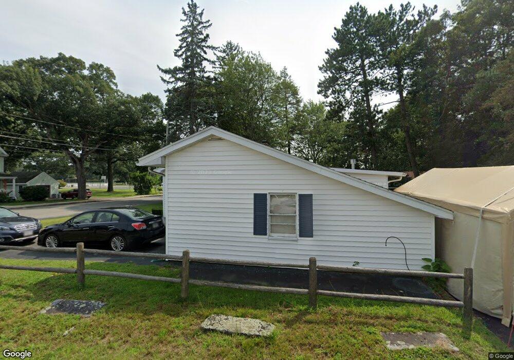
73 Central St Woburn, MA 01801
Walnut Hill NeighborhoodEstimated Value: $679,000 - $727,000
2
Beds
1
Bath
864
Sq Ft
$814/Sq Ft
Est. Value
About This Home
This home is located at 73 Central St, Woburn, MA 01801 and is currently estimated at $702,983, approximately $813 per square foot. 73 Central St is a home located in Middlesex County with nearby schools including Goodyear Elementary School, John F. Kennedy Middle School, and Woburn High School.
Ownership History
Date
Name
Owned For
Owner Type
Purchase Details
Closed on
Nov 16, 2020
Sold by
Duffy Jena H
Bought by
Chamberlain Matthew
Current Estimated Value
Home Financials for this Owner
Home Financials are based on the most recent Mortgage that was taken out on this home.
Original Mortgage
$465,500
Outstanding Balance
$414,229
Interest Rate
2.8%
Mortgage Type
New Conventional
Estimated Equity
$288,754
Create a Home Valuation Report for This Property
The Home Valuation Report is an in-depth analysis detailing your home's value as well as a comparison with similar homes in the area
Home Values in the Area
Average Home Value in this Area
Purchase History
| Date | Buyer | Sale Price | Title Company |
|---|---|---|---|
| Chamberlain Matthew | $490,000 | None Available |
Source: Public Records
Mortgage History
| Date | Status | Borrower | Loan Amount |
|---|---|---|---|
| Open | Chamberlain Matthew | $465,500 |
Source: Public Records
Tax History Compared to Growth
Tax History
| Year | Tax Paid | Tax Assessment Tax Assessment Total Assessment is a certain percentage of the fair market value that is determined by local assessors to be the total taxable value of land and additions on the property. | Land | Improvement |
|---|---|---|---|---|
| 2025 | $4,747 | $555,800 | $334,600 | $221,200 |
| 2024 | $4,351 | $539,800 | $318,600 | $221,200 |
| 2023 | $4,445 | $510,900 | $298,700 | $212,200 |
| 2022 | $4,315 | $462,000 | $260,900 | $201,100 |
| 2021 | $3,949 | $423,300 | $248,900 | $174,400 |
| 2020 | $3,828 | $410,700 | $248,900 | $161,800 |
| 2019 | $3,651 | $384,300 | $237,500 | $146,800 |
| 2018 | $3,523 | $356,200 | $218,600 | $137,600 |
| 2017 | $3,399 | $342,000 | $208,700 | $133,300 |
| 2016 | $3,239 | $322,300 | $195,600 | $126,700 |
| 2015 | $3,110 | $305,800 | $183,400 | $122,400 |
| 2014 | $2,953 | $282,900 | $183,400 | $99,500 |
Source: Public Records
Map
Nearby Homes
- 35 Grape St
- 3 Frank St
- 18 Central St
- 13 Fremont St Unit 13
- 6 Stratton Dr Unit 404
- 6 Stratton Dr Unit 410
- 18 Carmen Terrace
- 19 Mason Way Unit 75
- 2 Mason Way Unit 6524
- 6 Mason Way Unit 6324
- 10 Mason Way Unit 61
- 14 Grant Rd
- 2 Archer Dr Unit 1
- 2 Stratton Dr Unit 1109
- 3 Laurel St
- 51 Vernon St
- 571 Washington St
- 18 Gardner Ave
- 1 Boline Place
- 200 Ledgewood Dr Unit 505