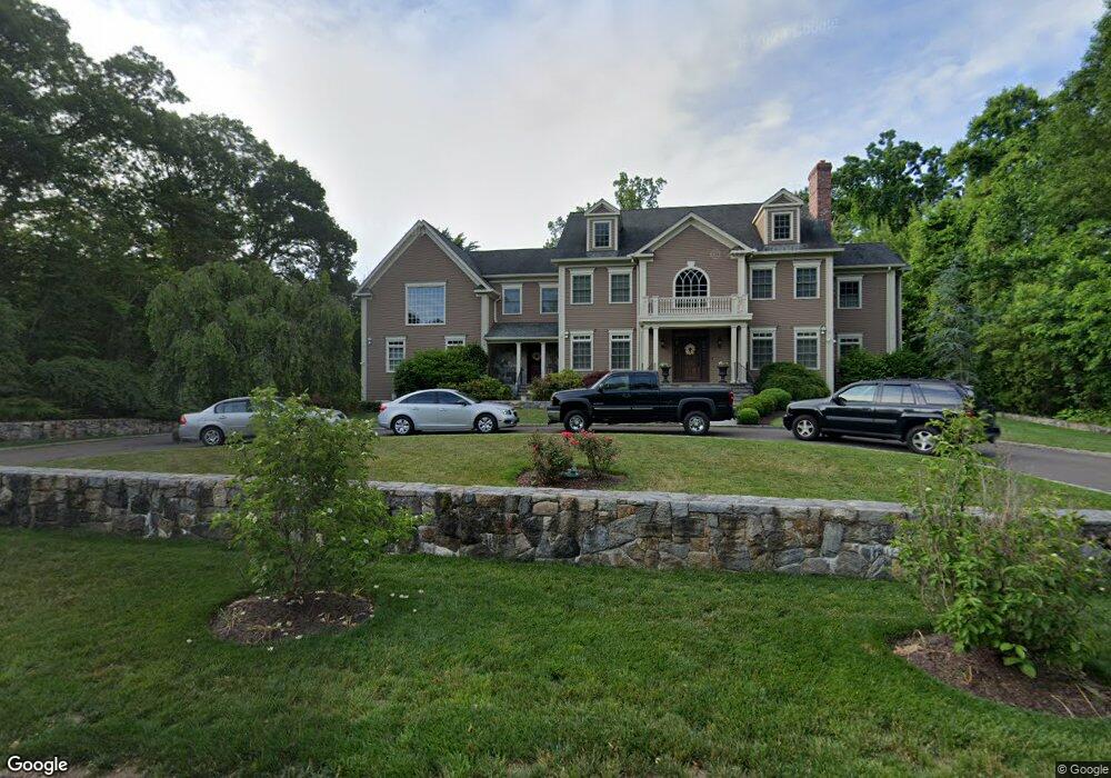
73 Flint Rock Rd Stamford, CT 06903
North Stamford NeighborhoodEstimated Value: $2,253,000 - $2,856,000
4
Beds
6
Baths
5,892
Sq Ft
$413/Sq Ft
Est. Value
About This Home
This home is located at 73 Flint Rock Rd, Stamford, CT 06903 and is currently estimated at $2,435,970, approximately $413 per square foot. 73 Flint Rock Rd is a home located in Fairfield County with nearby schools including Roxbury School, Cloonan School, and Westhill High School.
Ownership History
Date
Name
Owned For
Owner Type
Purchase Details
Closed on
Dec 16, 2011
Sold by
76 Roosevelt Ave Assoc
Bought by
Chiapetta Don and Webb Debra
Current Estimated Value
Purchase Details
Closed on
Feb 20, 1992
Sold by
Gold Edward and Gold Ellen
Bought by
Presutto Don and Presutto Patricia
Purchase Details
Closed on
Apr 15, 1988
Sold by
Maurer Walter
Bought by
Gold Edward
Create a Home Valuation Report for This Property
The Home Valuation Report is an in-depth analysis detailing your home's value as well as a comparison with similar homes in the area
Home Values in the Area
Average Home Value in this Area
Purchase History
| Date | Buyer | Sale Price | Title Company |
|---|---|---|---|
| Chiapetta Don | $250,000 | -- | |
| Presutto Don | $325,000 | -- | |
| Gold Edward | $385,000 | -- |
Source: Public Records
Mortgage History
| Date | Status | Borrower | Loan Amount |
|---|---|---|---|
| Previous Owner | Gold Edward | $370,000 | |
| Previous Owner | Gold Edward | $500,000 | |
| Previous Owner | Gold Edward | $135,000 |
Source: Public Records
Tax History Compared to Growth
Tax History
| Year | Tax Paid | Tax Assessment Tax Assessment Total Assessment is a certain percentage of the fair market value that is determined by local assessors to be the total taxable value of land and additions on the property. | Land | Improvement |
|---|---|---|---|---|
| 2025 | $31,878 | $1,369,920 | $263,320 | $1,106,600 |
| 2024 | $31,179 | $1,369,920 | $263,320 | $1,106,600 |
| 2023 | $33,508 | $1,369,920 | $263,320 | $1,106,600 |
| 2022 | $29,599 | $1,124,170 | $199,480 | $924,690 |
| 2021 | $29,195 | $1,124,170 | $199,480 | $924,690 |
| 2020 | $28,475 | $1,124,170 | $199,480 | $924,690 |
| 2019 | $28,475 | $1,124,170 | $199,480 | $924,690 |
| 2018 | $27,486 | $1,124,170 | $199,480 | $924,690 |
| 2017 | $31,981 | $1,189,320 | $216,830 | $972,490 |
| 2016 | $29,519 | $1,189,320 | $216,830 | $972,490 |
| 2015 | $28,710 | $1,189,320 | $216,830 | $972,490 |
| 2014 | $27,723 | $1,189,320 | $216,830 | $972,490 |
Source: Public Records
Map
Nearby Homes
- 368 Den Rd
- 51 Northwood Ln
- 14 Constance Ln
- 43 Constance Ln
- 24 Old Orchard Ln
- 107 June Rd
- 2 Butternut Place
- 1489 Long Ridge Rd
- 0 June Rd Unit LOT 1 24118127
- 0 June Rd Unit 3 170606008
- 65 Malibu Rd
- 25 Wire Mill Rd
- 151 June Rd
- 160 Wire Mill Rd
- 494 Sawmill Rd
- 226 Cedar Heights Rd
- 11 Dundee Rd
- 21 Timber Mill Rd
- 391 Sawmill Rd
- 30 Partridge Rd
- 89 Flint Rock Rd E
- 65 Flint Rock Rd
- 171 Hardesty Rd
- 103 Flint Rock Rd E
- 51 Flint Rock Rd
- 11 Iron Gate Rd
- 173 Hardesty Rd
- 14 Iron Gate Rd
- 135 Hardesty Rd
- 21 Iron Gate Rd
- 56 Flint Rock Rd
- 41 Flint Rock Rd
- 117 Flint Rock Rd E
- 42 Valley View Dr
- 38 Flint Rock Rd
- 44 Flint Rock Rd
- 27 Iron Gate Rd
- 26 Iron Gate Rd
- 148 Hardesty Rd
- 4 Valley View Dr