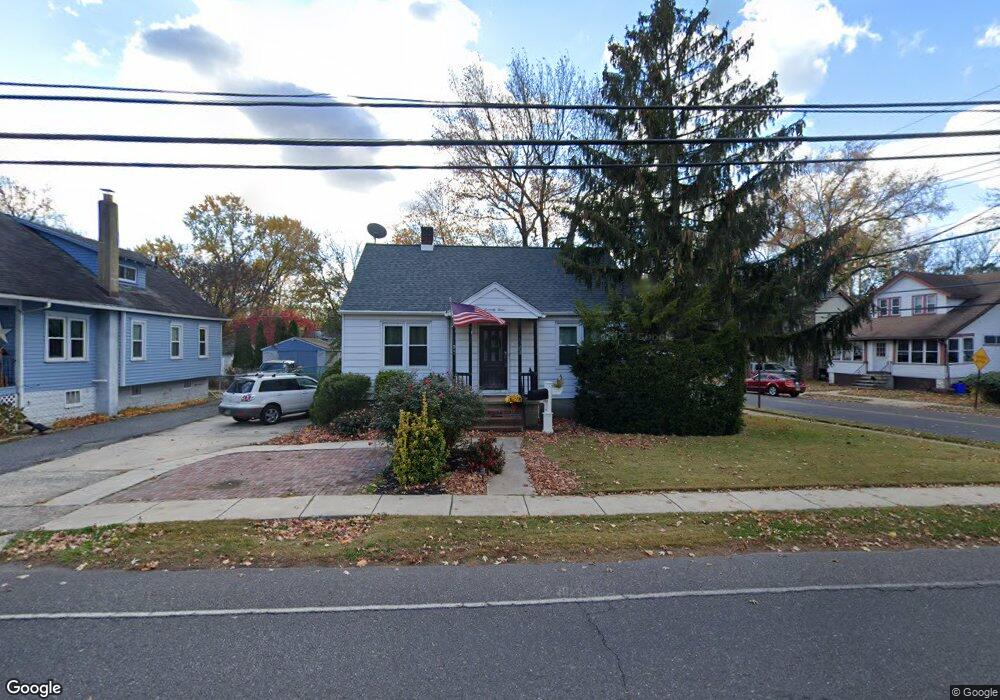
73 Hessian Ave West Deptford, NJ 08096
Estimated Value: $240,841 - $321,000
--
Bed
--
Bath
1,836
Sq Ft
$153/Sq Ft
Est. Value
About This Home
This home is located at 73 Hessian Ave, West Deptford, NJ 08096 and is currently estimated at $281,210, approximately $153 per square foot. 73 Hessian Ave is a home located in Gloucester County with nearby schools including Woodbury Junior/Senior High School and Holy Angels Catholic School.
Ownership History
Date
Name
Owned For
Owner Type
Purchase Details
Closed on
Sep 8, 2021
Sold by
Villari Joseph D and Villari Katherine
Bought by
Villari Joseph D
Current Estimated Value
Home Financials for this Owner
Home Financials are based on the most recent Mortgage that was taken out on this home.
Original Mortgage
$128,800
Interest Rate
2.8%
Mortgage Type
New Conventional
Purchase Details
Closed on
Mar 14, 2005
Sold by
Villari Donna R and Villari Salvatore J
Bought by
Villari Joseph D
Home Financials for this Owner
Home Financials are based on the most recent Mortgage that was taken out on this home.
Original Mortgage
$133,000
Interest Rate
5.78%
Mortgage Type
Purchase Money Mortgage
Create a Home Valuation Report for This Property
The Home Valuation Report is an in-depth analysis detailing your home's value as well as a comparison with similar homes in the area
Home Values in the Area
Average Home Value in this Area
Purchase History
| Date | Buyer | Sale Price | Title Company |
|---|---|---|---|
| Villari Joseph D | -- | Pietras Lisa J | |
| Villari Joseph D | -- | None Listed On Document | |
| Villari Joseph D | $140,000 | -- |
Source: Public Records
Mortgage History
| Date | Status | Borrower | Loan Amount |
|---|---|---|---|
| Previous Owner | Villari Joseph D | $128,800 | |
| Previous Owner | Villari Joseph D | $133,000 |
Source: Public Records
Tax History Compared to Growth
Tax History
| Year | Tax Paid | Tax Assessment Tax Assessment Total Assessment is a certain percentage of the fair market value that is determined by local assessors to be the total taxable value of land and additions on the property. | Land | Improvement |
|---|---|---|---|---|
| 2025 | $6,230 | $129,500 | $34,000 | $95,500 |
| 2024 | $6,009 | $129,500 | $34,000 | $95,500 |
| 2023 | $6,009 | $129,500 | $34,000 | $95,500 |
| 2022 | $5,825 | $129,500 | $34,000 | $95,500 |
| 2021 | $5,825 | $129,500 | $34,000 | $95,500 |
| 2020 | $6,182 | $125,200 | $36,000 | $89,200 |
| 2019 | $5,975 | $125,200 | $36,000 | $89,200 |
| 2018 | $5,842 | $125,200 | $36,000 | $89,200 |
| 2017 | $5,743 | $125,200 | $36,000 | $89,200 |
| 2016 | $5,663 | $125,200 | $36,000 | $89,200 |
| 2015 | $5,570 | $125,200 | $36,000 | $89,200 |
| 2014 | $5,483 | $125,200 | $36,000 | $89,200 |
Source: Public Records
Map
Nearby Homes
- 66 Hessian Ave
- 112 Progress Ave
- 120 Progress Ave
- 1029 Tatum St
- 70 Crescent Ave
- 121 Crescent Ave
- 41 Crescent Ave
- 38 Watkins Ave
- 17 Magnolia St
- 131 Watkins Ave
- 17 Peach St
- 17 Watkins Ave
- 58 Fisher Ave
- 33 Dubois Ave
- 1174 Harker Ave
- 193 Dubois Ave
- 541 Elberne Ave
- 210 Lawnton Ave
- 86 Peach St
- 654 Frances Ave