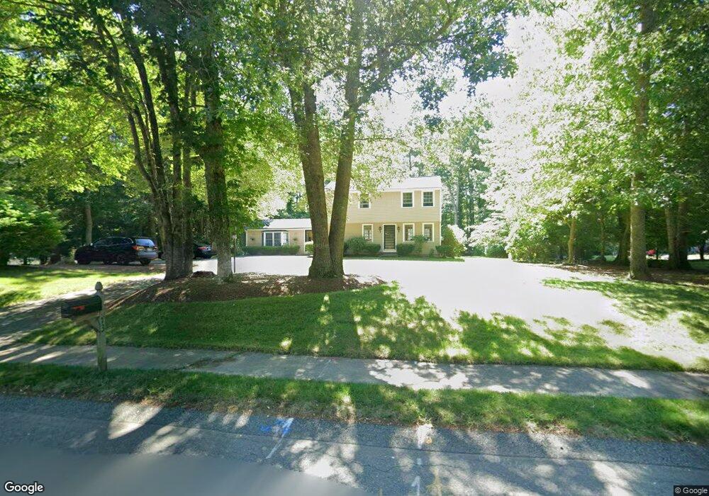
73 Juniper Ln Pembroke, MA 02359
Estimated Value: $737,994 - $843,000
4
Beds
3
Baths
2,048
Sq Ft
$388/Sq Ft
Est. Value
About This Home
This home is located at 73 Juniper Ln, Pembroke, MA 02359 and is currently estimated at $794,499, approximately $387 per square foot. 73 Juniper Ln is a home located in Plymouth County with nearby schools including Pembroke High School, Cadence Academy Preschool - Hanover, and Cardinal Cushing Centers.
Ownership History
Date
Name
Owned For
Owner Type
Purchase Details
Closed on
Dec 30, 2024
Sold by
Capuzzo John F and Capuzzo Mary E
Bought by
Mary & John Capuzzo Ret
Current Estimated Value
Purchase Details
Closed on
Aug 23, 1996
Sold by
Farrell Robert K and Farrell Ruth A
Bought by
Capuzzo John F and Capuzzo Mary E
Create a Home Valuation Report for This Property
The Home Valuation Report is an in-depth analysis detailing your home's value as well as a comparison with similar homes in the area
Purchase History
| Date | Buyer | Sale Price | Title Company |
|---|---|---|---|
| Mary & John Capuzzo Ret | -- | None Available | |
| Mary & John Capuzzo Ret | -- | None Available | |
| Capuzzo John F | $189,900 | -- | |
| Capuzzo John F | $189,900 | -- |
Source: Public Records
Mortgage History
| Date | Status | Borrower | Loan Amount |
|---|---|---|---|
| Previous Owner | Capuzzo John F | $125,000 | |
| Previous Owner | Capuzzo John F | $132,000 | |
| Previous Owner | Capuzzo John F | $120,000 |
Source: Public Records
Tax History
| Year | Tax Paid | Tax Assessment Tax Assessment Total Assessment is a certain percentage of the fair market value that is determined by local assessors to be the total taxable value of land and additions on the property. | Land | Improvement |
|---|---|---|---|---|
| 2025 | $7,857 | $653,700 | $325,200 | $328,500 |
| 2024 | $7,764 | $645,400 | $320,000 | $325,400 |
| 2023 | $7,345 | $577,400 | $295,200 | $282,200 |
| 2022 | $6,864 | $485,100 | $235,200 | $249,900 |
| 2021 | $6,751 | $463,000 | $230,000 | $233,000 |
| 2020 | $6,652 | $459,100 | $230,000 | $229,100 |
| 2019 | $6,398 | $438,200 | $220,000 | $218,200 |
| 2018 | $6,281 | $421,800 | $220,000 | $201,800 |
| 2017 | $5,866 | $388,500 | $205,200 | $183,300 |
| 2016 | $5,770 | $378,100 | $195,200 | $182,900 |
| 2015 | $5,442 | $369,200 | $185,200 | $184,000 |
Source: Public Records
Map
Nearby Homes
- 58 Bagnell Dr Unit 58
- 30 Old Washington St Unit 9
- 99 Old Washington St
- 7 Spring St
- 33 Barker Square Dr Unit 33
- 8 Quaker Cir
- 148 High St
- 12 Herring Brook Ln
- 695 Keene St
- 77 Old Cart Path Ln Unit Lot 4
- 78 Old Cart Path Ln Unit Lot 3
- 261 Washington St
- 387 North St
- 72 Old Cart Path Ln Unit Lot 2
- 172 Washington St
- 6 Hillside Ln
- 676 Franklin St
- 2 Secret Pond Way Unit 35
- 1 Secret Pond Way Unit 36
- 3 Harlow Brook Way Unit 3
Your Personal Tour Guide
Ask me questions while you tour the home.