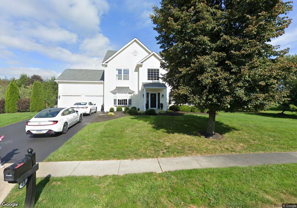
73 Kulp Rd W Chalfont, PA 18914
Estimated Value: $799,098 - $879,000
4
Beds
3
Baths
2,678
Sq Ft
$319/Sq Ft
Est. Value
About This Home
This home is located at 73 Kulp Rd W, Chalfont, PA 18914 and is currently estimated at $853,525, approximately $318 per square foot. 73 Kulp Rd W is a home located in Bucks County with nearby schools including Mill Creek Elementary School, Unami Middle School, and Central Bucks High School - South.
Ownership History
Date
Name
Owned For
Owner Type
Purchase Details
Closed on
Dec 17, 2004
Sold by
Patel Praful
Bought by
Burke Jeffrey and Burke Gail
Current Estimated Value
Home Financials for this Owner
Home Financials are based on the most recent Mortgage that was taken out on this home.
Original Mortgage
$396,000
Interest Rate
1.75%
Mortgage Type
New Conventional
Purchase Details
Closed on
Dec 9, 1999
Sold by
The Cutler Group Inc
Bought by
Coe Kelvin R and Coe Jacqueline M
Home Financials for this Owner
Home Financials are based on the most recent Mortgage that was taken out on this home.
Original Mortgage
$208,430
Interest Rate
7.5%
Create a Home Valuation Report for This Property
The Home Valuation Report is an in-depth analysis detailing your home's value as well as a comparison with similar homes in the area
Home Values in the Area
Average Home Value in this Area
Purchase History
| Date | Buyer | Sale Price | Title Company |
|---|---|---|---|
| Burke Jeffrey | $495,000 | -- | |
| Coe Kelvin R | $260,540 | First American Title Ins Co |
Source: Public Records
Mortgage History
| Date | Status | Borrower | Loan Amount |
|---|---|---|---|
| Open | Burke Jeffrey | $49,500 | |
| Previous Owner | Burke Jeffrey | $396,000 | |
| Previous Owner | Coe Kelvin R | $208,430 | |
| Closed | Coe Kelvin R | $26,050 |
Source: Public Records
Tax History Compared to Growth
Tax History
| Year | Tax Paid | Tax Assessment Tax Assessment Total Assessment is a certain percentage of the fair market value that is determined by local assessors to be the total taxable value of land and additions on the property. | Land | Improvement |
|---|---|---|---|---|
| 2025 | $8,056 | $43,640 | $9,120 | $34,520 |
| 2024 | $8,056 | $43,640 | $9,120 | $34,520 |
| 2023 | $7,459 | $43,640 | $9,120 | $34,520 |
| 2022 | $7,311 | $43,640 | $9,120 | $34,520 |
| 2021 | $7,230 | $43,640 | $9,120 | $34,520 |
| 2020 | $7,230 | $43,640 | $9,120 | $34,520 |
| 2019 | $7,186 | $43,640 | $9,120 | $34,520 |
| 2018 | $7,106 | $43,640 | $9,120 | $34,520 |
| 2017 | $7,010 | $43,640 | $9,120 | $34,520 |
| 2016 | $6,989 | $43,640 | $9,120 | $34,520 |
| 2015 | -- | $43,640 | $9,120 | $34,520 |
| 2014 | -- | $43,640 | $9,120 | $34,520 |
Source: Public Records
Map
Nearby Homes
- 3000 Tyler Way
- 1805 Regency Ct Unit 146
- 511 McNaney Farm Dr Lot #6
- 3220 Wier Dr W Unit W
- 528 Fullerton Farm Ct
- 506 McNaney Farm Dr Lot # 27
- 506 Fullerton Farm Court Lot #22
- 503
- 508 Fullerton Farm Court Lot#21
- 204 Neighbors Rd
- 625 N Settlers Cir
- 222 Grove Valley Ct
- 214 Grove Valley Ct
- 407 Maryjoe Way
- 1608 County Line Rd
- 1231 Lower State Rd
- 430 Homestead Cir
- 623 Addison Way
- 87 Schreiner Dr
- 2627 County Line Rd