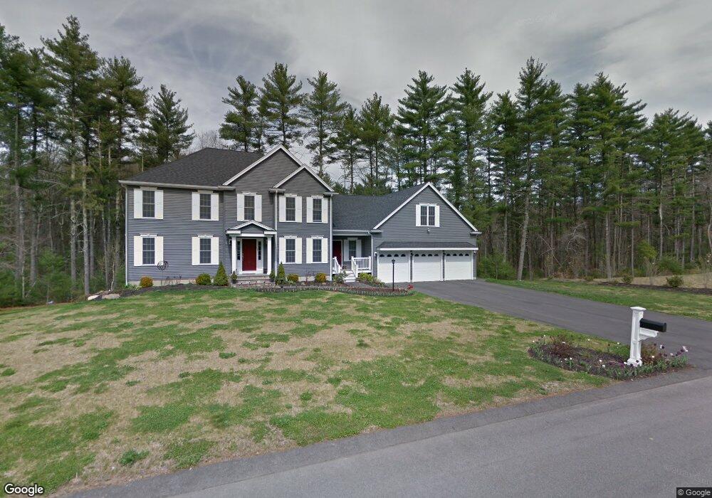
73 Libby Ln Taunton, MA 02780
Whittenton Junction NeighborhoodEstimated Value: $721,955 - $892,000
4
Beds
3
Baths
2,700
Sq Ft
$296/Sq Ft
Est. Value
About This Home
This home is located at 73 Libby Ln, Taunton, MA 02780 and is currently estimated at $800,239, approximately $296 per square foot. 73 Libby Ln is a home located in Bristol County with nearby schools including Benjamin Friedman Middle School, Joseph C. Chamberlain Elementary School, and Taunton High School.
Ownership History
Date
Name
Owned For
Owner Type
Purchase Details
Closed on
Mar 4, 2013
Sold by
Caldwell Craig L and Mazza Robert C
Bought by
Mazza Caldwell Nt
Current Estimated Value
Purchase Details
Closed on
Mar 29, 2011
Sold by
Yvon Nadcau Dev Co Inc
Bought by
Caldwell Craig L and Mazza Robert C
Home Financials for this Owner
Home Financials are based on the most recent Mortgage that was taken out on this home.
Original Mortgage
$368,000
Interest Rate
4%
Mortgage Type
Purchase Money Mortgage
Purchase Details
Closed on
Feb 3, 2006
Sold by
Yvon Nadeau Dev Co
Bought by
Gateway Bldrs Rt
Home Financials for this Owner
Home Financials are based on the most recent Mortgage that was taken out on this home.
Original Mortgage
$360,000
Interest Rate
6.31%
Mortgage Type
Purchase Money Mortgage
Create a Home Valuation Report for This Property
The Home Valuation Report is an in-depth analysis detailing your home's value as well as a comparison with similar homes in the area
Home Values in the Area
Average Home Value in this Area
Purchase History
| Date | Buyer | Sale Price | Title Company |
|---|---|---|---|
| Mazza Caldwell Nt | -- | -- | |
| Caldwell Craig L | $419,500 | -- | |
| Gateway Bldrs Rt | $175,000 | -- |
Source: Public Records
Mortgage History
| Date | Status | Borrower | Loan Amount |
|---|---|---|---|
| Previous Owner | Caldwell Craig L | $368,000 | |
| Previous Owner | Gateway Bldrs Rt | $360,000 |
Source: Public Records
Tax History Compared to Growth
Tax History
| Year | Tax Paid | Tax Assessment Tax Assessment Total Assessment is a certain percentage of the fair market value that is determined by local assessors to be the total taxable value of land and additions on the property. | Land | Improvement |
|---|---|---|---|---|
| 2025 | $7,344 | $671,300 | $151,700 | $519,600 |
| 2024 | $7,144 | $638,400 | $171,500 | $466,900 |
| 2023 | $7,079 | $587,500 | $171,500 | $416,000 |
| 2022 | $6,825 | $517,800 | $149,500 | $368,300 |
| 2021 | $7,179 | $472,200 | $131,500 | $340,700 |
| 2020 | $6,732 | $440,800 | $131,500 | $309,300 |
| 2019 | $6,493 | $442,300 | $144,100 | $298,200 |
| 2018 | $6,804 | $432,800 | $145,400 | $287,400 |
| 2017 | $6,528 | $415,500 | $138,600 | $276,900 |
| 2016 | $6,410 | $408,800 | $134,500 | $274,300 |
| 2015 | $5,855 | $390,100 | $111,000 | $279,100 |
| 2014 | $5,771 | $395,000 | $111,000 | $284,000 |
Source: Public Records
Map
Nearby Homes
- Lot 8 Joel Harvey Way
- 3 Jeffrey Ln
- 588 Crane Ave S
- 198 Taunton Ave Unit B
- 198 Taunton Ave Unit A
- 196 Taunton Ave Unit B
- 46 Pondview Cir
- 25 Wintergreen Ln
- 80 Short St
- 90 Mello Dr
- 115 Ice House Rd
- 50 Rosewood Dr
- 4 John Scott Blvd
- 5 John Scott Blvd
- 152 Pine St Unit 23
- 260 S Washington St
- 94 Sycamore Ln
- Continental Plan at Wheelock Farm
- Hardwick Plan at Wheelock Farm
- Abbeyville Plan at Wheelock Farm