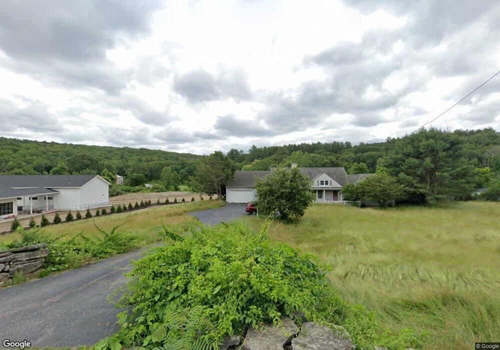
73 Mccracken Rd Millbury, MA 01527
Estimated Value: $643,000 - $765,000
3
Beds
4
Baths
2,582
Sq Ft
$263/Sq Ft
Est. Value
About This Home
This home is located at 73 Mccracken Rd, Millbury, MA 01527 and is currently estimated at $679,198, approximately $263 per square foot. 73 Mccracken Rd is a home located in Worcester County with nearby schools including Elmwood Street Elementary School, Raymond E. Shaw Elementary School, and Millbury Junior/Senior High School.
Ownership History
Date
Name
Owned For
Owner Type
Purchase Details
Closed on
Aug 14, 2025
Sold by
Dream 6 Llc
Bought by
Boiquaye Samuel
Current Estimated Value
Home Financials for this Owner
Home Financials are based on the most recent Mortgage that was taken out on this home.
Original Mortgage
$508,000
Outstanding Balance
$507,556
Interest Rate
6.67%
Mortgage Type
New Conventional
Estimated Equity
$171,642
Purchase Details
Closed on
Nov 15, 2024
Sold by
Boiquaye Samuel
Bought by
Dream 6 Llc
Home Financials for this Owner
Home Financials are based on the most recent Mortgage that was taken out on this home.
Original Mortgage
$529,000
Interest Rate
6.12%
Mortgage Type
Commercial
Purchase Details
Closed on
Oct 22, 2024
Sold by
Catullo Julie A and Citizens Bank Na
Bought by
Boiquaye Samuel
Home Financials for this Owner
Home Financials are based on the most recent Mortgage that was taken out on this home.
Original Mortgage
$529,000
Interest Rate
6.12%
Mortgage Type
Commercial
Purchase Details
Closed on
Jan 15, 2014
Sold by
Penny David J and Catullo Julie A
Bought by
Catullo Julie A
Purchase Details
Closed on
Apr 6, 2009
Sold by
Allaire Donald G and Allaire Kathy P
Bought by
Catullo Julie A and Penny David J
Home Financials for this Owner
Home Financials are based on the most recent Mortgage that was taken out on this home.
Original Mortgage
$288,000
Interest Rate
4.92%
Mortgage Type
Purchase Money Mortgage
Purchase Details
Closed on
Jul 15, 1998
Sold by
Allaire George H and Allaire Lorenette E
Bought by
Allaire Donald G and Allaire Kathy P
Purchase Details
Closed on
Sep 22, 1993
Sold by
Allaire Albert E Est and Shawmut Bank
Bought by
Allaire George H
Create a Home Valuation Report for This Property
The Home Valuation Report is an in-depth analysis detailing your home's value as well as a comparison with similar homes in the area
Home Values in the Area
Average Home Value in this Area
Purchase History
| Date | Buyer | Sale Price | Title Company |
|---|---|---|---|
| Boiquaye Samuel | -- | -- | |
| Boiquaye Samuel | -- | -- | |
| Dream 6 Llc | -- | None Available | |
| Dream 6 Llc | -- | None Available | |
| Dream 6 Llc | -- | None Available | |
| Boiquaye Samuel | $456,000 | None Available | |
| Boiquaye Samuel | $456,000 | None Available | |
| Boiquaye Samuel | $456,000 | None Available | |
| Catullo Julie A | -- | -- | |
| Catullo Julie A | $360,000 | -- | |
| Catullo Julie A | $360,000 | -- | |
| Allaire Donald G | $225,000 | -- | |
| Allaire George H | $235,000 | -- | |
| Catullo Julie A | -- | -- | |
| Catullo Julie A | $360,000 | -- | |
| Allaire Donald G | $225,000 | -- | |
| Allaire George H | $235,000 | -- |
Source: Public Records
Mortgage History
| Date | Status | Borrower | Loan Amount |
|---|---|---|---|
| Open | Boiquaye Samuel | $508,000 | |
| Closed | Boiquaye Samuel | $508,000 | |
| Previous Owner | Dream 6 Llc | $529,000 | |
| Previous Owner | Catullo Julie A | $288,000 |
Source: Public Records
Tax History Compared to Growth
Tax History
| Year | Tax Paid | Tax Assessment Tax Assessment Total Assessment is a certain percentage of the fair market value that is determined by local assessors to be the total taxable value of land and additions on the property. | Land | Improvement |
|---|---|---|---|---|
| 2025 | $7,144 | $533,500 | $137,400 | $396,100 |
| 2024 | $6,571 | $496,700 | $127,300 | $369,400 |
| 2023 | $6,034 | $417,600 | $89,300 | $328,300 |
| 2022 | $5,853 | $390,200 | $89,300 | $300,900 |
| 2021 | $5,732 | $371,500 | $89,300 | $282,200 |
| 2020 | $9,378 | $362,200 | $89,300 | $272,900 |
| 2019 | $5,581 | $352,100 | $88,800 | $263,300 |
| 2018 | $1,313 | $416,600 | $88,800 | $327,800 |
| 2017 | $5,780 | $351,800 | $88,800 | $263,000 |
| 2016 | $5,305 | $322,300 | $88,800 | $233,500 |
| 2015 | $5,234 | $318,000 | $90,200 | $227,800 |
| 2014 | $5,168 | $302,200 | $94,300 | $207,900 |
Source: Public Records
Map
Nearby Homes
- 33 Tainter Hill Rd Unit 33B
- 14 Auburn Rd
- 557 SW Cutoff Unit 79
- 557 SW Cutoff Unit 107
- 557 SW Cutoff Unit 17
- 5- 33 Tainter Hill Rd Unit 33A
- 5- 33 Tainter Hill Rd
- 47 Washington St Unit 26
- 0 Auburn Rd
- 24 Upper Windbrook
- 2 Breezy Bend
- 3 Lower Windbrook Dr
- 55 Old Common Rd
- 2 Camden Dr
- 15 Clearview Terrace Unit 68
- 90 Park Hill Ave
- 1295 Millbury St Unit B
- 32 Horne Way
- 2 Victoria Dr Unit 1
- 52 Clearview Terrace Unit 39
- 73 Mccracken Rd
- 73 Mccracken Rd
- 75 Mccracken Rd
- 71 & 73 Mccracken Rd
- 71 Mccracken Rd
- 76 Mccracken Rd
- 0 Dwinell Rd
- B Dwinell Rd
- A Dwinell Rd
- 69 Mccracken Rd
- 55 Dwinell Rd
- Lot B Dwinell Rd
- 67 Mccracken Rd
- 53 Dwinell Rd
- 80 Mccracken Rd
- 68 Mccracken Rd
- 52 Dwinell Rd
- 65 Mccracken Rd
- 87 Mccracken Rd
- 82 Mccracken Rd