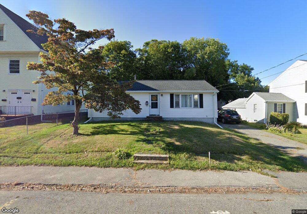
73 Orchard St Taunton, MA 02780
Estimated Value: $346,000 - $453,000
2
Beds
1
Bath
1,000
Sq Ft
$401/Sq Ft
Est. Value
About This Home
This home is located at 73 Orchard St, Taunton, MA 02780 and is currently estimated at $401,092, approximately $401 per square foot. 73 Orchard St is a home located in Bristol County with nearby schools including Mulcahey Elementary School, Taunton High School, and John F. Parker Middle School.
Ownership History
Date
Name
Owned For
Owner Type
Purchase Details
Closed on
Nov 19, 2010
Sold by
Fnma
Bought by
Desousa Paul and Desousa Sandra
Current Estimated Value
Home Financials for this Owner
Home Financials are based on the most recent Mortgage that was taken out on this home.
Original Mortgage
$102,400
Outstanding Balance
$67,665
Interest Rate
4.3%
Mortgage Type
Purchase Money Mortgage
Estimated Equity
$333,427
Purchase Details
Closed on
May 27, 2010
Sold by
Mhfa
Bought by
Federal National Mortgage Association
Purchase Details
Closed on
Apr 23, 2010
Sold by
Malaguti Lisa and Platt Brain
Bought by
Mhfa
Purchase Details
Closed on
Oct 27, 2006
Sold by
Fv 1 Inc
Bought by
Platt Brian and Malaguti Lisa
Home Financials for this Owner
Home Financials are based on the most recent Mortgage that was taken out on this home.
Original Mortgage
$225,000
Interest Rate
6.48%
Mortgage Type
Purchase Money Mortgage
Purchase Details
Closed on
Sep 1, 2005
Sold by
Mtg Elec Registration and Dearing
Bought by
Mtg Elec Registration
Purchase Details
Closed on
Feb 23, 2004
Sold by
Magras Randolph L and Magras Vassiliki
Bought by
Dearing Kevin J
Home Financials for this Owner
Home Financials are based on the most recent Mortgage that was taken out on this home.
Original Mortgage
$180,000
Interest Rate
5.83%
Mortgage Type
Purchase Money Mortgage
Purchase Details
Closed on
Aug 3, 2001
Sold by
Smith Shawn P and Smith Susan R
Bought by
Magras Randolph L and Magras Vassiliki
Home Financials for this Owner
Home Financials are based on the most recent Mortgage that was taken out on this home.
Original Mortgage
$144,637
Interest Rate
7.14%
Mortgage Type
Purchase Money Mortgage
Purchase Details
Closed on
Nov 2, 1998
Sold by
Latham Eleanor H and Obrien Helen M
Bought by
Smith Shawn P and Smith Susan R
Home Financials for this Owner
Home Financials are based on the most recent Mortgage that was taken out on this home.
Original Mortgage
$86,400
Interest Rate
6.68%
Mortgage Type
Purchase Money Mortgage
Create a Home Valuation Report for This Property
The Home Valuation Report is an in-depth analysis detailing your home's value as well as a comparison with similar homes in the area
Home Values in the Area
Average Home Value in this Area
Purchase History
| Date | Buyer | Sale Price | Title Company |
|---|---|---|---|
| Desousa Paul | $128,000 | -- | |
| Federal National Mortgage Association | -- | -- | |
| Mhfa | $209,198 | -- | |
| Platt Brian | $225,000 | -- | |
| Mtg Elec Registration | $185,000 | -- | |
| Dearing Kevin J | $225,000 | -- | |
| Magras Randolph L | $150,000 | -- | |
| Smith Shawn P | $96,000 | -- |
Source: Public Records
Mortgage History
| Date | Status | Borrower | Loan Amount |
|---|---|---|---|
| Open | Desousa Paul | $102,400 | |
| Previous Owner | Platt Brian | $225,000 | |
| Previous Owner | Dearing Kevin J | $180,000 | |
| Previous Owner | Smith Shawn P | $144,637 | |
| Previous Owner | Smith Shawn P | $86,400 |
Source: Public Records
Tax History Compared to Growth
Tax History
| Year | Tax Paid | Tax Assessment Tax Assessment Total Assessment is a certain percentage of the fair market value that is determined by local assessors to be the total taxable value of land and additions on the property. | Land | Improvement |
|---|---|---|---|---|
| 2025 | $3,538 | $323,400 | $96,100 | $227,300 |
| 2024 | $3,298 | $294,700 | $96,100 | $198,600 |
| 2023 | $3,338 | $277,000 | $96,100 | $180,900 |
| 2022 | $3,187 | $241,800 | $80,100 | $161,700 |
| 2021 | $3,020 | $212,700 | $72,800 | $139,900 |
| 2020 | $2,997 | $201,700 | $72,800 | $128,900 |
| 2019 | $3,027 | $192,100 | $72,800 | $119,300 |
| 2018 | $2,776 | $176,600 | $72,600 | $104,000 |
| 2017 | $2,674 | $170,200 | $68,800 | $101,400 |
| 2016 | $2,575 | $164,200 | $66,800 | $97,400 |
| 2015 | $2,495 | $166,200 | $67,500 | $98,700 |
| 2014 | $2,349 | $160,800 | $64,700 | $96,100 |
Source: Public Records
Map
Nearby Homes
- 22 Everett St
- 72 Barnum St
- 16 Clinton St
- 278 Cohannet St
- 132 Winthrop St
- 98 Winthrop St
- 56 Silver St
- 252 Somerset Ave
- 4 Parkin Ct
- 46 Harrison St Unit 4
- 24 1st St
- 19 Mason St
- 39 Myrtle St
- 450 Somerset Ave Unit 2-7
- 450 Somerset Ave Unit 6-6
- 193 Winthrop St
- 215 High St Unit 21
- 215 High St Unit 20
- 125 Highland St Unit 103
- 48 Oak St
- 77 Orchard St
- 75 Orchard St
- 59 Orchard St
- 59 Orchard St Unit 1R
- 59 Orchard St Unit 2
- 63 Clinton St
- 34 W Weir St
- 74 Orchard St Unit 1
- 74 Orchard St Unit 2
- 74 Orchard St
- 32 W Weir St
- 32 W Weir St Unit 2nd fl
- 72 Orchard St
- 72 Orchard St Unit 1
- 72 Orchard St Unit 72
- 76 Orchard St
- 70 Orchard St
- 30 W Weir St
- 53 Clinton St
- 53 Orchard St