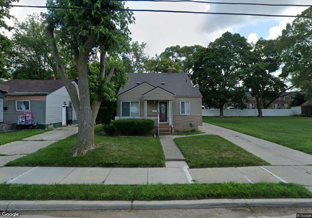
73 S Marshall St Pontiac, MI 48342
Estimated Value: $112,000 - $172,000
3
Beds
1
Bath
1,015
Sq Ft
$140/Sq Ft
Est. Value
About This Home
This home is located at 73 S Marshall St, Pontiac, MI 48342 and is currently estimated at $142,160, approximately $140 per square foot. 73 S Marshall St is a home located in Oakland County with nearby schools including Walt Whitman Elementary School, Pontiac Middle School, and Pontiac High School.
Ownership History
Date
Name
Owned For
Owner Type
Purchase Details
Closed on
Dec 29, 2008
Sold by
Landry Edward
Bought by
Landry Adonica L
Current Estimated Value
Purchase Details
Closed on
Feb 27, 2007
Sold by
Landry Edward and Landry Adonica L
Bought by
Us Bank Na
Purchase Details
Closed on
Feb 10, 1999
Sold by
Downing Joan T
Bought by
Landry Edward
Purchase Details
Closed on
Aug 28, 1998
Sold by
Household Bank
Bought by
Downing Joan T
Purchase Details
Closed on
Nov 4, 1997
Sold by
Benson Betty J
Bought by
Household Bank
Create a Home Valuation Report for This Property
The Home Valuation Report is an in-depth analysis detailing your home's value as well as a comparison with similar homes in the area
Home Values in the Area
Average Home Value in this Area
Purchase History
| Date | Buyer | Sale Price | Title Company |
|---|---|---|---|
| Landry Adonica L | -- | None Available | |
| Us Bank Na | $80,750 | None Available | |
| Landry Edward | $64,900 | -- | |
| Downing Joan T | $15,000 | -- | |
| Household Bank | $47,840 | -- |
Source: Public Records
Tax History Compared to Growth
Tax History
| Year | Tax Paid | Tax Assessment Tax Assessment Total Assessment is a certain percentage of the fair market value that is determined by local assessors to be the total taxable value of land and additions on the property. | Land | Improvement |
|---|---|---|---|---|
| 2024 | $710 | $37,190 | $0 | $0 |
| 2023 | $677 | $32,910 | $0 | $0 |
| 2022 | $720 | $28,890 | $0 | $0 |
| 2021 | $700 | $27,540 | $0 | $0 |
| 2020 | $615 | $25,120 | $0 | $0 |
| 2019 | $674 | $22,210 | $0 | $0 |
| 2018 | $643 | $20,400 | $0 | $0 |
| 2017 | $597 | $19,300 | $0 | $0 |
| 2016 | $624 | $18,730 | $0 | $0 |
| 2015 | -- | $17,240 | $0 | $0 |
| 2014 | -- | $14,940 | $0 | $0 |
| 2011 | -- | $20,390 | $0 | $0 |
Source: Public Records
Map
Nearby Homes
- 28 S Marshall St
- 505 Auburn Ave
- 46 N Anderson Ave
- 511 E Pike St
- 176 S Francis Ave
- 717 E Pike St
- 33 S Tasmania St
- 291 Michigan Ave
- 88 N Astor St
- 53 N Midland Dr
- 18 S Shirley St
- 328 Whittemore St
- 389 Osmun St
- 53 N Roselawn St
- 55 N Roselawn St
- 57 N Roselawn St
- 70 N Roselawn St
- 187 Wall St
- 97 N Roselawn St
- 59 Bellevue St
- 69 S Marshall St
- 77 S Marshall St
- 65 S Marshall St
- 72 S Marshall St
- 64 Ml King jr Blvd S
- 70 S Marshall St
- 78 S Marshall St
- 64 S Marshall St
- 93 S Marshall St
- 88 Martin Luther King jr Blvd S Unit Bldg-Unit
- 94 Martin Luther King jr Blvd S
- 90 Martin Luther King jr Blvd S
- 88 Martin Luther King jr Blvd S
- 86 Martin Luther King jr Blvd S
- 78 Martin Luther King jr Blvd S
- 84 Martin Luther King jr Blvd S
- 82 Martin Luther King jr Blvd S
- 98 Martin Luther King jr Blvd S
- 78 Martin Luther King jr Blvd S
- 51 S Marshall St