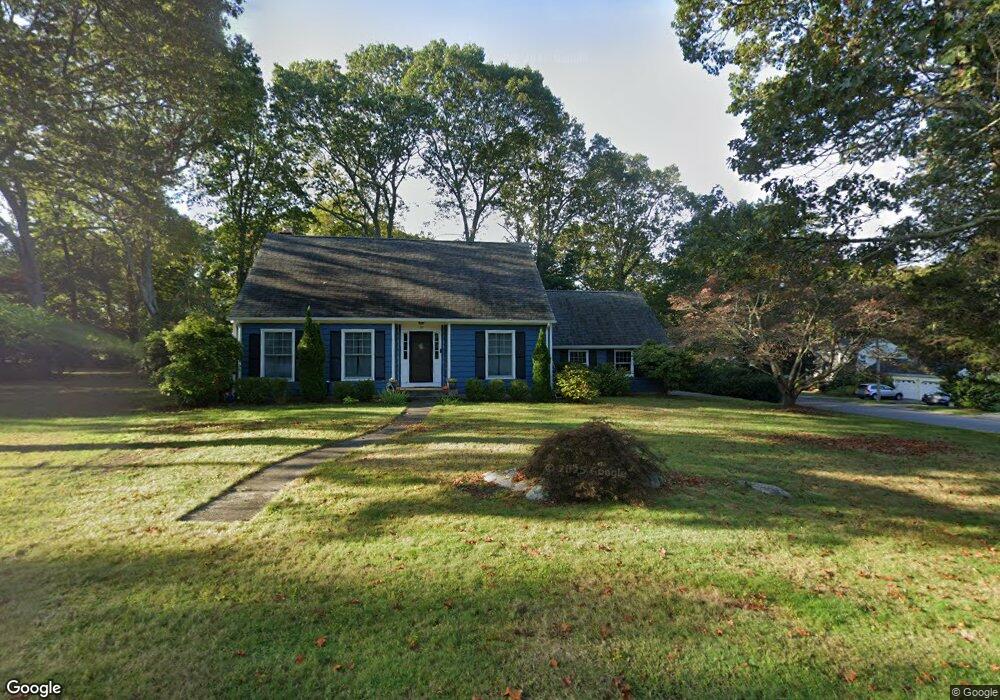
73 Stonecrest Rd Groton, CT 06340
Estimated Value: $500,000 - $700,000
3
Beds
7
Baths
2,292
Sq Ft
$268/Sq Ft
Est. Value
About This Home
This home is located at 73 Stonecrest Rd, Groton, CT 06340 and is currently estimated at $614,484, approximately $268 per square foot. 73 Stonecrest Rd is a home located in New London County with nearby schools including Groton Middle School and Robert E. Fitch High School.
Ownership History
Date
Name
Owned For
Owner Type
Purchase Details
Closed on
Dec 16, 2008
Sold by
Harms John F and Harms Deborah D
Bought by
Torres Alberto E and Torres Tracy L
Current Estimated Value
Home Financials for this Owner
Home Financials are based on the most recent Mortgage that was taken out on this home.
Original Mortgage
$315,000
Outstanding Balance
$211,763
Interest Rate
6.49%
Estimated Equity
$402,722
Purchase Details
Closed on
Feb 22, 2005
Sold by
Glazier William
Bought by
Harms John and Harms Deborah
Home Financials for this Owner
Home Financials are based on the most recent Mortgage that was taken out on this home.
Original Mortgage
$180,000
Interest Rate
5.78%
Create a Home Valuation Report for This Property
The Home Valuation Report is an in-depth analysis detailing your home's value as well as a comparison with similar homes in the area
Home Values in the Area
Average Home Value in this Area
Purchase History
| Date | Buyer | Sale Price | Title Company |
|---|---|---|---|
| Torres Alberto E | $350,000 | -- | |
| Harms John | $400,000 | -- |
Source: Public Records
Mortgage History
| Date | Status | Borrower | Loan Amount |
|---|---|---|---|
| Open | Harms John | $315,000 | |
| Previous Owner | Harms John | $180,000 | |
| Previous Owner | Harms John | $90,000 | |
| Previous Owner | Harms John | $100,000 |
Source: Public Records
Tax History Compared to Growth
Tax History
| Year | Tax Paid | Tax Assessment Tax Assessment Total Assessment is a certain percentage of the fair market value that is determined by local assessors to be the total taxable value of land and additions on the property. | Land | Improvement |
|---|---|---|---|---|
| 2025 | $7,645 | $259,070 | $102,760 | $156,310 |
| 2024 | $7,197 | $259,070 | $102,760 | $156,310 |
| 2023 | $7,054 | $259,070 | $35,770 | $223,300 |
| 2022 | $6,891 | $259,070 | $35,770 | $223,300 |
| 2021 | $6,364 | $196,000 | $35,770 | $160,230 |
| 2020 | $6,198 | $196,000 | $35,770 | $160,230 |
| 2019 | $5,968 | $196,000 | $35,770 | $160,230 |
| 2018 | $5,907 | $196,000 | $35,770 | $160,230 |
| 2017 | $5,755 | $196,000 | $35,770 | $160,230 |
| 2016 | $5,702 | $203,070 | $55,440 | $147,630 |
| 2015 | $5,483 | $203,070 | $55,440 | $147,630 |
| 2014 | $5,337 | $203,070 | $55,440 | $147,630 |
Source: Public Records
Map
Nearby Homes
- 103 Flanders Rd
- 95 Flanders Rd
- 17 Brookside Ln
- 3 Fort Hill Rd
- 30 Midway Oval
- 295 Midway Oval
- 75 Midway Oval
- 80 Farmstead Ave
- 18 Tacoma Ct
- 201 Daniel Brown Dr
- 147 Midway Oval
- 106 Midway Oval
- 190 Judson Ave
- 233 High Meadow Ln
- 518 Noank Ledyard Rd
- 26 Charles St
- 224 Neptune Dr
- 130 Ocean View Ave
- 44 Brook St
- 144 Warren Ave
- 30 Hemlock Rd
- 21 Stonecrest Rd
- 47 Hemlock Rd
- 37 Hemlock Rd
- 52 Stonecrest Rd
- 74 Stonecrest Rd
- 65 Hemlock Rd
- 42 Stonecrest Rd
- 66 Stonecrest Rd
- 25 Hemlock Rd
- 10 Hemlock Rd
- 30 Stonecrest Rd
- 40 Lemont Rd
- 15 Hemlock Rd
- 15 Stonecrest Rd
- 81 Hemlock Rd
- 75 Hemlock Rd Unit 77
- 18 Stonecrest Rd
- 5 Hemlock Rd
- 152 New London Rd