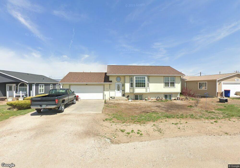
730 1st St Bennett, CO 80102
Estimated Value: $430,000 - $667,000
3
Beds
2
Baths
2,132
Sq Ft
$235/Sq Ft
Est. Value
About This Home
This home is located at 730 1st St, Bennett, CO 80102 and is currently estimated at $501,514, approximately $235 per square foot. 730 1st St is a home located in Adams County with nearby schools including Bennett Elementary School, Bennett Middle School, and Bennett High School.
Ownership History
Date
Name
Owned For
Owner Type
Purchase Details
Closed on
Oct 31, 1997
Sold by
Parr Scott A and Parr Susan K
Bought by
Harrison Russell and Harrison Cheryl
Current Estimated Value
Home Financials for this Owner
Home Financials are based on the most recent Mortgage that was taken out on this home.
Original Mortgage
$80,000
Outstanding Balance
$11,231
Interest Rate
7.27%
Estimated Equity
$490,283
Purchase Details
Closed on
Jan 26, 1996
Sold by
Moler Greg D
Bought by
Parr Scott A and Parr Susan K
Home Financials for this Owner
Home Financials are based on the most recent Mortgage that was taken out on this home.
Original Mortgage
$104,652
Interest Rate
7.19%
Mortgage Type
FHA
Purchase Details
Closed on
Oct 15, 1993
Sold by
Barton Bros Inc
Bought by
Delcamp Michael L and Delcamp Raymond L
Create a Home Valuation Report for This Property
The Home Valuation Report is an in-depth analysis detailing your home's value as well as a comparison with similar homes in the area
Purchase History
| Date | Buyer | Sale Price | Title Company |
|---|---|---|---|
| Harrison Russell | $126,900 | -- | |
| Parr Scott A | $106,500 | First American Heritage Titl | |
| Delcamp Michael L | $5,000 | -- |
Source: Public Records
Mortgage History
| Date | Status | Borrower | Loan Amount |
|---|---|---|---|
| Open | Harrison Russell | $80,000 | |
| Previous Owner | Parr Scott A | $104,652 |
Source: Public Records
Tax History
| Year | Tax Paid | Tax Assessment Tax Assessment Total Assessment is a certain percentage of the fair market value that is determined by local assessors to be the total taxable value of land and additions on the property. | Land | Improvement |
|---|---|---|---|---|
| 2025 | $2,284 | $27,750 | $5,920 | $21,830 |
| 2024 | $2,284 | $25,500 | $5,440 | $20,060 |
| 2023 | $2,299 | $30,570 | $5,340 | $25,230 |
| 2022 | $1,960 | $22,750 | $5,490 | $17,260 |
| 2021 | $2,000 | $22,750 | $5,490 | $17,260 |
| 2020 | $1,957 | $23,230 | $5,650 | $17,580 |
| 2019 | $2,009 | $23,230 | $5,650 | $17,580 |
| 2018 | $1,704 | $17,910 | $2,810 | $15,100 |
| 2017 | $1,719 | $17,910 | $2,810 | $15,100 |
| 2016 | $1,300 | $14,030 | $3,100 | $10,930 |
| 2015 | $1,294 | $14,030 | $3,100 | $10,930 |
| 2014 | $1,123 | $12,020 | $2,310 | $9,710 |
Source: Public Records
Map
Nearby Homes
- 575 2nd St
- 574 4th St
- 610 6th St
- 0 Colorado 79
- 216 Ash St
- 704 Madison Way
- 210 Elm St
- 231 Dahlia St
- 271 Birch St
- 48165 Shetland Dr
- 48190 Shetland Dr
- 48200 Shetland Dr
- 48175 Shetland Dr
- 48215 Shetland Dr
- 48250 Shetland Dr
- 48240 Shetland Dr
- 48285 Shetland Dr
- 48210 Shetland Dr
- 48295 Shetland Dr
- 48245 Shetland Dr
Your Personal Tour Guide
Ask me questions while you tour the home.