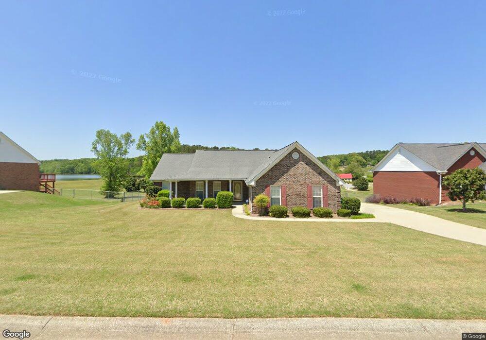
730 Mallard Dr Unit 1 Winder, GA 30680
Estimated Value: $344,661 - $365,000
--
Bed
2
Baths
1,758
Sq Ft
$203/Sq Ft
Est. Value
About This Home
This home is located at 730 Mallard Dr Unit 1, Winder, GA 30680 and is currently estimated at $357,665, approximately $203 per square foot. 730 Mallard Dr Unit 1 is a home located in Barrow County with nearby schools including County Line Elementary School, Russell Middle School, and Winder-Barrow High School.
Ownership History
Date
Name
Owned For
Owner Type
Purchase Details
Closed on
May 2, 2005
Sold by
Gardner David L and Gardner Sharon
Bought by
Craig Dorthy S and Craig Leonard
Current Estimated Value
Purchase Details
Closed on
Nov 7, 2000
Sold by
Star Home Builders
Bought by
Gardner David L and Gardner Sharon G
Home Financials for this Owner
Home Financials are based on the most recent Mortgage that was taken out on this home.
Original Mortgage
$135,081
Interest Rate
7.71%
Mortgage Type
FHA
Create a Home Valuation Report for This Property
The Home Valuation Report is an in-depth analysis detailing your home's value as well as a comparison with similar homes in the area
Home Values in the Area
Average Home Value in this Area
Purchase History
| Date | Buyer | Sale Price | Title Company |
|---|---|---|---|
| Craig Dorthy S | $135,000 | -- | |
| Gardner David L | $135,200 | -- |
Source: Public Records
Mortgage History
| Date | Status | Borrower | Loan Amount |
|---|---|---|---|
| Previous Owner | Gardner David L | $135,081 |
Source: Public Records
Tax History Compared to Growth
Tax History
| Year | Tax Paid | Tax Assessment Tax Assessment Total Assessment is a certain percentage of the fair market value that is determined by local assessors to be the total taxable value of land and additions on the property. | Land | Improvement |
|---|---|---|---|---|
| 2024 | $1,620 | $119,832 | $28,000 | $91,832 |
| 2023 | $1,912 | $119,832 | $28,000 | $91,832 |
| 2022 | $903 | $72,569 | $16,400 | $56,169 |
| 2021 | $842 | $72,569 | $16,400 | $56,169 |
| 2020 | $782 | $67,922 | $16,400 | $51,522 |
| 2019 | $806 | $67,922 | $16,400 | $51,522 |
| 2018 | $758 | $62,074 | $15,200 | $46,874 |
| 2017 | $1,580 | $52,958 | $15,200 | $37,758 |
| 2016 | $1,151 | $51,503 | $15,200 | $36,303 |
| 2015 | $1,164 | $51,916 | $15,200 | $36,716 |
| 2014 | $396 | $43,576 | $6,860 | $36,716 |
| 2013 | -- | $41,273 | $6,860 | $34,413 |
Source: Public Records
Map
Nearby Homes
- 707 Overlook Dr Unit 1
- 469 Plantation Dr
- 381 W Candler St
- 553 Drake Cir
- 672 Meadowbrook Dr
- The Cary A Plan at Lake Shore
- The Marion A Plan at Lake Shore
- 401 N 5th Ave
- 642 Teal Dr
- 94 Garrison Dr
- 418 Jasmine Dr
- 254 Cedar Wood Trace
- 249 Cedar Wood Trace
- 240 Cedar Wood Trace
- 239 Cedar Wood Trace
- 121 Ashwood Dr
- 728 Mallard Dr
- 732 Mallard Dr Unit 24
- 732 Mallard Dr
- 726 Mallard Dr
- 729 Mallard Dr
- 731 Mallard Dr
- 734 Mallard Dr Unit 1
- 727 Mallard Dr Unit 1
- 725 Mallard Dr
- 724 Mallard Dr Unit 1
- 733 Mallard Dr
- 723 Mallard Dr Unit 24
- 723 Mallard Dr
- 722 Mallard Dr Unit I
- 708 High Point Dr
- 721 Mallard Dr
- 721 Mallard Dr Unit 1
- 720 Mallard Dr
- 706 High Point Dr
- 764 City Pond Rd