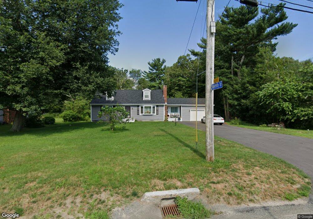
730 Sanford Rd Westport, MA 02790
North Westport NeighborhoodEstimated Value: $513,000 - $576,000
3
Beds
--
Bath
1,824
Sq Ft
$296/Sq Ft
Est. Value
About This Home
This home is located at 730 Sanford Rd, Westport, MA 02790 and is currently estimated at $540,557, approximately $296 per square foot. 730 Sanford Rd is a home located in Bristol County with nearby schools including Alice A. Macomber Primary School, Westport Elementary School, and Westport Middle-High School.
Ownership History
Date
Name
Owned For
Owner Type
Purchase Details
Closed on
Feb 20, 2009
Sold by
Morrissette Brian and Morrissette David
Bought by
Choquette Ronald
Current Estimated Value
Home Financials for this Owner
Home Financials are based on the most recent Mortgage that was taken out on this home.
Original Mortgage
$168,905
Outstanding Balance
$106,540
Interest Rate
5.06%
Mortgage Type
Purchase Money Mortgage
Estimated Equity
$434,017
Create a Home Valuation Report for This Property
The Home Valuation Report is an in-depth analysis detailing your home's value as well as a comparison with similar homes in the area
Home Values in the Area
Average Home Value in this Area
Purchase History
| Date | Buyer | Sale Price | Title Company |
|---|---|---|---|
| Choquette Ronald | $200,000 | -- |
Source: Public Records
Mortgage History
| Date | Status | Borrower | Loan Amount |
|---|---|---|---|
| Open | Choquette Ronald | $168,905 |
Source: Public Records
Tax History Compared to Growth
Tax History
| Year | Tax Paid | Tax Assessment Tax Assessment Total Assessment is a certain percentage of the fair market value that is determined by local assessors to be the total taxable value of land and additions on the property. | Land | Improvement |
|---|---|---|---|---|
| 2025 | $3,572 | $479,500 | $171,400 | $308,100 |
| 2024 | $3,508 | $453,800 | $152,200 | $301,600 |
| 2023 | $3,453 | $423,200 | $138,600 | $284,600 |
| 2022 | $2,884 | $340,100 | $138,600 | $201,500 |
| 2021 | $2,741 | $318,000 | $114,600 | $203,400 |
| 2020 | $2,642 | $313,400 | $110,000 | $203,400 |
| 2019 | $2,560 | $309,600 | $110,000 | $199,600 |
| 2018 | $2,396 | $293,300 | $111,000 | $182,300 |
| 2017 | $2,366 | $296,900 | $107,500 | $189,400 |
| 2016 | $2,258 | $285,500 | $104,000 | $181,500 |
| 2015 | $2,187 | $275,800 | $106,300 | $169,500 |
Source: Public Records
Map
Nearby Homes
- 726 Sanford Rd
- 736 Sanford Rd
- 714 Sanford Rd
- 725 Sanford Rd
- 729 Sanford Rd
- 719 Sanford Rd
- 735 Sanford Rd
- 9 University Dr
- 745 Sanford Rd
- 14 University Dr
- 756 Sanford Rd
- 15 University Dr
- 698 Sanford Rd
- 20 University Dr
- 21 University Dr
- 753 Sanford Rd
- 26 University Dr
- 27 University Dr
- 761 Sanford Rd
- 13 Souza Ln