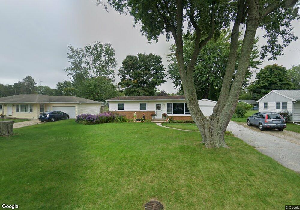
730 Sheridan Rd Saint Joseph, MI 49085
Vineland NeighborhoodEstimated Value: $227,000 - $278,000
3
Beds
1
Bath
1,390
Sq Ft
$174/Sq Ft
Est. Value
About This Home
This home is located at 730 Sheridan Rd, Saint Joseph, MI 49085 and is currently estimated at $241,461, approximately $173 per square foot. 730 Sheridan Rd is a home located in Berrien County with nearby schools including Upton Middle School, St. Joseph High School, and Brookview Montessori School.
Ownership History
Date
Name
Owned For
Owner Type
Purchase Details
Closed on
Jun 9, 2015
Sold by
Lenardson Jaimie Michael and Lenardson Denise M
Bought by
Lenardson Jaimie Michael and Lenardson Denise M
Current Estimated Value
Home Financials for this Owner
Home Financials are based on the most recent Mortgage that was taken out on this home.
Original Mortgage
$108,000
Outstanding Balance
$73,903
Interest Rate
0.78%
Mortgage Type
New Conventional
Estimated Equity
$167,558
Purchase Details
Closed on
Jun 21, 1993
Purchase Details
Closed on
Aug 31, 1992
Create a Home Valuation Report for This Property
The Home Valuation Report is an in-depth analysis detailing your home's value as well as a comparison with similar homes in the area
Home Values in the Area
Average Home Value in this Area
Purchase History
| Date | Buyer | Sale Price | Title Company |
|---|---|---|---|
| Lenardson Jaimie Michael | -- | Multiple | |
| -- | -- | -- | |
| -- | $64,000 | -- | |
| -- | $64,000 | -- |
Source: Public Records
Mortgage History
| Date | Status | Borrower | Loan Amount |
|---|---|---|---|
| Open | Lenardson Jaimie Michael | $108,000 |
Source: Public Records
Tax History Compared to Growth
Tax History
| Year | Tax Paid | Tax Assessment Tax Assessment Total Assessment is a certain percentage of the fair market value that is determined by local assessors to be the total taxable value of land and additions on the property. | Land | Improvement |
|---|---|---|---|---|
| 2025 | $2,199 | $86,000 | $0 | $0 |
| 2024 | $1,158 | $84,200 | $0 | $0 |
| 2023 | $1,103 | $84,600 | $0 | $0 |
| 2022 | $1,050 | $60,400 | $0 | $0 |
| 2021 | $1,965 | $57,800 | $15,100 | $42,700 |
| 2020 | $1,860 | $52,300 | $0 | $0 |
| 2019 | $1,799 | $51,100 | $11,000 | $40,100 |
| 2018 | $1,733 | $51,100 | $0 | $0 |
| 2017 | $1,713 | $50,200 | $0 | $0 |
| 2016 | $1,676 | $49,100 | $0 | $0 |
| 2015 | $1,650 | $46,700 | $0 | $0 |
| 2014 | $887 | $45,100 | $0 | $0 |
Source: Public Records
Map
Nearby Homes
- 649 Grant Ave
- 753 Lattimer Dr
- 3215 Meade Ct
- 2960 Niles Rd
- 2841 Niles Rd
- 670 Marvin Ave
- 398121 Anchors Way
- 530 Manitou Rd
- 985 Jean Ann Dr
- 940 Vineland Rd
- 1050 Jean Ann Dr
- 2865 Carrie Ln
- 2705 Oakwood Ln
- 792 Lonesome Pine Trail
- 2837 Washington Ave
- 2510 Bay Pointe Dr
- 2401 Bay Pointe Dr
- 2500 Bay Pointe Dr
- V/L Niles Rd
- 2317 S Pointe Way Unit 5