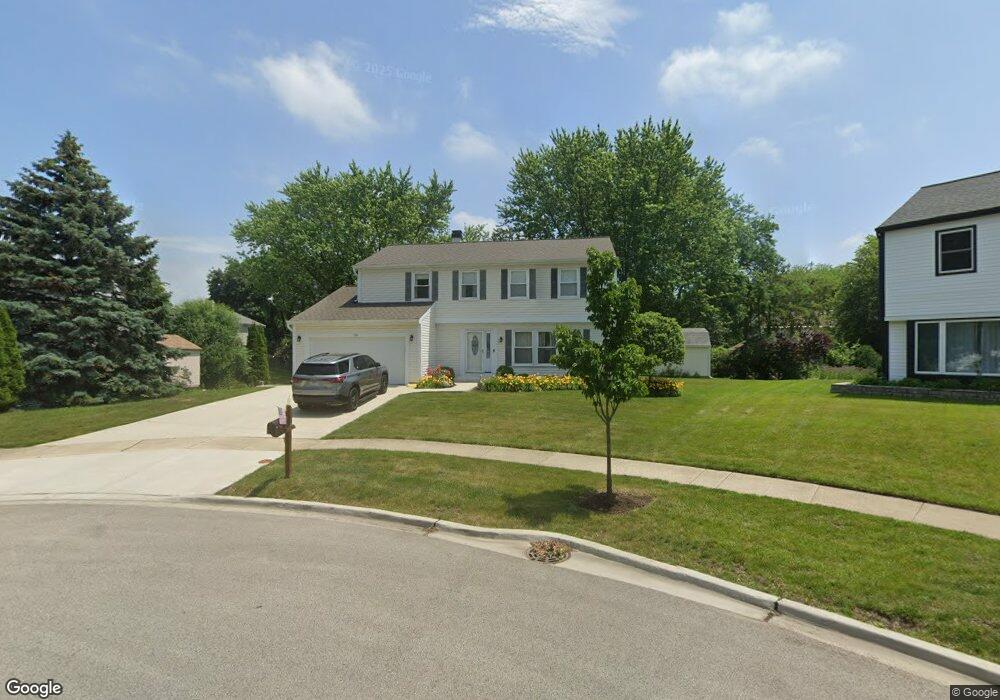
730 Thompson Blvd Buffalo Grove, IL 60089
Prairie Park-Lake County NeighborhoodEstimated Value: $579,680 - $615,000
--
Bed
3
Baths
2,103
Sq Ft
$283/Sq Ft
Est. Value
About This Home
This home is located at 730 Thompson Blvd, Buffalo Grove, IL 60089 and is currently estimated at $594,420, approximately $282 per square foot. 730 Thompson Blvd is a home located in Lake County with nearby schools including Prairie Elementary School, Twin Groves Middle School, and Adlai E Stevenson High School.
Ownership History
Date
Name
Owned For
Owner Type
Purchase Details
Closed on
Jan 14, 2008
Sold by
The Judith E Hackbart Trust
Bought by
Hackbart Judith E and Hackbart Rolland R
Current Estimated Value
Purchase Details
Closed on
Nov 9, 1999
Sold by
Hackbart Rolland R and Hackbart Judith E
Bought by
Hackbart Judith E and Judith E Hackbart Trust
Create a Home Valuation Report for This Property
The Home Valuation Report is an in-depth analysis detailing your home's value as well as a comparison with similar homes in the area
Home Values in the Area
Average Home Value in this Area
Purchase History
| Date | Buyer | Sale Price | Title Company |
|---|---|---|---|
| Hackbart Judith E | -- | None Available | |
| Hackbart Judith E | -- | -- |
Source: Public Records
Tax History Compared to Growth
Tax History
| Year | Tax Paid | Tax Assessment Tax Assessment Total Assessment is a certain percentage of the fair market value that is determined by local assessors to be the total taxable value of land and additions on the property. | Land | Improvement |
|---|---|---|---|---|
| 2024 | $14,002 | $169,703 | $42,523 | $127,180 |
| 2023 | $13,124 | $152,503 | $38,213 | $114,290 |
| 2022 | $13,124 | $136,857 | $34,293 | $102,564 |
| 2021 | $12,621 | $135,381 | $33,923 | $101,458 |
| 2020 | $12,325 | $135,843 | $34,039 | $101,804 |
| 2019 | $12,160 | $135,343 | $33,914 | $101,429 |
| 2018 | $11,432 | $131,752 | $33,518 | $98,234 |
| 2017 | $11,210 | $128,677 | $32,736 | $95,941 |
| 2016 | $10,896 | $123,218 | $31,347 | $91,871 |
| 2015 | $10,573 | $115,232 | $29,315 | $85,917 |
| 2014 | $9,946 | $107,629 | $31,484 | $76,145 |
| 2012 | $9,985 | $107,845 | $31,547 | $76,298 |
Source: Public Records
Map
Nearby Homes
- 1315 Gail Dr
- 531 Lasalle Ln
- 1327 Larchmont Dr
- 1027 Courtland Dr Unit 20
- 5135 Bridlewood Ct
- 5107 N Arlington Heights Rd
- 810 Silver Rock Ln
- 760 Checker Dr
- 12 Cloverdale Ct
- 938 Hidden Lake Dr
- 620 Twisted Oak Ln
- 1272 Sandhurst Dr
- 1325 Fairfax Ln
- 1117 Franklin Ln Unit C52
- 5255 Danbury Ct
- 630 Woodhollow Ln
- 131 Autumn Ct Unit CT10602
- 268 Hoffmann Dr
- 2015 Tree Farm Ct
- 4106 Bob o Link Ln
- 740 Thompson Ct
- 740 Thompson Blvd
- 1372 Brandywyn Ln
- 710 Thompson Blvd
- 1362 Brandywyn Ln
- 720 Thompson Blvd
- 700 Thompson Blvd
- 1352 Brandywyn Ln
- 750 Thompson Blvd
- 1342 Brandywyn Ln Unit 2
- 741 Chaucer Way
- 760 Thompson Blvd
- 770 Thompson Blvd
- 753 Chaucer Way Unit 2
- 729 Chaucer Way
- 765 Chaucer Way Unit 2
- 1371 Brandywyn Ln
- 1381 Brandywyn Ln
- 780 Thompson Blvd Unit 2
- 1361 Brandywyn Ln