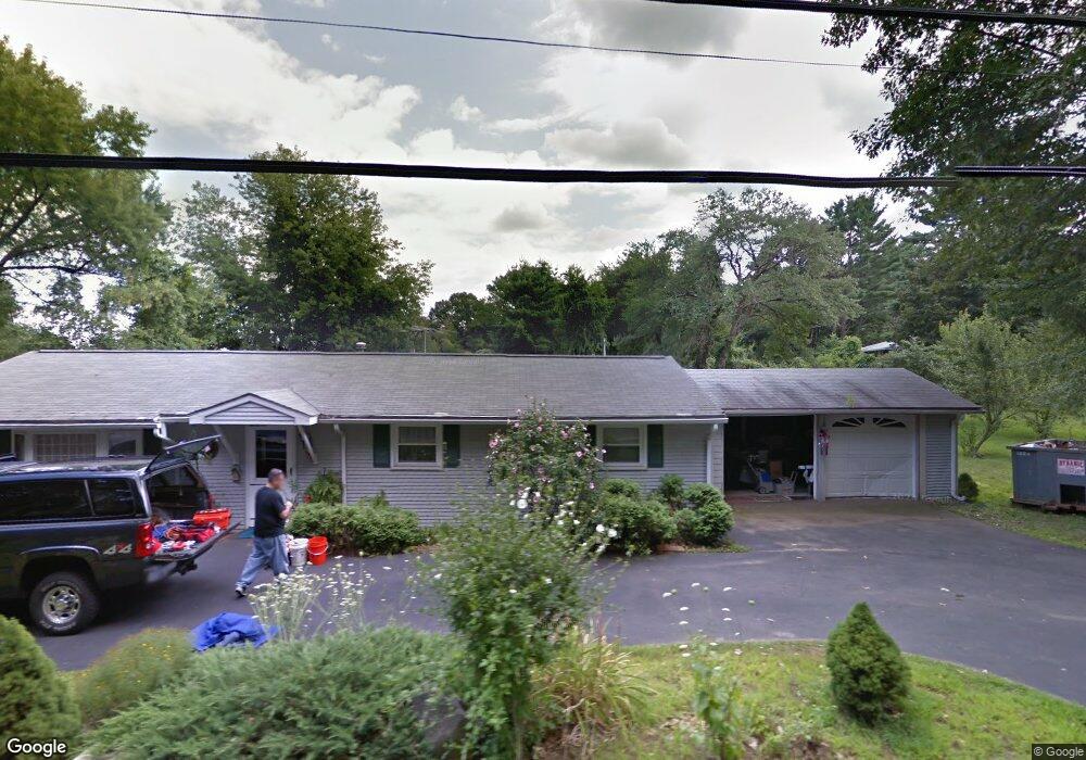
731 Concord Rd Marlborough, MA 01752
Estimated Value: $608,000 - $681,000
3
Beds
2
Baths
1,640
Sq Ft
$386/Sq Ft
Est. Value
About This Home
This home is located at 731 Concord Rd, Marlborough, MA 01752 and is currently estimated at $633,733, approximately $386 per square foot. 731 Concord Rd is a home located in Middlesex County with nearby schools including Marlborough High School, New Covenant Christian School, and Glenhaven Academy - JRI School.
Ownership History
Date
Name
Owned For
Owner Type
Purchase Details
Closed on
Jun 3, 2013
Sold by
Est Busceme Rose M and Mcdonald William C
Bought by
Vanaria Steven P and Mcdonald Rosemary A
Current Estimated Value
Home Financials for this Owner
Home Financials are based on the most recent Mortgage that was taken out on this home.
Original Mortgage
$160,000
Outstanding Balance
$111,297
Interest Rate
3%
Mortgage Type
Adjustable Rate Mortgage/ARM
Estimated Equity
$522,436
Purchase Details
Closed on
Jun 13, 2011
Sold by
Busceme Raymond S and Busceme Rose
Bought by
Busceme Rose
Home Financials for this Owner
Home Financials are based on the most recent Mortgage that was taken out on this home.
Original Mortgage
$75,000
Interest Rate
4.58%
Purchase Details
Closed on
Dec 17, 1998
Sold by
Jones Albert C and Jones Claire G
Bought by
Busceme Raymond S and Busceme Rose
Home Financials for this Owner
Home Financials are based on the most recent Mortgage that was taken out on this home.
Original Mortgage
$55,000
Interest Rate
6.85%
Mortgage Type
Purchase Money Mortgage
Purchase Details
Closed on
Mar 31, 1993
Sold by
Grady Richard and Grady Kathleen M
Bought by
Jones Albert C and Jones Claire G
Home Financials for this Owner
Home Financials are based on the most recent Mortgage that was taken out on this home.
Original Mortgage
$107,891
Interest Rate
7.6%
Mortgage Type
Purchase Money Mortgage
Create a Home Valuation Report for This Property
The Home Valuation Report is an in-depth analysis detailing your home's value as well as a comparison with similar homes in the area
Home Values in the Area
Average Home Value in this Area
Purchase History
| Date | Buyer | Sale Price | Title Company |
|---|---|---|---|
| Vanaria Steven P | $200,000 | -- | |
| Busceme Rose | -- | -- | |
| Busceme Raymond S | $157,000 | -- | |
| Jones Albert C | $116,500 | -- |
Source: Public Records
Mortgage History
| Date | Status | Borrower | Loan Amount |
|---|---|---|---|
| Open | Vanaria Steven P | $160,000 | |
| Previous Owner | Jones Albert C | $75,000 | |
| Previous Owner | Jones Albert C | $25,000 | |
| Previous Owner | Jones Albert C | $55,000 | |
| Previous Owner | Jones Albert C | $107,891 |
Source: Public Records
Tax History Compared to Growth
Tax History
| Year | Tax Paid | Tax Assessment Tax Assessment Total Assessment is a certain percentage of the fair market value that is determined by local assessors to be the total taxable value of land and additions on the property. | Land | Improvement |
|---|---|---|---|---|
| 2025 | $4,707 | $477,400 | $227,800 | $249,600 |
| 2024 | $4,733 | $462,200 | $207,100 | $255,100 |
| 2023 | $4,917 | $426,100 | $177,500 | $248,600 |
| 2022 | $4,819 | $367,300 | $169,000 | $198,300 |
| 2021 | $0 | $356,200 | $140,900 | $215,300 |
| 2020 | $4,871 | $343,500 | $134,200 | $209,300 |
| 2019 | $4,774 | $339,300 | $131,500 | $207,800 |
| 2018 | $7,855 | $301,800 | $112,600 | $189,200 |
| 2017 | $4,181 | $272,900 | $110,100 | $162,800 |
| 2016 | $4,059 | $264,600 | $110,100 | $154,500 |
| 2015 | $3,853 | $244,500 | $112,500 | $132,000 |
Source: Public Records
Map
Nearby Homes
- 17 Mcneil Cir
- 38 Collins Dr
- 492 Stow Rd
- 168 Blanchette Dr
- 274 Naugler Ave
- 618 Sudbury St
- 33A Russo Dr
- 551 Sudbury St
- 137 Naugler Ave
- 256 Robert Rd
- 114 Linda Cir
- 3 Stonehill Rd
- 323 Robert Rd
- 75 Kings View Rd
- 51 Murphy Rd
- 28 Stetson Dr
- 16 Minehan Ln
- 688 Boston Post Rd E Unit 202
- 688 Boston Post Rd E Unit 304
- 688 Boston Post Rd E Unit 100