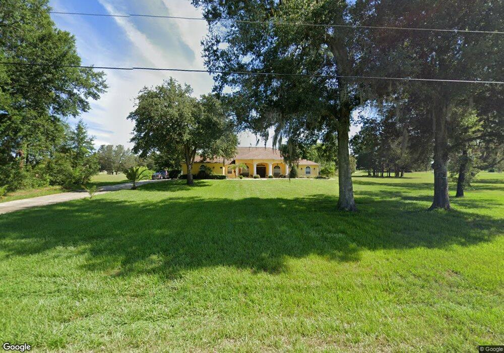
731 E Dunbar Ln Hernando, FL 34442
Estimated Value: $477,000 - $618,000
3
Beds
3
Baths
3,180
Sq Ft
$173/Sq Ft
Est. Value
About This Home
This home is located at 731 E Dunbar Ln, Hernando, FL 34442 and is currently estimated at $551,000, approximately $173 per square foot. 731 E Dunbar Ln is a home located in Citrus County with nearby schools including Forest Ridge Elementary School, Citrus Springs Middle School, and Lecanto High School.
Ownership History
Date
Name
Owned For
Owner Type
Purchase Details
Closed on
Apr 6, 2006
Sold by
Holladay Matthew and Holladay Trenita R
Bought by
Smith Page and Nazario Evelyn
Current Estimated Value
Purchase Details
Closed on
Dec 20, 2004
Sold by
Turcotte Serge Alain and Turcotte Patricia Louise
Bought by
Holladay Matthew and Holladay Trenita R
Purchase Details
Closed on
Feb 1, 1994
Bought by
Smith Page and Smith Evelyn Nazario
Create a Home Valuation Report for This Property
The Home Valuation Report is an in-depth analysis detailing your home's value as well as a comparison with similar homes in the area
Home Values in the Area
Average Home Value in this Area
Purchase History
| Date | Buyer | Sale Price | Title Company |
|---|---|---|---|
| Smith Page | $53,000 | Advantage Title & Trust Llc | |
| Holladay Matthew | $25,000 | Southern Security Title Serv | |
| Smith Page | $13,800 | -- |
Source: Public Records
Tax History
| Year | Tax Paid | Tax Assessment Tax Assessment Total Assessment is a certain percentage of the fair market value that is determined by local assessors to be the total taxable value of land and additions on the property. | Land | Improvement |
|---|---|---|---|---|
| 2025 | $6,945 | $465,424 | $32,000 | $433,424 |
| 2024 | $6,590 | $492,755 | $26,500 | $466,255 |
| 2023 | $6,590 | $483,966 | $24,000 | $459,966 |
| 2022 | $5,600 | $400,008 | $18,000 | $382,008 |
| 2021 | $4,844 | $325,165 | $12,880 | $312,285 |
| 2020 | $4,413 | $296,508 | $11,400 | $285,108 |
| 2019 | $4,147 | $274,237 | $10,000 | $264,237 |
| 2018 | $3,912 | $258,944 | $8,660 | $250,284 |
| 2017 | $3,594 | $227,880 | $11,000 | $216,880 |
| 2016 | $3,744 | $233,554 | $10,500 | $223,054 |
| 2015 | $3,436 | $204,367 | $9,780 | $194,587 |
| 2014 | $3,487 | $206,240 | $10,098 | $196,142 |
Source: Public Records
Map
Nearby Homes
- 701 E Connecticut Ln
- 574 E Everett Ln
- 3034 N Clements Ave
- 3002 N Clements Ave
- 3292 N Annapolis Ave
- 570 E Bismark St
- 3366 N Annapolis Ave
- 1060 E Rockefeller Ln
- 3076 N Clements Ave
- 826 E Gaines Ln
- 1139 E Mckinley St
- 656 E Alaska Ln
- 105 E Samuel Ct
- 2988 N Anthony Ave
- 2924 N Anthony Ave
- 1255 E Rockefeller Ln
- 1012 & 1030 E Mckinley St
- 1716 E Bismark St
- 1011 E Bismark St
- 1401 E Bismark St
- 703 E Dunbar Ln
- 757 E Dunbar Ln
- 732 E Everett Ln
- 789 E Dunbar Ln
- 704 E Everett Ln
- 596 E Dunbar Ln
- 0 E Dunbar Ln
- 684 E Dunbar Ln
- 702 E Dunbar Ln
- 574 E Dunbar Ln
- 790 E Everett Ln
- 649 E Dunbar Ln
- 803 E Dunbar Ln
- 800 E Dunbar Ln
- 650 E Everett Ln
- 676 E Everett Ln
- 0 E Everett Ln
- 628 E Everett Ln
- 660 E Dunbar Ln
Your Personal Tour Guide
Ask me questions while you tour the home.