
Seller's Agent in 2026
Michael Lohens
RE/MAX
(847) 921-5522
2 in this area
127 Total Sales

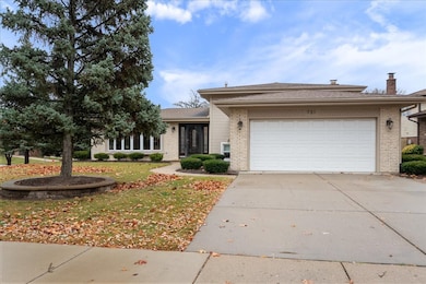
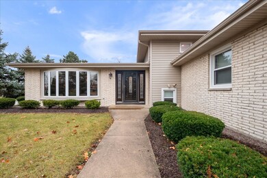
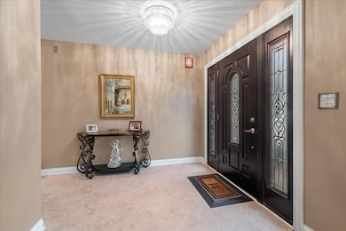
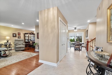
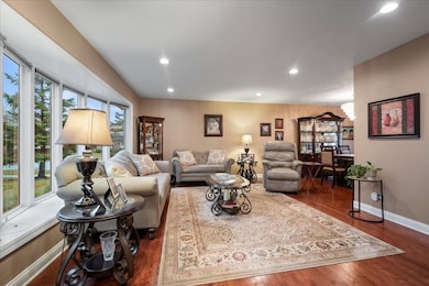
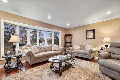
Beautiful bi level home in highly desirable Lancer Park offering 3 bedrooms and 3 full baths on a large corner lot measuring 10450 square feet with a fully fenced backyard and paver brick patio. This impeccably maintained home features a six year old kitchen with wood cabinets, granite countertops and stainless steel appliances, a formal living room with a large bow window, hardwood floors and recessed lighting, and a lower level family room with ceramic tile flooring, a wood burning fireplace and a full bath with shower. The large laundry room provides access to the heated attached garage. The second floor includes three bedrooms and two updated full bathrooms, all with hardwood floors and generous closets, and the primary bedroom offers a full bath with a stunning walk in shower. Additional updates include HVAC and water tank replaced in 2016 along with newer windows, many with plantation shutters. Great location close to shopping, restaurants and parks. Basement refrigerator and stove stay with the property. Seller prefers an end of January closing.
Last Agent to Sell the Property
RE/MAX Properties Northwest Brokerage Phone: (847) 921-5522 License #475139093 Listed on: 11/19/2025
| Date | Type | Sale Price | Title Company |
|---|---|---|---|
| Warranty Deed | $575,000 | Chicago Title | |
| Warranty Deed | -- | None Listed On Document | |
| Deed | -- | None Listed On Document | |
| Interfamily Deed Transfer | -- | None Available | |
| Interfamily Deed Transfer | -- | None Available | |
| Warranty Deed | $219,000 | -- |
| Date | Status | Loan Amount | Loan Type |
|---|---|---|---|
| Open | $517,500 | New Conventional |
| Date | Event | Price | List to Sale | Price per Sq Ft |
|---|---|---|---|---|
| 01/29/2026 01/29/26 | Sold | $575,000 | +4.6% | $279 / Sq Ft |
| 11/26/2025 11/26/25 | Pending | -- | -- | -- |
| 11/19/2025 11/19/25 | For Sale | $549,900 | -- | $267 / Sq Ft |
| Year | Tax Paid | Tax Assessment Tax Assessment Total Assessment is a certain percentage of the fair market value that is determined by local assessors to be the total taxable value of land and additions on the property. | Land | Improvement |
|---|---|---|---|---|
| 2025 | $9,067 | $46,001 | $10,973 | $35,028 |
| 2024 | $9,067 | $39,000 | $9,405 | $29,595 |
| 2023 | $5,432 | $39,000 | $9,405 | $29,595 |
| 2022 | $5,432 | $39,000 | $9,405 | $29,595 |
| 2021 | $5,902 | $29,597 | $7,053 | $22,544 |
| 2020 | $5,588 | $29,597 | $7,053 | $22,544 |
| 2019 | $5,374 | $32,886 | $7,053 | $25,833 |
| 2018 | $6,028 | $32,532 | $6,008 | $26,524 |
| 2017 | $5,829 | $33,256 | $6,008 | $27,248 |
| 2016 | $8,004 | $33,256 | $6,008 | $27,248 |
| 2015 | $7,473 | $29,476 | $5,225 | $24,251 |
| 2014 | $8,722 | $29,476 | $5,225 | $24,251 |
| 2013 | $7,198 | $29,476 | $5,225 | $24,251 |
Seller's Agent in 2026
Michael Lohens
RE/MAX
(847) 921-5522
2 in this area
127 Total Sales
Buyer's Agent in 2026
Mariana Ivantsiv
KOMAR
(773) 801-6230
4 in this area
56 Total Sales
Source: Midwest Real Estate Data (MRED)
MLS Number: 12520662
APN: 07-26-117-007-0000
Disclaimer: Certain information contained herein is derived from information provided by parties other than Homes.com. All information provided is deemed reliable, but is not guaranteed to be accurate and should be independently verified.
![]() Based on information submitted to the MLS GRID. All data is obtained from various sources and may not have been verified by broker or MLS GRID. Supplied Open House Information is subject to change without notice. All information should be independently reviewed and verified for accuracy. Properties may or may not be listed by the office/agent presenting the information. Some IDX listings have been excluded from this website.
Based on information submitted to the MLS GRID. All data is obtained from various sources and may not have been verified by broker or MLS GRID. Supplied Open House Information is subject to change without notice. All information should be independently reviewed and verified for accuracy. Properties may or may not be listed by the office/agent presenting the information. Some IDX listings have been excluded from this website.
Based on information submitted to the MLS GRID
Ask me questions while you tour the home.