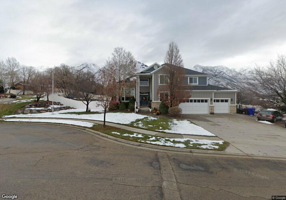
731 S Blue Ridge Cir Alpine, UT 84004
Estimated Value: $1,105,000 - $1,379,000
5
Beds
3
Baths
4,596
Sq Ft
$267/Sq Ft
Est. Value
About This Home
This home is located at 731 S Blue Ridge Cir, Alpine, UT 84004 and is currently estimated at $1,226,947, approximately $266 per square foot. 731 S Blue Ridge Cir is a home located in Utah County with nearby schools including Westfield School, Timberline Middle School, and Lone Peak High School.
Ownership History
Date
Name
Owned For
Owner Type
Purchase Details
Closed on
Feb 5, 2015
Sold by
Coverston S Jason
Bought by
The Coverston Family Revocable Trust and Coverston Gaylee Page
Current Estimated Value
Home Financials for this Owner
Home Financials are based on the most recent Mortgage that was taken out on this home.
Original Mortgage
$417,000
Outstanding Balance
$319,391
Interest Rate
3.76%
Mortgage Type
New Conventional
Estimated Equity
$907,556
Purchase Details
Closed on
Feb 15, 2011
Sold by
Coverston Jason
Bought by
Coverston Sam Jason and Coverston Gaylee Page
Home Financials for this Owner
Home Financials are based on the most recent Mortgage that was taken out on this home.
Original Mortgage
$345,300
Interest Rate
4.67%
Mortgage Type
New Conventional
Purchase Details
Closed on
Jun 24, 2010
Sold by
Coverston S Jason and Coverston Gaylee Page
Bought by
Coverston Sam Jason and Coverston Gaylee Page
Purchase Details
Closed on
Feb 8, 2008
Sold by
Coverston S Jason
Bought by
Coverston S Jason and Coverston Gaylee Page
Home Financials for this Owner
Home Financials are based on the most recent Mortgage that was taken out on this home.
Original Mortgage
$65,473
Interest Rate
5.85%
Mortgage Type
Stand Alone Second
Purchase Details
Closed on
Jul 19, 2006
Sold by
Raban Scott and Raban Roberta
Bought by
Tyler Gary D
Home Financials for this Owner
Home Financials are based on the most recent Mortgage that was taken out on this home.
Original Mortgage
$115,100
Interest Rate
6.69%
Mortgage Type
Stand Alone Second
Purchase Details
Closed on
Jul 27, 1999
Sold by
Davis Stephanie
Bought by
Raban Scott and Raban Roberta
Home Financials for this Owner
Home Financials are based on the most recent Mortgage that was taken out on this home.
Original Mortgage
$292,500
Interest Rate
7.64%
Purchase Details
Closed on
Sep 24, 1998
Sold by
Park At South Pointe L C
Bought by
Davis Stephanie
Create a Home Valuation Report for This Property
The Home Valuation Report is an in-depth analysis detailing your home's value as well as a comparison with similar homes in the area
Home Values in the Area
Average Home Value in this Area
Purchase History
| Date | Buyer | Sale Price | Title Company |
|---|---|---|---|
| The Coverston Family Revocable Trust | -- | Sutherland Title Co | |
| Coverston S Jason | -- | Sutherland Title Co | |
| Coverston Sam Jason | -- | Inwest Title Services Inc | |
| Coverston Jason | -- | Inwest Title Services Inc | |
| Coverston Sam Jason | -- | None Available | |
| Coverston S Jason | -- | Accommodation | |
| Coverston S Jason | -- | Highland Title | |
| Tyler Gary D | -- | None Available | |
| Raban Scott | -- | First American Title Ins Co | |
| Davis Stephanie | -- | Signature Title |
Source: Public Records
Mortgage History
| Date | Status | Borrower | Loan Amount |
|---|---|---|---|
| Open | Coverston S Jason | $417,000 | |
| Closed | Coverston Jason | $345,300 | |
| Closed | Coverston S Jason | $65,473 | |
| Closed | Coverston S Jason | $349,192 | |
| Previous Owner | Tyler Gary D | $115,100 | |
| Previous Owner | Raban Scott | $292,500 |
Source: Public Records
Tax History
| Year | Tax Paid | Tax Assessment Tax Assessment Total Assessment is a certain percentage of the fair market value that is determined by local assessors to be the total taxable value of land and additions on the property. | Land | Improvement |
|---|---|---|---|---|
| 2025 | $4,427 | $555,170 | -- | -- |
| 2024 | $4,427 | $516,010 | $0 | $0 |
| 2023 | $4,207 | $526,350 | $0 | $0 |
| 2022 | $4,456 | $541,475 | $0 | $0 |
| 2021 | $4,025 | $759,800 | $274,700 | $485,100 |
| 2020 | $3,926 | $725,300 | $249,700 | $475,600 |
| 2019 | $3,350 | $646,000 | $249,700 | $396,300 |
| 2018 | $2,974 | $566,600 | $222,000 | $344,600 |
| 2017 | $3,073 | $311,630 | $0 | $0 |
| 2016 | $3,066 | $289,850 | $0 | $0 |
| 2015 | $3,022 | $270,215 | $0 | $0 |
| 2014 | $2,931 | $259,325 | $0 | $0 |
Source: Public Records
Map
Nearby Homes
- 596 S Cascade Ct
- 690 S High Ridge Dr
- 5046 W Jonathon Rd Unit 10
- 868 S Braddock Ln
- 243 W Conrad Ct
- 682 Healey Blvd
- 250 S Main St Unit 25
- 250 S Main St Unit 24
- 250 S Main St Unit 9
- 250 S Main St Unit 7
- 259 Twin River Loop
- 11107 Manor Dr Unit 1
- 366 River Rd
- 5246 W 11200 N Unit 1
- 5984 W 11200 N Unit 1
- 30 S Main St
- 202 E Alpine Dr
- 802 S East Mountain Cir
- 5238 W 11100 St N Unit 2
- 48 N 100 E
- 731 Blue Ridge Cir
- 763 S Blue Ridge Cir
- 763 Blue Ridge Cir
- 873 S Canyon Crest Rd
- 719 Blue Ridge Cir
- 736 Blue Ridge Cir
- 772 Blue Ridge Cir
- 720 Blue Ridge Cir
- 779 Blue Ridge Cir
- 735 S Canyon Crest Rd
- 799 S Blue Ridge Cir
- 775 S Canyon Crest Rd
- 278 Carlisle Ave
- 798 S Blue Ridge Ln
- 147 Sunset Cir
- 314 Carlisle Ave
- 236 E Pyrenees Dr
- 809 Blue Ridge Ln
- 812 Blue Ridge Ln
- 700 S Blue Ridge Ln Unit 712
Your Personal Tour Guide
Ask me questions while you tour the home.