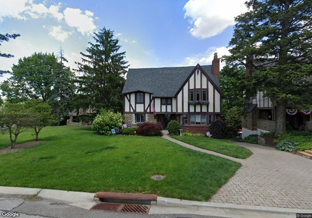
732 Glenshire Ave Cincinnati, OH 45226
Mount Lookout NeighborhoodEstimated Value: $751,278 - $982,000
4
Beds
4
Baths
2,713
Sq Ft
$313/Sq Ft
Est. Value
About This Home
This home is located at 732 Glenshire Ave, Cincinnati, OH 45226 and is currently estimated at $848,320, approximately $312 per square foot. 732 Glenshire Ave is a home located in Hamilton County with nearby schools including Kilgour Elementary School, Clark Montessori High School, and Shroder High School.
Ownership History
Date
Name
Owned For
Owner Type
Purchase Details
Closed on
Dec 21, 2007
Sold by
Arken Andrew Howard and Arken Renee Rivard
Bought by
Taschuk David G and Taschuk Beth A
Current Estimated Value
Home Financials for this Owner
Home Financials are based on the most recent Mortgage that was taken out on this home.
Original Mortgage
$376,000
Interest Rate
6.27%
Mortgage Type
Unknown
Create a Home Valuation Report for This Property
The Home Valuation Report is an in-depth analysis detailing your home's value as well as a comparison with similar homes in the area
Home Values in the Area
Average Home Value in this Area
Purchase History
We collect this data history from publicly available records. To have your information removed, we recommend requesting removal directly through your county’s website.
| Date | Buyer | Sale Price | Title Company |
|---|---|---|---|
| Taschuk David G | -- | Ltoc |
Source: Public Records
Mortgage History
We collect this data history from publicly available records. To have your information removed, we recommend requesting removal directly through your county’s website.
| Date | Status | Borrower | Loan Amount |
|---|---|---|---|
| Closed | Taschuk David G | $376,000 |
Source: Public Records
Tax History
| Year | Tax Paid | Tax Assessment Tax Assessment Total Assessment is a certain percentage of the fair market value that is determined by local assessors to be the total taxable value of land and additions on the property. | Land | Improvement |
|---|---|---|---|---|
| 2025 | $11,803 | $191,716 | $50,722 | $140,994 |
| 2024 | $11,445 | $191,716 | $50,722 | $140,994 |
| 2023 | $11,703 | $191,716 | $50,722 | $140,994 |
| 2022 | $12,094 | $177,727 | $48,108 | $129,619 |
| 2021 | $11,642 | $177,727 | $48,108 | $129,619 |
| 2020 | $11,983 | $177,727 | $48,108 | $129,619 |
| 2019 | $11,194 | $151,904 | $41,118 | $110,786 |
| 2018 | $11,212 | $151,904 | $41,118 | $110,786 |
| 2017 | $10,651 | $151,904 | $41,118 | $110,786 |
| 2016 | $10,138 | $142,577 | $37,825 | $104,752 |
| 2015 | $9,140 | $142,577 | $37,825 | $104,752 |
| 2014 | $9,205 | $142,577 | $37,825 | $104,752 |
| 2013 | $8,836 | $134,506 | $35,683 | $98,823 |
Source: Public Records
Map
Nearby Homes
- 878 Tweed Ave
- 3255 Linwood Ave
- 909 Ellison Ave
- 3245 Nash Ave
- 1080 Tuscany Place
- 1337 Herlin Place
- 3559 Kroger Ave
- 3550 Linwood Ave
- 3200 Grischy Ln
- 681 Totten Way
- 658 Rushton Rd
- 3527 Kroger Ave
- 3518 Kroger Ave
- 764 Delta Ave
- 4612 Eastern Ave
- 3065 Alpine Terrace
- 4816 Eastern Ave
- 621 Athens Ave
- 1211 Herschel Woods Ln
- 3219 Hardisty Ave
- 728 Glenshire Ave
- 740 Tweed Ave
- 724 Glenshire Ave
- 749 Mannington Ave
- 743 Mannington Ave
- 795 Mannington Ave
- 720 Glenshire Ave
- 737 Mannington Ave
- 706 Tweed Ave
- 801 Mannington Ave
- 729 Mannington Ave
- 737 Tweed Ave
- 741 Tweed Ave
- 747 Tweed Ave
- 712 Glenshire Ave
- 794 Mannington Ave
- 792 Mannington Ave
- 738 Mannington Ave
- 744 Mannington Ave
- 719 Mannington Ave
Your Personal Tour Guide
Ask me questions while you tour the home.