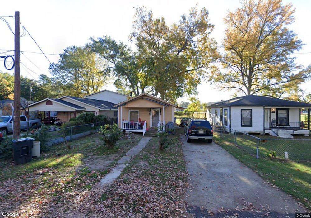
732 Rentur St Shreveport, LA 71106
East Shreveport NeighborhoodEstimated Value: $28,000 - $46,000
3
Beds
1
Bath
806
Sq Ft
$48/Sq Ft
Est. Value
About This Home
This home is located at 732 Rentur St, Shreveport, LA 71106 and is currently estimated at $38,776, approximately $48 per square foot. 732 Rentur St is a home with nearby schools including Fairfield Magnet School, Judson Fundamental Elementary School, and Eden Gardens Fundamental Elementary School.
Ownership History
Date
Name
Owned For
Owner Type
Purchase Details
Closed on
Jun 21, 2013
Sold by
Stewart Mary and Tylor Helen
Bought by
Orion 2013 Llc
Current Estimated Value
Purchase Details
Closed on
Mar 18, 2011
Sold by
Holdingsllc Pintail
Bought by
Taylor Mary Helen
Purchase Details
Closed on
Feb 14, 2011
Sold by
High Sierra Tax Sale Properties Llc
Bought by
Pintail Holdings Llc
Purchase Details
Closed on
Jun 14, 2007
Sold by
Stewart Mary Helen Taylor
Bought by
Jemico Llc
Purchase Details
Closed on
Jun 8, 2007
Sold by
Stewart Mary Helen Taylor
Bought by
High Sierra Tax Sale Properties Llc
Create a Home Valuation Report for This Property
The Home Valuation Report is an in-depth analysis detailing your home's value as well as a comparison with similar homes in the area
Home Values in the Area
Average Home Value in this Area
Purchase History
| Date | Buyer | Sale Price | Title Company |
|---|---|---|---|
| Orion 2013 Llc | $277 | None Available | |
| Taylor Mary Helen | -- | None Available | |
| Pintail Holdings Llc | -- | None Available | |
| Jemico Llc | $159 | None Available | |
| High Sierra Tax Sale Properties Llc | $444 | None Available |
Source: Public Records
Tax History Compared to Growth
Tax History
| Year | Tax Paid | Tax Assessment Tax Assessment Total Assessment is a certain percentage of the fair market value that is determined by local assessors to be the total taxable value of land and additions on the property. | Land | Improvement |
|---|---|---|---|---|
| 2024 | $391 | $2,510 | $399 | $2,111 |
| 2023 | $397 | $2,491 | $380 | $2,111 |
| 2022 | $397 | $2,491 | $380 | $2,111 |
| 2021 | $391 | $2,491 | $380 | $2,111 |
| 2020 | $391 | $2,491 | $380 | $2,111 |
| 2019 | $360 | $2,229 | $380 | $1,849 |
| 2018 | $0 | $2,491 | $380 | $2,111 |
| 2017 | $409 | $2,491 | $380 | $2,111 |
| 2015 | -- | $2,750 | $380 | $2,370 |
| 2014 | $359 | $2,750 | $380 | $2,370 |
| 2013 | -- | $2,750 | $380 | $2,370 |
Source: Public Records
Map
Nearby Homes
- 7526 Harris St
- 567 E 73rd St
- 685 Bernard Blvd
- 0 Palestine St Unit 20985909
- 7713 Gideon St
- 636 E 70th St
- 7070 Creswell Rd
- 7116 Creswell Rd
- 7040 Creswell Rd
- 530 Spring Lake Dr
- 569 Spring Lake Dr
- 565 Spring Lake Dr
- 7000 Creswell Rd Unit 223
- 218 Beechcraft Way
- 6835 Bethany St
- 72 Spring Lake Way
- 589 Spring Lake Dr
- 638 Ashbourne Dr
- 7211 Gilbert Dr
- 618 Balmoral Dr
- 730 Rentur St
- 722 Rentur St
- 734 Rentur St
- 719 Rentur St
- 7507 Liberty St
- 7511 Liberty St
- 7503 Liberty St
- 7515 Liberty St
- 7519 Liberty St
- 7523 Liberty St
- 7531 Liberty St
- 710 Turner Ln
- 7505 Harris St
- 7509 Harris St
- 7537 Liberty St
- 7518 Harris St
- 7514 Harris St
- 7522 Harris St
- 7534 Harris St
- 730 Turner Ln