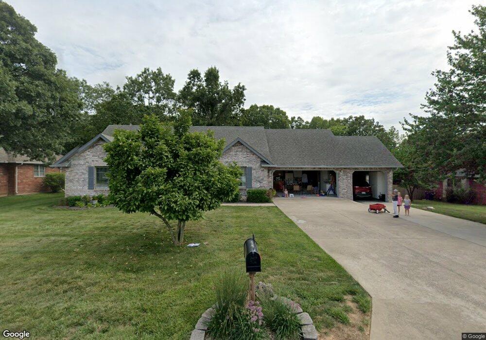
732 Rosewood Dr Lebanon, MO 65536
Estimated Value: $244,000 - $330,000
--
Bed
--
Bath
2,138
Sq Ft
$127/Sq Ft
Est. Value
About This Home
This home is located at 732 Rosewood Dr, Lebanon, MO 65536 and is currently estimated at $271,927, approximately $127 per square foot. 732 Rosewood Dr is a home located in Laclede County with nearby schools including Joe D. Esther Elementary School, Boswell Elementary School, and Maplecrest Elementary School.
Ownership History
Date
Name
Owned For
Owner Type
Purchase Details
Closed on
Aug 19, 2011
Sold by
Knight Gerald C and Knight Wanda L
Bought by
Knight Gerald C and Knight Wanda L
Current Estimated Value
Home Financials for this Owner
Home Financials are based on the most recent Mortgage that was taken out on this home.
Original Mortgage
$119,000
Interest Rate
4.54%
Mortgage Type
New Conventional
Purchase Details
Closed on
Apr 7, 2011
Sold by
Knight Gerald and Knight Wanda
Bought by
Knight Gerald C and Knight Wanda L
Create a Home Valuation Report for This Property
The Home Valuation Report is an in-depth analysis detailing your home's value as well as a comparison with similar homes in the area
Home Values in the Area
Average Home Value in this Area
Purchase History
| Date | Buyer | Sale Price | Title Company |
|---|---|---|---|
| Knight Gerald C | -- | None Available | |
| Knight Gerald C | -- | None Available | |
| Knight Gerald C | -- | None Available |
Source: Public Records
Mortgage History
| Date | Status | Borrower | Loan Amount |
|---|---|---|---|
| Closed | Knight Gerald C | $119,000 |
Source: Public Records
Tax History Compared to Growth
Tax History
| Year | Tax Paid | Tax Assessment Tax Assessment Total Assessment is a certain percentage of the fair market value that is determined by local assessors to be the total taxable value of land and additions on the property. | Land | Improvement |
|---|---|---|---|---|
| 2025 | $1,157 | $23,120 | $0 | $0 |
| 2024 | $1,157 | $20,390 | $0 | $0 |
| 2023 | $1,198 | $20,390 | $0 | $0 |
| 2022 | $1,116 | $20,390 | $0 | $0 |
| 2021 | $1,229 | $20,387 | $2,166 | $18,221 |
| 2020 | $1,235 | $20,387 | $2,166 | $18,221 |
| 2019 | $1,183 | $20,390 | $2,170 | $18,220 |
| 2018 | $1,111 | $20,390 | $2,170 | $18,220 |
| 2017 | $1,053 | $20,390 | $0 | $0 |
| 2016 | $1,053 | $20,390 | $0 | $0 |
| 2015 | $1,053 | $20,390 | $0 | $0 |
| 2014 | $1,053 | $20,390 | $0 | $0 |
| 2013 | -- | $20,390 | $0 | $0 |
Source: Public Records
Map
Nearby Homes
- TBD Honeysuckle Cir
- 1520 Fairfield Dr
- 708 Herndon Rd
- 1040 Daytona Dr
- 25611 Open Ridge Ln
- 605 Hunters Creek Dr
- 600 Hunters Creek Dr
- 000 Gateway Rd
- 18826 Highway 64
- 000 Greenfield Rd
- TBD Greenfield Rd
- 100 S Bend Rd
- 376 Sunset Dr
- 1491 Brice St
- 750 Lynn St
- 1075 Lynn St
- 231 Raef Rd
- 1540 Woodhill Dr
- 1250 N Jefferson Ave
- 175 Walser St
- 740 Rosewood Dr
- 724 Rosewood Dr
- 1712 Bittersweet Ln
- 716 Rosewood Dr
- 748 Rosewood Dr
- 1713 Bittersweet Cir
- 1713 Bittersweet Ln
- 717 Rosewood Dr
- 708 Rosewood Dr
- 1722 Bittersweet Cir
- 1722 Bittersweet Ln
- 819 Rosewood Dr
- 1723 Bittersweet Ln
- 1723 Honeysuckle Cir
- 700 Rosewood Dr
- 825 Rosewood Dr
- 215 Rosewood Dr
- 1712 Honeysuckle Cir
- 821 Freddie Ln
- 806 Rosewood Dr