Estimated Value: $493,000 - $552,000
5
Beds
3
Baths
1,992
Sq Ft
$267/Sq Ft
Est. Value
About This Home
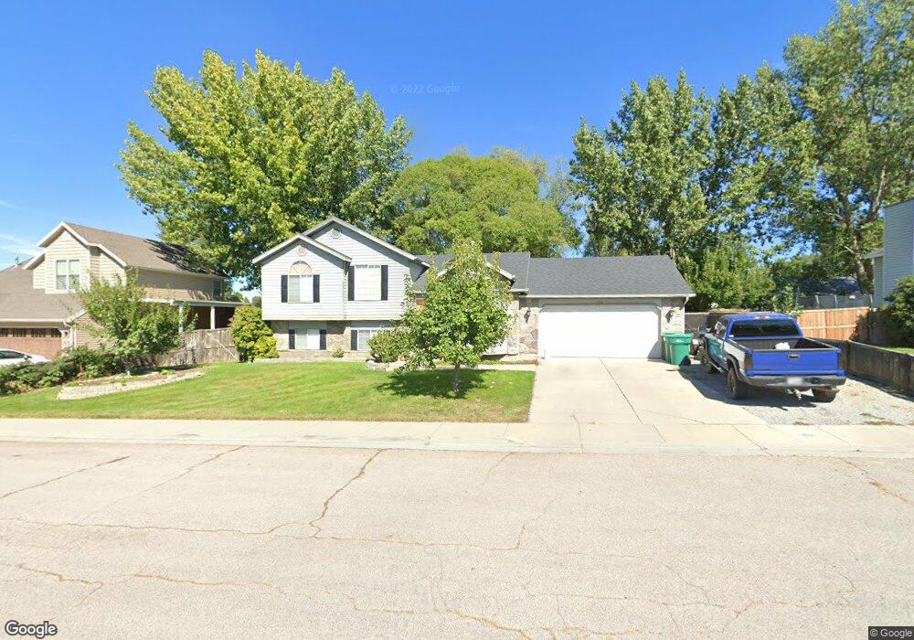
This home is located at 732 W 2140 N, Lehi, UT 84043 and is currently estimated at $530,954, approximately $266 per square foot. 732 W 2140 N is a home located in Utah County with nearby schools including Fox Hollow Elementary School and Skyridge High School.
Ownership History
Date
Name
Owned For
Owner Type
Purchase Details
Closed on
Jun 21, 2023
Sold by
Family Trust Of John A Baxter And Ione W and Baxter Ione W
Bought by
Mills John Joseph and Mills Brittany Ann
Current Estimated Value
Home Financials for this Owner
Home Financials are based on the most recent Mortgage that was taken out on this home.
Original Mortgage
$513,000
Outstanding Balance
$499,182
Interest Rate
6.35%
Mortgage Type
New Conventional
Estimated Equity
$31,772
Purchase Details
Closed on
Jun 20, 2023
Sold by
John A Baxter And Ione W Baxter Trust
Bought by
Amended And Restated Family Trust
Home Financials for this Owner
Home Financials are based on the most recent Mortgage that was taken out on this home.
Original Mortgage
$513,000
Outstanding Balance
$499,182
Interest Rate
6.35%
Mortgage Type
New Conventional
Estimated Equity
$31,772
Purchase Details
Closed on
Apr 17, 2008
Sold by
Floyd Kevin D and Floyd Heather L
Bought by
Baxter John A and Baxter Ione W
Purchase Details
Closed on
Mar 24, 2006
Sold by
Lynn Ronald D
Bought by
Floyd Kevin D and Floyd Heather L
Home Financials for this Owner
Home Financials are based on the most recent Mortgage that was taken out on this home.
Original Mortgage
$183,111
Interest Rate
6.25%
Mortgage Type
VA
Purchase Details
Closed on
Oct 3, 2002
Sold by
Fannie Mae
Bought by
Lynn Ronald D
Home Financials for this Owner
Home Financials are based on the most recent Mortgage that was taken out on this home.
Original Mortgage
$111,000
Interest Rate
6.22%
Mortgage Type
Purchase Money Mortgage
Purchase Details
Closed on
Jul 23, 2002
Sold by
North American Mtg Company
Bought by
Federal National Mortgage Association
Purchase Details
Closed on
Jul 12, 2002
Sold by
Caussey Danny D and Caussey Jennifer R
Bought by
North American Mtg Company
Purchase Details
Closed on
Apr 25, 1997
Sold by
Caussey Danny D
Bought by
Caussey Danny D and Caussey Jennifer R
Home Financials for this Owner
Home Financials are based on the most recent Mortgage that was taken out on this home.
Original Mortgage
$108,000
Interest Rate
7.96%
Create a Home Valuation Report for This Property
The Home Valuation Report is an in-depth analysis detailing your home's value as well as a comparison with similar homes in the area
Home Values in the Area
Average Home Value in this Area
Purchase History
| Date | Buyer | Sale Price | Title Company |
|---|---|---|---|
| Mills John Joseph | -- | Utah First Title | |
| Amended And Restated Family Trust | -- | Utah First Title | |
| Baxter John A | -- | Equity Title Orem Blvd | |
| Floyd Kevin D | -- | Quality Title | |
| Lynn Ronald D | $139,000 | Empire Land Title Company | |
| Federal National Mortgage Association | -- | First Southwestern Title | |
| North American Mtg Company | -- | First Southwestern Title | |
| Caussey Danny D | -- | Inwest Title Services Inc |
Source: Public Records
Mortgage History
| Date | Status | Borrower | Loan Amount |
|---|---|---|---|
| Open | Mills John Joseph | $513,000 | |
| Previous Owner | Floyd Kevin D | $183,111 | |
| Previous Owner | Lynn Ronald D | $111,000 | |
| Previous Owner | Caussey Danny D | $108,000 | |
| Closed | Lynn Ronald D | $9,000 |
Source: Public Records
Tax History Compared to Growth
Tax History
| Year | Tax Paid | Tax Assessment Tax Assessment Total Assessment is a certain percentage of the fair market value that is determined by local assessors to be the total taxable value of land and additions on the property. | Land | Improvement |
|---|---|---|---|---|
| 2025 | $2,075 | $276,485 | $193,900 | $308,800 |
| 2024 | $2,075 | $242,880 | $0 | $0 |
| 2023 | $1,915 | $243,320 | $0 | $0 |
| 2022 | $2,063 | $254,155 | $0 | $0 |
| 2021 | $1,839 | $342,500 | $112,200 | $230,300 |
| 2020 | $1,733 | $319,100 | $103,900 | $215,200 |
| 2019 | $1,538 | $294,300 | $103,900 | $190,400 |
| 2018 | $1,499 | $271,200 | $94,700 | $176,500 |
| 2017 | $1,339 | $128,755 | $0 | $0 |
| 2016 | $1,322 | $117,975 | $0 | $0 |
| 2015 | $1,298 | $109,945 | $0 | $0 |
| 2014 | $1,247 | $104,995 | $0 | $0 |
Source: Public Records
Map
Nearby Homes
- 2287 N 750 W
- 497 W 2200 N
- 516 W 2280 N
- 1011 W Mountain Way Unit 316
- 424 W 1700 N
- 1272 W 1800 N
- 1610 N 1125 W
- 1249 W 1800 N
- 902 W 1500 N
- 2600 N 1200 W Unit 6
- 2908 N 1080 W
- 1332 W 1500 N
- 1301 N 900 W Unit 12
- 51 N Carter Dr
- 5344 N Trail Side Ct
- 1155 W 2980 N
- 1167 W 2980 N
- 1179 W 2980 N
- 192 E 2200 N
- 1882 N 2230 St W Unit 24