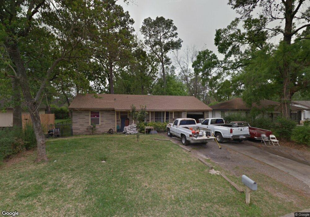
7330 Caddo Rd Houston, TX 77016
East Little York NeighborhoodEstimated Value: $134,646 - $176,000
3
Beds
1
Bath
887
Sq Ft
$176/Sq Ft
Est. Value
About This Home
This home is located at 7330 Caddo Rd, Houston, TX 77016 and is currently estimated at $155,912, approximately $175 per square foot. 7330 Caddo Rd is a home located in Harris County with nearby schools including Shadydale Elementary School, Forest Brook Middle, and North Forest High School.
Create a Home Valuation Report for This Property
The Home Valuation Report is an in-depth analysis detailing your home's value as well as a comparison with similar homes in the area
Home Values in the Area
Average Home Value in this Area
Tax History Compared to Growth
Tax History
| Year | Tax Paid | Tax Assessment Tax Assessment Total Assessment is a certain percentage of the fair market value that is determined by local assessors to be the total taxable value of land and additions on the property. | Land | Improvement |
|---|---|---|---|---|
| 2025 | $1,645 | $103,438 | $52,548 | $50,890 |
| 2024 | $1,645 | $101,327 | $52,548 | $48,779 |
| 2023 | $1,645 | $103,068 | $43,488 | $59,580 |
| 2022 | $1,634 | $83,743 | $36,240 | $47,503 |
| 2021 | $1,573 | $71,520 | $27,180 | $44,340 |
| 2020 | $1,486 | $61,349 | $18,845 | $42,504 |
| 2019 | $1,389 | $54,898 | $12,394 | $42,504 |
| 2018 | $1,125 | $44,459 | $12,394 | $32,065 |
| 2017 | $1,124 | $44,459 | $12,394 | $32,065 |
| 2016 | $1,124 | $44,459 | $12,394 | $32,065 |
| 2015 | $807 | $34,739 | $12,394 | $22,345 |
| 2014 | $807 | $31,380 | $12,394 | $18,986 |
Source: Public Records
Map
Nearby Homes
- 0 Bretshire Dr Unit 83088734
- 0 Bretshire Dr Unit 61965426
- 7338 Bigwood St
- 7242 Bretshire Dr
- 7314 Sterlingshire St
- 7218 Bretshire Dr
- 0 Wileyvale Rd Unit 37533417
- 0 Laura Koppe Rd Unit 64066450
- 0 Lockwood Unit 97801497
- 0 Wileyvale Rd Unit 98938709
- 7305 Yoe St
- 7252 Parker Rd
- 7220 Parker Rd
- 7306 Parker Rd
- 7402 Yoe St
- 10106 Cheeves Dr
- 7234 Boggess Rd
- 9702 Crofton St
- 10101 Rebel Rd
- 7603 Caddo Rd
- 0 Bretshire Dr Unit 10375406
- 0 Plaag St Unit 20714754
- 0 Lynnfield Ave Unit 63515809
- 0 Bretshire Dr Unit 58874974
- 0 Plaag St Unit 2170054
- 0 Bretshire Dr Unit 832270
- 0 Bretshire Dr Unit 3543291
- 0 Lynnfield Ave Unit 29498512
- 0 Sayers St Unit 74853729
- 0 Plaag St Unit 51200074
- 0 Bretshire Dr Unit 65702307
- 0 Lynnfield Ave Unit 74099293
- 0 Bretshire Dr Unit 5553612
- 0 Plaag St Unit 48021274
- 0 NE Pembrook Unit 46237656
- 0 Westbrook Unit 44421368
- 0 Bretshire Dr Unit 71001436
- 0 Plaag St Unit 35361864
- 0 Lynnfield Ave Unit 7440081
- 0 Lynnfield Ave Unit 26850166