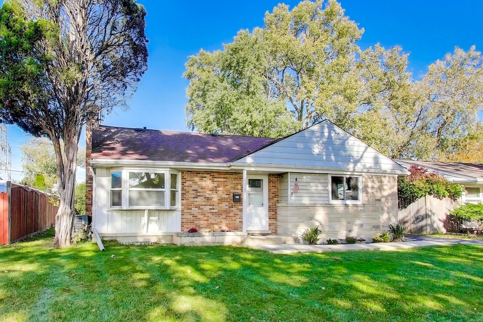
7332 Davis St Morton Grove, IL 60053
Estimated payment $2,859/month
Highlights
- Very Popular Property
- Wood Flooring
- Laundry Room
- Maine East High School Rated A
- Patio
- 4-minute walk to Oketo Park
About This Home
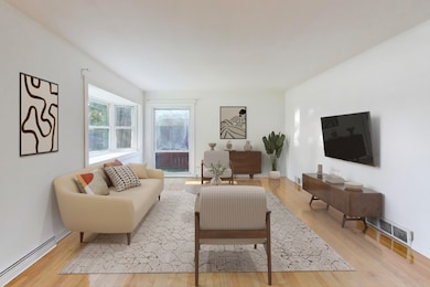
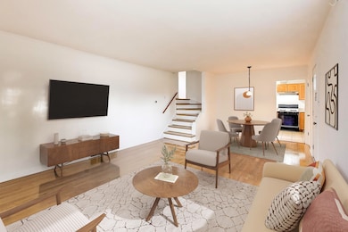
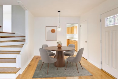
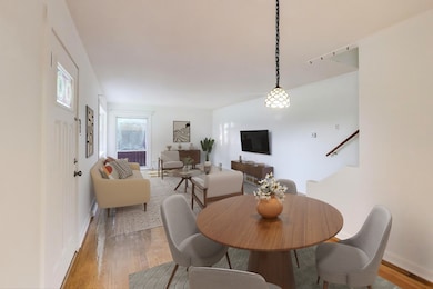
Welcome to this fabulous sun-filled 3-bedroom, 2-bathroom split-level home, perfectly situated on a quiet, winding street in highly desirable Morton Grove. This charming residence combines classic design with modern functionality, making it ideal for comfortable living. Step inside to discover oak hardwood floors throughout the main and second floors, offering timeless elegance and warmth. The bright and airy living room seamlessly flows into the dining area, creating an inviting space perfect for gatherings and everyday living. The second level features three spacious bedrooms, each filled with natural light, along with a well-appointed bathroom for your convenience. The lower level serves as a great family room or TV room, complete with a full bathroom, making it an ideal spot for relaxation and entertainment. Additionally, the unfinished basement, which includes a laundry area, is ready for your creative ideas to transform it into a personalized space-be it a home gym, workshop, or additional storage. Outside, the property boasts an enormous backyard, perfect for outdoor activities and gatherings. The one-car garage with a covered side patio provides both practicality and a lovely space to enjoy the outdoors, regardless of the weather. This home is a canvas awaiting your personal touch. Embrace the opportunity to make it your own and create wonderful memories in this delightful setting!
Home Details
Home Type
- Single Family
Est. Annual Taxes
- $8,387
Year Built
- Built in 1954
Lot Details
- Lot Dimensions are 55 x 145
- Fenced
- Paved or Partially Paved Lot
Parking
- 1 Car Garage
- Driveway
Home Design
- Bi-Level Home
- Split Level with Sub
- Brick Exterior Construction
- Asphalt Roof
- Stone Siding
Interior Spaces
- 2,265 Sq Ft Home
- Family Room
- Combination Dining and Living Room
- Unfinished Attic
- Carbon Monoxide Detectors
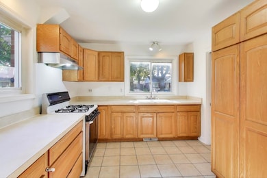
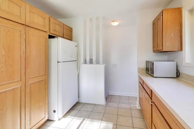
Kitchen
- Range
- Microwave
Flooring
- Wood
- Ceramic Tile
Bedrooms and Bathrooms
- 3 Bedrooms
- 3 Potential Bedrooms
- 2 Full Bathrooms
Laundry
- Laundry Room
- Dryer
- Washer
Basement
- Partial Basement
- Finished Basement Bathroom
Outdoor Features
- Patio
Schools
- Melzer Elementary School
- Gemini Junior High School
- Maine East High School
Utilities
- Forced Air Heating System
- Heating System Uses Natural Gas
- Lake Michigan Water
- Cable TV Available
Community Details
- Split Level
Map
Home Values in the Area
Average Home Value in this Area
Tax History
| Year | Tax Paid | Tax Assessment Tax Assessment Total Assessment is a certain percentage of the fair market value that is determined by local assessors to be the total taxable value of land and additions on the property. | Land | Improvement |
|---|---|---|---|---|
| 2024 | $8,387 | $31,000 | $8,470 | $22,530 |
| 2023 | $8,000 | $31,000 | $8,470 | $22,530 |
| 2022 | $8,000 | $31,000 | $8,470 | $22,530 |
| 2021 | $8,603 | $27,891 | $5,967 | $21,924 |
| 2020 | $8,358 | $27,891 | $5,967 | $21,924 |
| 2019 | $7,240 | $30,991 | $5,967 | $25,024 |
| 2018 | $6,439 | $25,458 | $5,197 | $20,261 |
| 2017 | $6,344 | $25,458 | $5,197 | $20,261 |
| 2016 | $6,160 | $25,458 | $5,197 | $20,261 |
| 2015 | $6,032 | $23,168 | $4,427 | $18,741 |
| 2014 | $5,906 | $23,168 | $4,427 | $18,741 |
| 2013 | $5,740 | $23,168 | $4,427 | $18,741 |
Property History
| Date | Event | Price | List to Sale | Price per Sq Ft |
|---|---|---|---|---|
| 11/11/2025 11/11/25 | Pending | -- | -- | -- |
| 11/07/2025 11/07/25 | For Sale | $409,900 | -- | $181 / Sq Ft |
Purchase History
| Date | Type | Sale Price | Title Company |
|---|---|---|---|
| Deed | $272,000 | Cti | |
| Interfamily Deed Transfer | -- | None Available |
Mortgage History
| Date | Status | Loan Amount | Loan Type |
|---|---|---|---|
| Open | $190,400 | New Conventional |
Source: Midwest Real Estate Data (MRED)
MLS Number: 12513474
APN: 09-13-408-031-0000
Disclaimer: Certain information contained herein is derived from information provided by parties other than Homes.com. All information provided is deemed reliable, but is not guaranteed to be accurate and should be independently verified.
![]() Based on information submitted to the MLS GRID. All data is obtained from various sources and may not have been verified by broker or MLS GRID. Supplied Open House Information is subject to change without notice. All information should be independently reviewed and verified for accuracy. Properties may or may not be listed by the office/agent presenting the information. Some IDX listings have been excluded from this website.
Based on information submitted to the MLS GRID. All data is obtained from various sources and may not have been verified by broker or MLS GRID. Supplied Open House Information is subject to change without notice. All information should be independently reviewed and verified for accuracy. Properties may or may not be listed by the office/agent presenting the information. Some IDX listings have been excluded from this website.
The Digital Millennium Copyright Act of 1998, 17 U.S.C. § 512 (the “DMCA”) provides recourse for copyright owners who believe that material appearing on the Internet infringes their rights under U.S. copyright law. If you believe in good faith that any content or material made available in connection with our website or services infringes your copyright, you (or your agent) may send us a notice requesting that the content or material be removed, or access to it blocked.
Notices must be sent in writing by email to DMCAnotice@MLSGrid.com.
The DMCA requires that your notice of alleged copyright infringement include the following information:
(1) description of the copyrighted work that is the subject of claimed infringement;
(2) description of the alleged infringing content and information sufficient to permit us to locate the content;
(3) contact information for you, including your address, telephone number and email address;
(4) a statement by you that you have a good faith belief that the content in the manner complained of is not authorized by the copyright owner, or its agent, or by the operation of any law;
(5) a statement by you, signed under penalty of perjury, that the information in the notification is accurate and that you have the authority to enforce the copyrights that are claimed to be infringed; and
(6) a physical or electronic signature of the copyright owner or a person authorized to act on the copyright owner’s behalf. Failure to include all of the above information may result in the delay of the processing of your complaint.
- 7343 Lake St
- 7207 Church St
- 7303 Ponto Dr
- 9043 Oriole Ave
- 7302 Ponto Dr
- 7215 Lyons St
- 9327 Oriole Ave
- 8760 N Oketo Ave
- 8927 Belleforte Ave
- 9400 Octavia Ave
- 7701 Lake St
- 7434 Emerson St
- 7713 Arcadia St
- 7014 Church St
- 9216 Ozark St
- 8936 Ozark Ave
- 7349 W Crain St
- 8836 Sayre Ave
- 7710 Dempster St Unit 204
- 6727 Beckwith Rd
