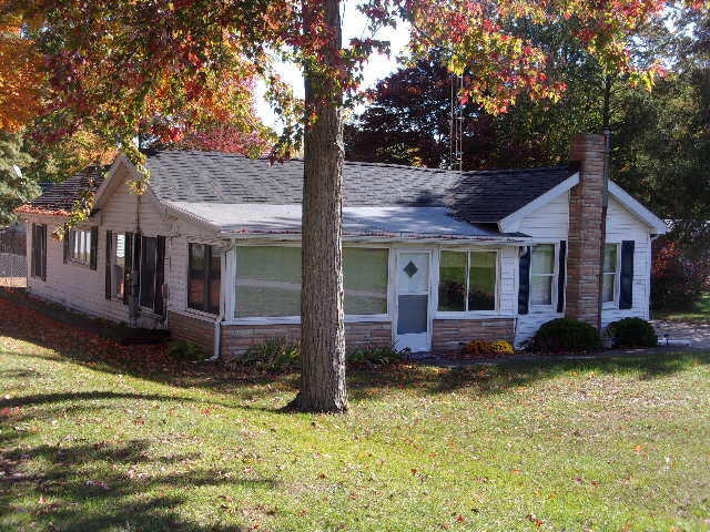
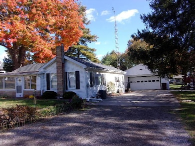
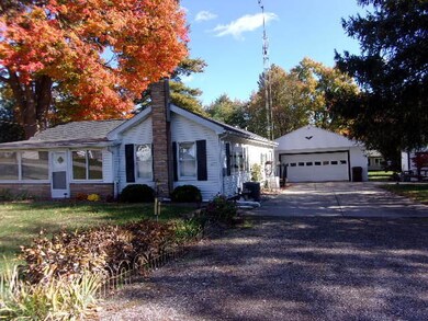
7337 Union St Adrian, MI 49221
Estimated payment $1,053/month
Highlights
- Wood Flooring
- 2 Car Detached Garage
- Patio
- No HOA
- Porch
- Forced Air Heating and Cooling System
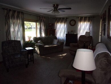
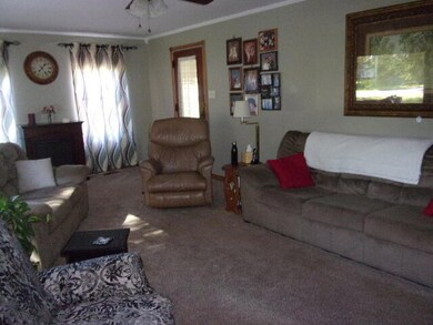
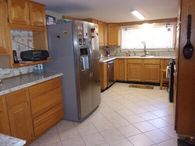
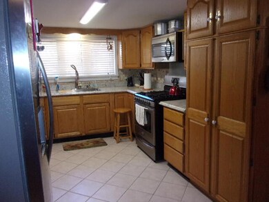
About This Home
Adorable 2-3 bedroom, 2 bath home in the village of Fairfield. Separate dining room, main floor laundry. Enclosed front porch that is heated and cooled so you can enjoy your porch all year long. 3rd bedroom is currently used as a closet. 2 car detached garage. 2 storage sheds. Generator ready. Fenced in back yard.
Home Details
Home Type
- Single Family
Est. Annual Taxes
- $220
Year Built
- Built in 1940
Lot Details
- 0.28 Acre Lot
- Lot Dimensions are 94x132
- Back Yard Fenced
Parking
- 2 Car Detached Garage
- Garage Door Opener
Home Design
- Asphalt Roof
- Vinyl Siding
Interior Spaces
- 2 Main Level Bedrooms
- 1,356 Sq Ft Home
- 1-Story Property
Kitchen
- Oven
- Range
- Microwave
- Dishwasher
Flooring
- Wood
- Carpet
- Ceramic Tile
Laundry
- Laundry on main level
- Dryer
- Washer
Basement
- Michigan Basement
- Crawl Space
Outdoor Features
- Patio
- Porch
Utilities
- Forced Air Heating and Cooling System
- Heating System Uses Natural Gas
- Well
- Natural Gas Water Heater
- Water Softener is Owned
Community Details
- No Home Owners Association
Map
Home Values in the Area
Average Home Value in this Area
Tax History
| Year | Tax Paid | Tax Assessment Tax Assessment Total Assessment is a certain percentage of the fair market value that is determined by local assessors to be the total taxable value of land and additions on the property. | Land | Improvement |
|---|---|---|---|---|
| 2025 | $220 | $71,400 | $0 | $0 |
| 2024 | $216 | $64,700 | $0 | $0 |
| 2022 | $1,180 | $47,200 | $0 | $0 |
| 2021 | $1,167 | $42,400 | $0 | $0 |
| 2020 | $1,167 | $43,900 | $0 | $0 |
| 2019 | $96,688 | $35,800 | $0 | $0 |
| 2018 | $1,250 | $35,840 | $0 | $0 |
| 2017 | $1,213 | $32,556 | $0 | $0 |
| 2016 | $1,209 | $32,092 | $0 | $0 |
| 2014 | -- | $33,753 | $0 | $0 |
Property History
| Date | Event | Price | List to Sale | Price per Sq Ft |
|---|---|---|---|---|
| 10/30/2025 10/30/25 | Pending | -- | -- | -- |
| 10/22/2025 10/22/25 | For Sale | $196,500 | -- | $145 / Sq Ft |
Purchase History
| Date | Type | Sale Price | Title Company |
|---|---|---|---|
| Quit Claim Deed | -- | None Available | |
| Deed | -- | None Available | |
| Quit Claim Deed | $17,000 | Servicelink | |
| Sheriffs Deed | $82,332 | None Available | |
| Warranty Deed | $99,900 | American Title Company |
Mortgage History
| Date | Status | Loan Amount | Loan Type |
|---|---|---|---|
| Previous Owner | $19,980 | Stand Alone Second | |
| Previous Owner | $79,920 | Adjustable Rate Mortgage/ARM |
Source: MichRIC
MLS Number: 25054245
APN: FAF-450-0060-00
Disclaimer: Certain information contained herein is derived from information provided by parties other than Homes.com. All information provided is deemed reliable, but is not guaranteed to be accurate and should be independently verified.
![]() Information is deemed reliable but not guaranteed.
Information is deemed reliable but not guaranteed.
Copyright 2025 MichRIC, LLC. All rights reserved.
- 7489 Jefferson St
- 1284 Codling Rd
- 8318 Jefferson St
- 5611 S Adrian Hwy
- 4225 Treat Hwy
- 3822 Sharp Rd
- 1704 E Carleton Rd
- 2329 Wood Ridge Dr
- 11057 Arnold Hwy
- 4084 Seneca St
- 4500 Ogden Hwy
- 4070 Sharp Rd
- 31 Saint Clair River Ct
- 1883 Harold St
- 280 San Antonio River Dr
- 3118 Planeview Dr
- 4484 Sharp Rd
- 5000 BLK S Adrian Hwy
- 5000 BLK LOT #1 S Adrian Hwy
- 1902 W Cadmus Rd
