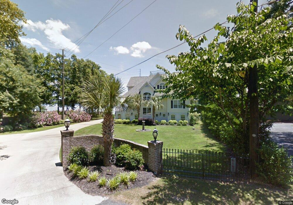
734 Mayflower Trail Chapin, SC 29036
Estimated Value: $510,000 - $1,099,000
6
Beds
3
Baths
1,915
Sq Ft
$412/Sq Ft
Est. Value
About This Home
This home is located at 734 Mayflower Trail, Chapin, SC 29036 and is currently estimated at $789,051, approximately $412 per square foot. 734 Mayflower Trail is a home located in Lexington County with nearby schools including Chapin Elementary School, Chapin Intermediate, and Chapin High School.
Ownership History
Date
Name
Owned For
Owner Type
Purchase Details
Closed on
Oct 11, 2019
Sold by
Carson Richard Stephen and Abercrombie Millicent D
Bought by
Carson Richard Stephens and Carson Millicent D
Current Estimated Value
Home Financials for this Owner
Home Financials are based on the most recent Mortgage that was taken out on this home.
Original Mortgage
$484,350
Outstanding Balance
$421,543
Interest Rate
3.4%
Mortgage Type
New Conventional
Estimated Equity
$367,508
Purchase Details
Closed on
Nov 19, 1999
Sold by
Joye Charles M
Bought by
Carson Richard S
Create a Home Valuation Report for This Property
The Home Valuation Report is an in-depth analysis detailing your home's value as well as a comparison with similar homes in the area
Home Values in the Area
Average Home Value in this Area
Purchase History
| Date | Buyer | Sale Price | Title Company |
|---|---|---|---|
| Carson Richard Stephens | -- | None Available | |
| Carson Richard S | $62,000 | -- |
Source: Public Records
Mortgage History
| Date | Status | Borrower | Loan Amount |
|---|---|---|---|
| Open | Carson Richard Stephens | $484,350 |
Source: Public Records
Tax History
| Year | Tax Paid | Tax Assessment Tax Assessment Total Assessment is a certain percentage of the fair market value that is determined by local assessors to be the total taxable value of land and additions on the property. | Land | Improvement |
|---|---|---|---|---|
| 2024 | $3,663 | $22,230 | $9,190 | $13,040 |
| 2023 | $3,401 | $22,230 | $9,190 | $13,040 |
| 2022 | $3,432 | $22,230 | $9,190 | $13,040 |
| 2020 | $3,594 | $22,230 | $9,190 | $13,040 |
| 2019 | $2,995 | $18,209 | $7,168 | $11,041 |
| 2018 | $2,636 | $18,209 | $7,168 | $11,041 |
| 2017 | $2,568 | $18,209 | $7,168 | $11,041 |
| 2016 | $2,633 | $18,209 | $7,168 | $11,041 |
| 2014 | $2,519 | $17,484 | $6,900 | $10,584 |
| 2013 | -- | $17,490 | $6,900 | $10,590 |
Source: Public Records
Map
Nearby Homes
- 201 Old Cedar Point
- 220 Old Cedar Point
- 404 Lombard Way
- 110 Night Harbor Dr
- 148 Parapet Trail
- 343 Night Harbor Dr
- 0 Green Meadow Dr Unit 617154
- 0 Shamrock Ct Unit 617155
- 1304 Amicks Ferry Rd
- 117 Bogater Rd
- 0 Bogater Rd Unit 626014
- 0 Woodlake Cir
- 124 Quiet Cove Dr
- 530 Misty Banks Dr
- 852 Misty Harbor Rd
- 201 Edgewood Dr
- 537 Misty Banks Dr
- 1040 Refuge Place
- 823 Elms Spinney Ln
- 934 Salisbury Ct
- 730 Mayflower Trail
- 706 Mayflower Trail
- 713 Harborview Ct
- 726 Mayflower Trail
- 709 Harborview Ct
- 712 Harborview Ct
- 722 Mayflower Trail
- 638 Harborview Point
- 718 Mayflower Trail
- 708 Harborview Ct
- 642 Harborview Point
- 704 Harborview Ct
- 714 Mayflower Trail
- 820 Mayflower Ct
- 641 Harborview Point
- 620 Harborview Point
- 721 Mayflower Trail
- 637 Harborview Point
- 633 Harborview Point
- 629 Harborview Point
Your Personal Tour Guide
Ask me questions while you tour the home.