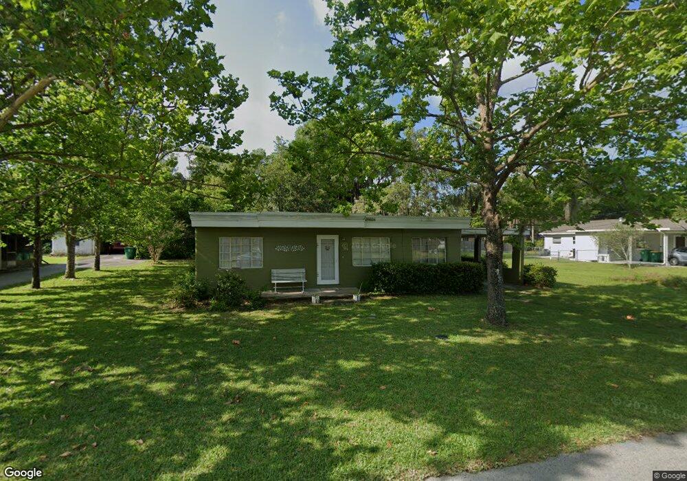
734 W University Ave Deland, FL 32720
Estimated Value: $166,142 - $230,000
2
Beds
1
Bath
874
Sq Ft
$230/Sq Ft
Est. Value
About This Home
This home is located at 734 W University Ave, Deland, FL 32720 and is currently estimated at $201,286, approximately $230 per square foot. 734 W University Ave is a home located in Volusia County with nearby schools including Citrus Grove Elementary, Deland High School, and Southwestern Middle School.
Ownership History
Date
Name
Owned For
Owner Type
Purchase Details
Closed on
Oct 18, 2023
Sold by
Frank Family Trust
Bought by
Montalvo Lisa Frank and Montalvo Emily
Current Estimated Value
Purchase Details
Closed on
Jul 12, 2017
Sold by
Frank Victor and Frank Lois J
Bought by
Frank Victor and Frank Lois June
Purchase Details
Closed on
Nov 15, 1974
Bought by
Frank Lois J
Create a Home Valuation Report for This Property
The Home Valuation Report is an in-depth analysis detailing your home's value as well as a comparison with similar homes in the area
Home Values in the Area
Average Home Value in this Area
Purchase History
| Date | Buyer | Sale Price | Title Company |
|---|---|---|---|
| Montalvo Lisa Frank | $100 | None Listed On Document | |
| Frank Victor | -- | Attorney | |
| Frank Lois J | $14,000 | -- |
Source: Public Records
Tax History Compared to Growth
Tax History
| Year | Tax Paid | Tax Assessment Tax Assessment Total Assessment is a certain percentage of the fair market value that is determined by local assessors to be the total taxable value of land and additions on the property. | Land | Improvement |
|---|---|---|---|---|
| 2025 | $2,041 | $120,473 | $38,664 | $81,809 |
| 2024 | $2,041 | $122,971 | $38,664 | $84,307 |
| 2023 | $2,041 | $122,275 | $38,664 | $83,611 |
| 2022 | $1,898 | $112,834 | $38,664 | $74,170 |
| 2021 | $1,774 | $88,578 | $25,776 | $62,802 |
| 2020 | $1,619 | $80,750 | $24,487 | $56,263 |
| 2019 | $1,569 | $77,882 | $21,704 | $56,178 |
| 2018 | $1,445 | $64,208 | $15,627 | $48,581 |
| 2017 | $1,303 | $58,042 | $15,552 | $42,490 |
| 2016 | $1,160 | $51,567 | $0 | $0 |
| 2015 | $1,079 | $45,475 | $0 | $0 |
| 2014 | $1,032 | $42,495 | $0 | $0 |
Source: Public Records
Map
Nearby Homes
- 748 W Florence Ave
- 718 W Hogle Ave
- 600 N Boundary Ave Unit 119B
- 600 N Boundary Ave Unit 110A
- 600 N Boundary Ave Unit 114-C
- 600 N Boundary Ave Unit 114B
- 600 N Boundary Ave Unit 106-D
- 600 W Hogle Ave
- 727 N Stone St
- 0 W Plymouth Ave
- 807 W Church St
- 236 N Salisbury Ave
- 1126 W Minnesota Ave
- Malory Plan at Delaney Reserve
- Abbey Plan at Delaney Reserve
- 733 Maple Oak Dr
- 1141 Red Buckeye Ct
- 1145 Red Buckeye Ct
- 694 Florida Elm Ct
- 698 Florida Elm Ct
- 531 N High St
- 730 W University Ave
- 713 W May St
- 527 N High St
- 711 W May St
- 735 W University Ave
- 737 W University Ave
- 708 W University Ave
- 731 W University Ave
- 703 W May St
- 729 W University Ave
- 706 W University Ave
- 530 N High St
- 528 N High St
- 760 W May St
- 701 W May St
- 515 N High St
- 725 W University Ave
- 612 N High St
- 524 N High St