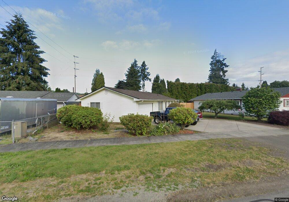
735 4th Ave SW Castle Rock, WA 98611
Estimated Value: $324,329 - $389,000
3
Beds
2
Baths
1,080
Sq Ft
$324/Sq Ft
Est. Value
About This Home
This home is located at 735 4th Ave SW, Castle Rock, WA 98611 and is currently estimated at $350,082, approximately $324 per square foot. 735 4th Ave SW is a home located in Cowlitz County with nearby schools including Castle Rock Elementary School, Castle Rock Middle School, and Castle Rock High School.
Ownership History
Date
Name
Owned For
Owner Type
Purchase Details
Closed on
Aug 16, 2005
Sold by
Mcculley Paul and Mcculley Nora
Bought by
Rocha Angel Molina and Perez Eunice B
Current Estimated Value
Home Financials for this Owner
Home Financials are based on the most recent Mortgage that was taken out on this home.
Original Mortgage
$98,000
Outstanding Balance
$51,149
Interest Rate
5.56%
Mortgage Type
Fannie Mae Freddie Mac
Estimated Equity
$298,933
Create a Home Valuation Report for This Property
The Home Valuation Report is an in-depth analysis detailing your home's value as well as a comparison with similar homes in the area
Home Values in the Area
Average Home Value in this Area
Purchase History
| Date | Buyer | Sale Price | Title Company |
|---|---|---|---|
| Rocha Angel Molina | $125,000 | Stewart Title |
Source: Public Records
Mortgage History
| Date | Status | Borrower | Loan Amount |
|---|---|---|---|
| Open | Rocha Angel Molina | $98,000 |
Source: Public Records
Tax History Compared to Growth
Tax History
| Year | Tax Paid | Tax Assessment Tax Assessment Total Assessment is a certain percentage of the fair market value that is determined by local assessors to be the total taxable value of land and additions on the property. | Land | Improvement |
|---|---|---|---|---|
| 2024 | $2,428 | $286,450 | $50,930 | $235,520 |
| 2023 | $2,164 | $261,760 | $50,930 | $210,830 |
| 2022 | $2,044 | $260,560 | $45,260 | $215,300 |
| 2021 | $1,992 | $222,160 | $39,700 | $182,460 |
| 2020 | $1,581 | $201,950 | $36,090 | $165,860 |
| 2019 | $1,484 | $164,454 | $32,813 | $131,641 |
| 2018 | $1,482 | $144,370 | $32,810 | $111,560 |
| 2017 | $1,287 | $125,430 | $31,250 | $94,180 |
| 2016 | $1,194 | $106,990 | $23,630 | $83,360 |
| 2015 | $1,215 | $104,560 | $23,630 | $80,930 |
| 2013 | -- | $94,010 | $23,630 | $70,380 |
Source: Public Records
Map
Nearby Homes
- 642 5th Ave SW
- 1020 3rd Ave SW
- 546 4th Ave SW
- 705 1st Ave SW
- 56 Shear St SW
- 237 C St SW
- 109 B St SW
- 438 Front Ave SW
- 203 Roake Ave SE
- 6609 Westside Hwy
- 0 Huntington Ave S Unit NWM2336096
- 107 Guinevere Ct
- 114 Cherry St NW
- 0 Pioneer Ave NE
- 552 North St NE
- 611 Pioneer Ave NE
- 715 NE Pioneer Ave NE
- 110 Dryad Ln
- 410 Hicks Rd
- 3820 Westside Hwy
- 725 4th Ave SW
- 809 4th Ave SW
- 823 4th Ave SW
- 454 Hibbard Lp SW
- 432 Diane St SW
- 742 5th Ave SW
- 732 4th Ave SW
- 448 Diane St SW
- 820 4th Ave SW
- 645 4th Ave SW
- 454 Hibbard St SW
- 354 Shear St SW
- 456 Diane St SW
- 338 Shear St SW
- 411 Shear St SW
- 457 Hibbard St SW
- 629 4th Ave SW
- 433 Diane St SW
- 328 Aden St SW
- 825 3rd Ave SW