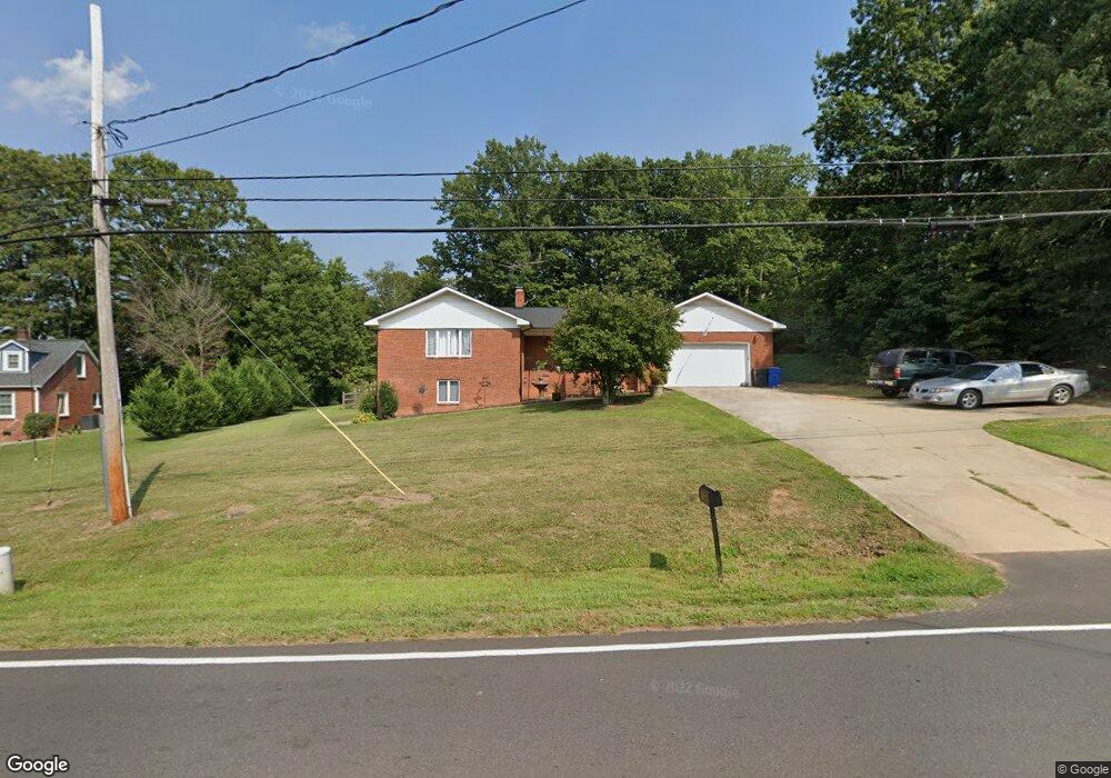
735 Perth Rd Troutman, NC 28166
Estimated Value: $426,000 - $615,070
3
Beds
3
Baths
2,852
Sq Ft
$183/Sq Ft
Est. Value
About This Home
This home is located at 735 Perth Rd, Troutman, NC 28166 and is currently estimated at $522,268, approximately $183 per square foot. 735 Perth Rd is a home located in Iredell County with nearby schools including Troutman Elementary School, Troutman Middle School, and South Iredell High School.
Ownership History
Date
Name
Owned For
Owner Type
Purchase Details
Closed on
Oct 30, 2017
Sold by
Ott Cory J
Bought by
Clayton Cornell Jason and Walsh Kathleen E
Current Estimated Value
Home Financials for this Owner
Home Financials are based on the most recent Mortgage that was taken out on this home.
Original Mortgage
$209,200
Outstanding Balance
$174,974
Interest Rate
3.78%
Mortgage Type
New Conventional
Estimated Equity
$347,294
Purchase Details
Closed on
Feb 17, 2012
Sold by
Brown Denise M and Brown Denise Garnettte
Bought by
Garnette John E
Home Financials for this Owner
Home Financials are based on the most recent Mortgage that was taken out on this home.
Original Mortgage
$103,000
Interest Rate
3.89%
Mortgage Type
Future Advance Clause Open End Mortgage
Create a Home Valuation Report for This Property
The Home Valuation Report is an in-depth analysis detailing your home's value as well as a comparison with similar homes in the area
Home Values in the Area
Average Home Value in this Area
Purchase History
| Date | Buyer | Sale Price | Title Company |
|---|---|---|---|
| Clayton Cornell Jason | $240,000 | None Available | |
| Garnette John E | $100,000 | Chicago Title Ins Co |
Source: Public Records
Mortgage History
| Date | Status | Borrower | Loan Amount |
|---|---|---|---|
| Open | Clayton Cornell Jason | $209,200 | |
| Previous Owner | Garnette John E | $103,000 |
Source: Public Records
Tax History Compared to Growth
Tax History
| Year | Tax Paid | Tax Assessment Tax Assessment Total Assessment is a certain percentage of the fair market value that is determined by local assessors to be the total taxable value of land and additions on the property. | Land | Improvement |
|---|---|---|---|---|
| 2024 | $2,835 | $462,490 | $112,700 | $349,790 |
| 2023 | $2,835 | $408,340 | $112,700 | $295,640 |
| 2022 | $1,680 | $254,160 | $87,610 | $166,550 |
| 2021 | $1,651 | $254,160 | $87,610 | $166,550 |
| 2020 | $1,651 | $254,160 | $87,610 | $166,550 |
| 2019 | $1,587 | $254,160 | $87,610 | $166,550 |
| 2018 | $1,438 | $231,890 | $80,310 | $151,580 |
Source: Public Records
Map
Nearby Homes
- 132 Quail Haven Dr
- 678 Wagner St
- 131 Quail Haven Dr
- 505 York Rd
- 145 Quail Haven Dr
- Bristol Plan at Brookside
- Arlington Plan at Brookside
- Clifton Plan at Brookside
- Claiborne Plan at Brookside
- Azalea Plan at Brookside
- 502 York Rd
- 118 N Hill Ln
- Hanover Plan at Calvin Creek
- Cali Plan at Calvin Creek
- Biltmore Plan at Calvin Creek
- Winston Plan at Calvin Creek
- Hamilton Plan at Calvin Creek
- Hayden Plan at Calvin Creek
- Penwell Plan at Calvin Creek
- Wilmington Plan at Calvin Creek
- 729 Perth Rd
- 745 Perth Rd
- 725 Perth Rd
- 735 Georgie St
- 731 Georgie St
- 742 Perth Rd
- 727 Georgie St
- 746 Perth Rd
- 723 Georgie St
- 755 Perth Rd
- 743 Georgie St
- 743 Georgie St Unit 35
- 719 Georgie St
- 719 Georgie St Unit 5
- 752 Perth Rd
- 114 Quail Haven Dr
- 732 Georgie St
- 728 Georgie St
- 747 Georgie St
- 120 Quail Haven Dr