
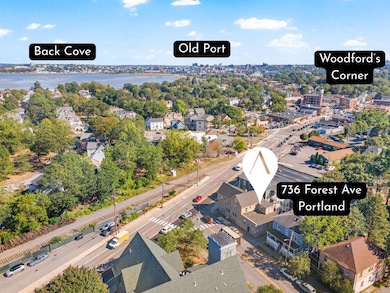
736 Forest Ave Portland, ME 04103
Deering Center NeighborhoodEstimated payment $5,489/month
Highlights
- Property is near public transit
- Wood Flooring
- Corner Lot
- Longfellow School-Portland Rated 10
- New Englander Architecture
- 4-minute walk to Heseltine Park
About This Home
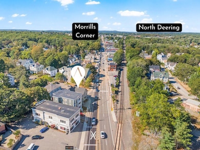
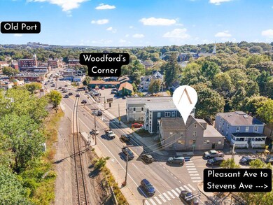
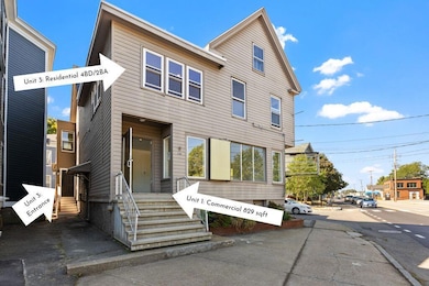
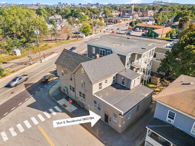
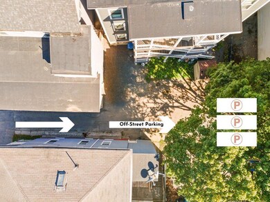
High-visibility property in the Mixed Use Zone B-2B, located on the corner of Forest Ave & Pleasant Ave, just north of Woodford's Corner. The property offers a first-floor 829 SF commercial corner suite with approx 35,000+ cars/day traffic count - ideal for retail, office, salon/barber, and other permitted uses (see land use docs). The upper levels contain two vacant, fully renovated residential units with separate entrances: a 2BD/1BA (945 SF, projected rent $2,750/month) and a 4BD/2BA (1,766 SF, projected rent $3,9000/month). Strong rental demand and modern finishes position these units for immediate occupancy. Additional features include off-street parking for 3 vehicles, abundant street parking, and direct access to public transportation. Strategic location minutes from I-295 and downtown Portland, and within half a mile of Back Cove, Stevens Ave Deering neighborhood (Norimoto Bakery, Rambler Café, Pat's Meat Market), and Woodfords Corner amenities. A flexible investment opportunity suitable for owner-occupiers or investors seeking a mixed-use property with strong signage visibility and cash flow potential. Also listed as COMMERCIAL MLS#: 1638190
Property Details
Home Type
- Multi-Family
Est. Annual Taxes
- $9,005
Year Built
- Built in 1900
Lot Details
- 3,920 Sq Ft Lot
- Corner Lot
Home Design
- New Englander Architecture
- Brick Foundation
- Concrete Foundation
- Wood Frame Construction
- Shingle Roof
- Aluminum Siding
- Concrete Perimeter Foundation
Interior Spaces
- 3,540 Sq Ft Home
- 3-Story Property
- Wood Flooring
Unfinished Basement
- Basement Fills Entire Space Under The House
- Interior Basement Entry
Parking
- Driveway
- Paved Parking
- On-Site Parking
Location
- Property is near public transit
Utilities
- No Cooling
- Heating System Uses Natural Gas
- Heating System Mounted To A Wall or Window
- Electric Water Heater
Community Details
- No Home Owners Association
- 3 Units
Listing and Financial Details
- Tax Lot 18
- Assessor Parcel Number PTLD-000130-H000018-000001
Map
Home Values in the Area
Average Home Value in this Area
Tax History
| Year | Tax Paid | Tax Assessment Tax Assessment Total Assessment is a certain percentage of the fair market value that is determined by local assessors to be the total taxable value of land and additions on the property. | Land | Improvement |
|---|---|---|---|---|
| 2024 | $10,617 | $707,300 | $161,100 | $546,200 |
| 2023 | $10,192 | $707,300 | $161,100 | $546,200 |
| 2022 | $9,626 | $707,300 | $161,100 | $546,200 |
| 2021 | $9,188 | $707,300 | $161,100 | $546,200 |
| 2020 | $7,324 | $314,200 | $92,100 | $222,100 |
| 2019 | $7,324 | $314,200 | $92,100 | $222,100 |
| 2018 | $6,811 | $315,300 | $92,100 | $223,200 |
| 2017 | $6,826 | $315,300 | $92,100 | $223,200 |
| 2016 | $6,656 | $315,300 | $92,100 | $223,200 |
| 2015 | $6,505 | $315,300 | $92,100 | $223,200 |
| 2014 | $6,306 | $315,300 | $92,100 | $223,200 |
Property History
| Date | Event | Price | List to Sale | Price per Sq Ft |
|---|---|---|---|---|
| 09/19/2025 09/19/25 | For Sale | $899,000 | -- | $254 / Sq Ft |
Purchase History
| Date | Type | Sale Price | Title Company |
|---|---|---|---|
| Interfamily Deed Transfer | -- | -- |
Mortgage History
| Date | Status | Loan Amount | Loan Type |
|---|---|---|---|
| Closed | $225,000 | Commercial |
Source: Maine Listings
MLS Number: 1638196
APN: PTLD-000130-000000-H018001
Disclaimer: Certain information contained herein is derived from information provided by parties other than Homes.com. All information provided is deemed reliable, but is not guaranteed to be accurate and should be independently verified.
![]() Listing data is derived in whole or in part from Maine Real Estate Information System, Inc. (d/b/a Maine Listings) and is for consumers' personal, noncommercial use only. Dimensions are approximate and not guaranteed. All data should be independently verified.
Listing data is derived in whole or in part from Maine Real Estate Information System, Inc. (d/b/a Maine Listings) and is for consumers' personal, noncommercial use only. Dimensions are approximate and not guaranteed. All data should be independently verified.
© 2025 Maine Real Estate Information System, Inc. All Rights Reserved. Equal Housing Opportunity.
Homes.com, LLC, 17600 Laguna Canyon Rd Irvine, CA 92618 (888)-952-6393
![]()
- 25 Pleasant Ave
- 44 Pleasant Ave
- 24 Hartley St
- 27 Norwood St
- 44 Hersey St
- 33 Mayland St
- 33 Bay View Dr
- 89 Clinton St
- 611 Forest Ave
- 147 Pleasant Ave Unit 2
- 27 Rackleff St
- 48 Ashmont St
- 37 Tremont St
- 14 Prospect St
- 930 Forest Ave
- 202 Pleasant Ave
- 65 Mcauley Way Unit 506
- 37 Wellington Rd
- 75 Mcauley Way Unit 307
- 75 Mcauley Way Unit 206
- 8 Pleasant Ave Unit 1
- 46 Saunders St Unit FLOOR 1
- 207 Coyle St Unit 4
- 147 Pleasant Ave
- 509 Forest Ave
- 100 Forest Park
- 151 Dartmouth St
- 166 Massachusetts Ave Unit Apartment 2
- 21 Fessenden St Unit 19-1
- 1060 Forest Ave Unit 2
- 194 Falmouth St Unit 1
- 46A Tamarlane
- 240 Harvard St
- 132 Marginal Way
- 31 Forest St Unit 1
- 27 Frederic St Unit B
- 69 Maggie Ln
- 1006 Congress St
- 583 Washington Ave Unit 2
- 117 Preble St
