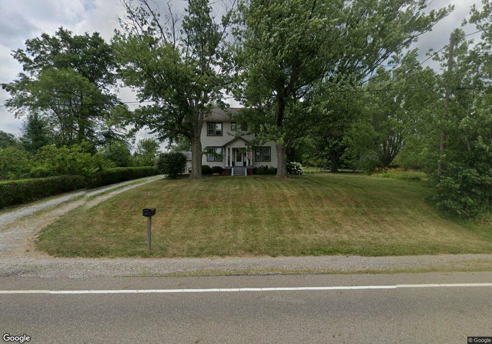
7365 Columbus Rd Louisville, OH 44641
Estimated Value: $208,000 - $270,000
3
Beds
2
Baths
1,656
Sq Ft
$140/Sq Ft
Est. Value
About This Home
This home is located at 7365 Columbus Rd, Louisville, OH 44641 and is currently estimated at $231,136, approximately $139 per square foot. 7365 Columbus Rd is a home located in Stark County with nearby schools including Louisville High School and St. Thomas Aquinas High School & Middle School.
Ownership History
Date
Name
Owned For
Owner Type
Purchase Details
Closed on
Jul 30, 2020
Sold by
Marchand Thomas and Marchand Kim
Bought by
Miterko Jeffery Dale and Miterko Patricia Sue
Current Estimated Value
Purchase Details
Closed on
Dec 19, 2019
Sold by
Estate Of H Lawrence Marchand
Bought by
Marchand Stephen M and Marchand Gregory A
Purchase Details
Closed on
Nov 18, 2019
Sold by
Estate Of Elizabeth A Marchand
Bought by
Marchand H Lawrence
Create a Home Valuation Report for This Property
The Home Valuation Report is an in-depth analysis detailing your home's value as well as a comparison with similar homes in the area
Home Values in the Area
Average Home Value in this Area
Purchase History
| Date | Buyer | Sale Price | Title Company |
|---|---|---|---|
| Miterko Jeffery Dale | $138,000 | Multiple | |
| Marchand Stephen M | -- | None Available | |
| Marchand H Lawrence | -- | None Available |
Source: Public Records
Tax History Compared to Growth
Tax History
| Year | Tax Paid | Tax Assessment Tax Assessment Total Assessment is a certain percentage of the fair market value that is determined by local assessors to be the total taxable value of land and additions on the property. | Land | Improvement |
|---|---|---|---|---|
| 2025 | -- | $57,260 | $27,160 | $30,100 |
| 2024 | -- | $57,260 | $27,160 | $30,100 |
| 2023 | $2,153 | $43,260 | $20,650 | $22,610 |
| 2022 | $2,159 | $43,260 | $20,650 | $22,610 |
| 2021 | $2,165 | $43,260 | $20,650 | $22,610 |
| 2020 | $1,750 | $36,820 | $17,710 | $19,110 |
| 2019 | $1,318 | $36,830 | $17,710 | $19,120 |
| 2018 | $1,315 | $36,830 | $17,710 | $19,120 |
| 2017 | $1,113 | $31,410 | $15,650 | $15,760 |
| 2016 | $1,088 | $31,410 | $15,650 | $15,760 |
| 2015 | $1,091 | $31,410 | $15,650 | $15,760 |
| 2014 | $1,051 | $28,930 | $14,390 | $14,540 |
| 2013 | $529 | $28,930 | $14,390 | $14,540 |
Source: Public Records
Map
Nearby Homes
- 7844 Morningstar Dr
- 6285 California Ave
- 6079 Eastlawn St NE
- 6150 Pilot View Cir
- 3580 Brookridge Ave Lot 15
- 5474 Ravenna Ave
- 5700 Glena St
- 0 Glenbar St
- 0 Brookridge Ave
- 524 Glenbar St
- 0 Pilot Knob Ave NE
- 614 Reno Dr
- 1561 Noel St
- 316 E Reno Dr
- 6052 N Nickelplate St
- 428 Honeycrisp Dr NE
- 3047 Mcintosh Dr NE
- 432 Honeycrisp Dr NE
- 2962 Mcintosh Dr NE
- 2963 Mcintosh Dr NE
- 7365 Columbus Rd NE
- 7370 Columbus Rd
- 7341 Columbus Rd
- 7370 Columbus Rd NE
- 7346 Columbus Rd
- 7312 Columbus Rd NE
- 0 Columbus Rd NE
- 7284 Columbus Rd NE
- 7203 Ravenna Ave
- 7272 Columbus Rd
- 7115 Ravenna Ave
- 7085 Ravenna Ave
- 7069 Ravenna Ave
- 7059 Ravenna Ave
- 7512 Columbus Rd NE
- 7106 Ravenna Ave
- 7025 Ravenna Ave
- 7519 Columbus Rd
- 7519 Columbus Rd NE
- 7005 Ravenna Ave