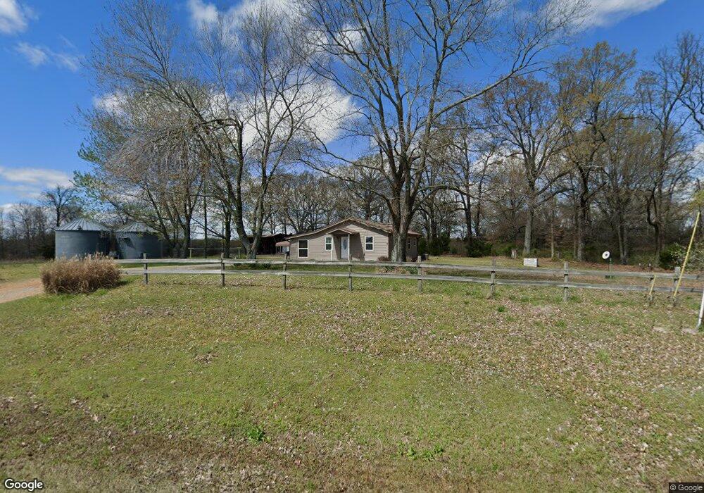
7369 Cord Rd Newark, AR 72562
Estimated Value: $51,543 - $258,000
2
Beds
1
Bath
1,292
Sq Ft
$100/Sq Ft
Est. Value
About This Home
This home is located at 7369 Cord Rd, Newark, AR 72562 and is currently estimated at $128,636, approximately $99 per square foot. 7369 Cord Rd is a home located in Independence County with nearby schools including Cord-Charlotte Elementary School and Cedar Ridge High School.
Ownership History
Date
Name
Owned For
Owner Type
Purchase Details
Closed on
Aug 26, 2020
Sold by
Bromley Kenneth and Bromley Lou Ellen
Bought by
Bromley Travis and Bromley Casey
Current Estimated Value
Home Financials for this Owner
Home Financials are based on the most recent Mortgage that was taken out on this home.
Original Mortgage
$44,000
Interest Rate
3%
Mortgage Type
Construction
Purchase Details
Closed on
Jul 23, 2007
Sold by
Bromley Louellen
Bought by
Bromley Kenneth
Create a Home Valuation Report for This Property
The Home Valuation Report is an in-depth analysis detailing your home's value as well as a comparison with similar homes in the area
Home Values in the Area
Average Home Value in this Area
Purchase History
| Date | Buyer | Sale Price | Title Company |
|---|---|---|---|
| Bromley Travis | $27,864 | None Available | |
| Bromley Kenneth | $50,000 | -- | |
| Bromley Kenneth | $50,000 | -- |
Source: Public Records
Mortgage History
| Date | Status | Borrower | Loan Amount |
|---|---|---|---|
| Closed | Bromley Travis | $44,000 |
Source: Public Records
Tax History Compared to Growth
Tax History
| Year | Tax Paid | Tax Assessment Tax Assessment Total Assessment is a certain percentage of the fair market value that is determined by local assessors to be the total taxable value of land and additions on the property. | Land | Improvement |
|---|---|---|---|---|
| 2024 | $65 | $6,490 | $710 | $5,780 |
| 2023 | $65 | $6,490 | $710 | $5,780 |
| 2022 | $65 | $6,490 | $710 | $5,780 |
| 2021 | $65 | $6,490 | $710 | $5,780 |
| 2020 | $65 | $6,490 | $710 | $5,780 |
| 2019 | $286 | $6,120 | $620 | $5,500 |
| 2018 | $286 | $6,120 | $620 | $5,500 |
| 2017 | $286 | $6,120 | $620 | $5,500 |
| 2016 | $286 | $6,120 | $620 | $5,500 |
| 2015 | $286 | $6,120 | $620 | $5,500 |
| 2014 | $289 | $6,180 | $710 | $5,470 |
Source: Public Records
Map
Nearby Homes
- 701 Wpa Rd
- 6118 Cord Rd
- 5976 and 5980 Cord Rd Rd
- 105 Walden Rd
- 15 Hawks Run
- 400 Weaver Ln
- 70 and 76 Crow Ln
- 250 Summerset Ln
- 1962 acres Upper Lockhart Rd
- 1962 Upper Lockhart Rd
- 195 Cee Jay Ln
- 1700 Sanders Rd
- 6820 White Dr
- 00 Kirby Ln
- 14 Law 351
- 749 Molly Ln
- 112 E 7th St
- 251 Coronado Ln
- 307 College St
- 183 Law 352 Strawberry
- 85 Lick Creek Rd
- 7570 Cord Rd
- 370 Lick Creek 1o9erh426jp1
- 10 Aldrich Ln
- 0 Lick Creek & Anderson Hill Rd Unit 9-517
- 7450 Cord Rd
- 175 Lick Creek Rd
- 0 Wpa Rd Unit 9-518
- 0 Wpa Rd
- 7530 Cord Rd
- 0 State Highway 122
- 7559 Cord Rd
- 7519 Cord Rd
- 55 Otter Lake Rd
- 49 Aldrich
- 0 Anderson Hill Rd Unit 9-516
- 0 Anderson Hill Rd
- 0 Anderson Hill Rd
- 0 Lick Creek Rd
- 355 Otter Lake Rd