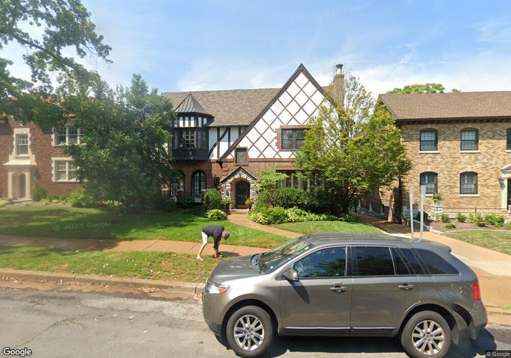
7369 Pershing Ave Saint Louis, MO 63130
Estimated Value: $329,000 - $508,000
2
Beds
2
Baths
1,711
Sq Ft
$230/Sq Ft
Est. Value
About This Home
This home is located at 7369 Pershing Ave, Saint Louis, MO 63130 and is currently estimated at $394,333, approximately $230 per square foot. 7369 Pershing Ave is a home located in St. Louis County with nearby schools including Flynn Park Elementary, Brittany Woods Middle School, and University City High School.
Ownership History
Date
Name
Owned For
Owner Type
Purchase Details
Closed on
Sep 26, 2005
Sold by
Griffin Nathaniel M and Griffin Jane B
Bought by
Griffin Nathaniel M and Griffin Jane B
Current Estimated Value
Purchase Details
Closed on
Jan 24, 2000
Sold by
Mccarthy Miller Ellen and Mccarthy Rodger
Bought by
Griffin Nathaniel M and Griffin Jane B
Home Financials for this Owner
Home Financials are based on the most recent Mortgage that was taken out on this home.
Original Mortgage
$96,000
Outstanding Balance
$29,053
Interest Rate
7.86%
Estimated Equity
$365,280
Create a Home Valuation Report for This Property
The Home Valuation Report is an in-depth analysis detailing your home's value as well as a comparison with similar homes in the area
Home Values in the Area
Average Home Value in this Area
Purchase History
| Date | Buyer | Sale Price | Title Company |
|---|---|---|---|
| Griffin Nathaniel M | -- | -- | |
| Griffin Nathaniel M | $120,000 | -- |
Source: Public Records
Mortgage History
| Date | Status | Borrower | Loan Amount |
|---|---|---|---|
| Open | Griffin Nathaniel M | $96,000 |
Source: Public Records
Tax History
| Year | Tax Paid | Tax Assessment Tax Assessment Total Assessment is a certain percentage of the fair market value that is determined by local assessors to be the total taxable value of land and additions on the property. | Land | Improvement |
|---|---|---|---|---|
| 2025 | $3,764 | $48,580 | $15,600 | $32,980 |
| 2024 | $3,764 | $53,180 | $8,950 | $44,230 |
| 2023 | $3,760 | $53,180 | $8,950 | $44,230 |
| 2022 | $3,710 | $48,930 | $14,310 | $34,620 |
| 2021 | $3,672 | $48,930 | $14,310 | $34,620 |
| 2020 | $3,167 | $41,070 | $11,700 | $29,370 |
| 2019 | $3,168 | $41,070 | $11,700 | $29,370 |
| 2018 | $3,114 | $37,320 | $8,950 | $28,370 |
Source: Public Records
Map
Nearby Homes
- 7330 Kingsbury Blvd
- 524 Warren Ave
- 7298 Greenway Ave
- 7441 Kingsbury Blvd
- 7224 Pershing Ave
- 7530 Maryland Ave
- 7347 Delmar Blvd
- 448 N Hanley Rd
- 7484 Stratford Ave
- 7354 Princeton Ave
- 7320 Forsyth Blvd Unit 204
- 7144 Waterman Ave
- 7498 Teasdale Ave
- 7342 Cornell Ave
- 7249 Forsyth Blvd
- 7526 Washington Ave
- 7360 Stanford Ave
- 150 Carondelet Plaza Unit 1701
- 8 Carrswold Dr
- 7435 Cornell Ave
- 7369 Pershing Ave Unit 2W
- 7369 Pershing Ave Unit 1W
- 7369 Pershing Ave Unit 2E
- 7373 Pershing Ave Unit 1W
- 7373 Pershing Ave Unit 1E
- 7373 Pershing Ave Unit 2E
- 7373 Pershing Ave Unit 2W
- 7365 Pershing Ave
- 7379 Pershing Ave Unit 1E
- 7379 Pershing Ave Unit 2E
- 7379 Pershing Ave Unit 2W
- 7379 Pershing Ave Unit 1W
- 7361 Pershing Ave
- 7356 Kingsbury Blvd
- 7366 Kingsbury Blvd
- 7352 Kingsbury Blvd
- 7370 Kingsbury Blvd
- 7355 Pershing Ave
- 7385 Pershing Ave Unit 1
- 7385 Pershing Ave Unit 2
Your Personal Tour Guide
Ask me questions while you tour the home.