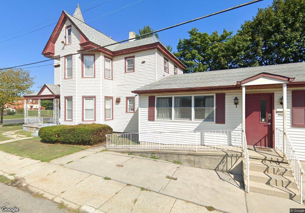
737 Billings Ave Paulsboro, NJ 08066
Estimated Value: $279,000 - $337,000
4
Beds
2
Baths
3,262
Sq Ft
$96/Sq Ft
Est. Value
About This Home
This home is located at 737 Billings Ave, Paulsboro, NJ 08066 and is currently estimated at $312,619, approximately $95 per square foot. 737 Billings Ave is a home located in Gloucester County with nearby schools including Billingsport Elementary School, Loudenslager Elementary School, and Paulsboro High School.
Ownership History
Date
Name
Owned For
Owner Type
Purchase Details
Closed on
Nov 29, 2021
Sold by
3D Railway Services Llc
Bought by
Elshiva Property Ventures Llc
Current Estimated Value
Purchase Details
Closed on
Nov 12, 2009
Sold by
Krauss David
Bought by
3D Railway Services Llc
Purchase Details
Closed on
Jun 4, 2008
Sold by
Zack Minnie
Bought by
Krauss David
Create a Home Valuation Report for This Property
The Home Valuation Report is an in-depth analysis detailing your home's value as well as a comparison with similar homes in the area
Home Values in the Area
Average Home Value in this Area
Purchase History
| Date | Buyer | Sale Price | Title Company |
|---|---|---|---|
| Elshiva Property Ventures Llc | $210,000 | National Integrity Llc | |
| 3D Railway Services Llc | $160,000 | Fidelity Title Abstract Co | |
| Krauss David | $70,000 | Homestead Title Agency |
Source: Public Records
Tax History Compared to Growth
Tax History
| Year | Tax Paid | Tax Assessment Tax Assessment Total Assessment is a certain percentage of the fair market value that is determined by local assessors to be the total taxable value of land and additions on the property. | Land | Improvement |
|---|---|---|---|---|
| 2025 | $6,538 | $148,600 | $28,900 | $119,700 |
| 2024 | $6,532 | $148,600 | $28,900 | $119,700 |
| 2023 | $6,532 | $148,600 | $28,900 | $119,700 |
| 2022 | $6,414 | $148,600 | $28,900 | $119,700 |
| 2021 | $6,289 | $148,600 | $28,900 | $119,700 |
| 2020 | $6,250 | $148,600 | $28,900 | $119,700 |
| 2019 | $6,054 | $148,600 | $28,900 | $119,700 |
| 2018 | $5,708 | $148,600 | $28,900 | $119,700 |
| 2017 | $5,684 | $148,600 | $28,900 | $119,700 |
| 2016 | $5,415 | $148,600 | $28,900 | $119,700 |
| 2015 | $5,384 | $148,600 | $28,900 | $119,700 |
| 2014 | $5,052 | $150,000 | $25,900 | $124,100 |
Source: Public Records
Map
Nearby Homes
- 46 Roosevelt St
- 27 29 E Adams St
- 53-55 Roosevelt St
- 53 Capitol St
- 28 W Jefferson St
- 21 W Adams St
- 28 E Adams St
- 106 E Adams St
- 212 E Jefferson St
- 11 W Washington St
- 140 142 W Jefferson St
- 122 W Washington St
- 591 N Delaware St Unit M10
- 1043 Penn Line Rd
- 546 Billings Ave
- 227 W Buck St
- 500 Greenwich Ave
- 269 W Broad St
- 1519 Pine St
- 521 N Delaware St
- 729 Billings Ave
- 732 Beacon Ave
- 725 Billings Ave
- 726 Beacon Ave
- 721 Billings Ave
- 728 Beacon Ave
- 22 Quincy St
- 726 Billings Ave
- 720 Beacon Ave
- 717 Billings Ave
- 722 Billings Ave
- 716 Beacon Ave
- 713 Billings Ave
- 742 N Delaware St
- 732 N Delaware St
- 727 N Delaware St
- 712 Beacon Ave
- 724 N Delaware St
- 712 Billings Ave
- 723 N Delaware St