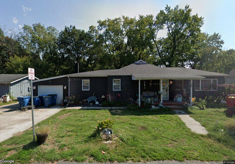
737 Central Ave Collinsville, IL 62234
Estimated Value: $139,000 - $189,356
4
Beds
1
Bath
1,878
Sq Ft
$88/Sq Ft
Est. Value
About This Home
This home is located at 737 Central Ave, Collinsville, IL 62234 and is currently estimated at $164,839, approximately $87 per square foot. 737 Central Ave is a home located in Madison County with nearby schools including Webster Elementary School, Dorris Intermediate School, and Collinsville Middle School.
Ownership History
Date
Name
Owned For
Owner Type
Purchase Details
Closed on
Feb 13, 2019
Sold by
Perucca Peter J
Bought by
Atwood Tim and Atwood Crystal
Current Estimated Value
Home Financials for this Owner
Home Financials are based on the most recent Mortgage that was taken out on this home.
Original Mortgage
$77,900
Outstanding Balance
$49,890
Interest Rate
4.4%
Mortgage Type
New Conventional
Estimated Equity
$114,949
Purchase Details
Closed on
Jun 6, 2014
Sold by
Perucca Peter J
Bought by
Perucca Peter J
Purchase Details
Closed on
Jul 7, 2008
Sold by
Mcconnell Henry L and Mcconnell Joanie L
Bought by
City Of Collinsville
Create a Home Valuation Report for This Property
The Home Valuation Report is an in-depth analysis detailing your home's value as well as a comparison with similar homes in the area
Home Values in the Area
Average Home Value in this Area
Purchase History
| Date | Buyer | Sale Price | Title Company |
|---|---|---|---|
| Atwood Tim | $82,000 | Abstracts & Titles | |
| Perucca Peter J | -- | None Available | |
| City Of Collinsville | $3,609 | None Available |
Source: Public Records
Mortgage History
| Date | Status | Borrower | Loan Amount |
|---|---|---|---|
| Open | Atwood Tim | $77,900 |
Source: Public Records
Tax History Compared to Growth
Tax History
| Year | Tax Paid | Tax Assessment Tax Assessment Total Assessment is a certain percentage of the fair market value that is determined by local assessors to be the total taxable value of land and additions on the property. | Land | Improvement |
|---|---|---|---|---|
| 2024 | $3,186 | $55,830 | $8,620 | $47,210 |
| 2023 | $3,186 | $51,680 | $7,980 | $43,700 |
| 2022 | $3,006 | $46,540 | $7,140 | $39,400 |
| 2021 | $2,606 | $43,730 | $6,710 | $37,020 |
| 2020 | $2,493 | $41,720 | $6,400 | $35,320 |
| 2019 | $2,413 | $40,290 | $6,180 | $34,110 |
| 2018 | $2,475 | $39,960 | $5,850 | $34,110 |
| 2017 | $2,470 | $39,160 | $5,730 | $33,430 |
| 2016 | $2,591 | $39,160 | $5,730 | $33,430 |
| 2015 | $2,406 | $38,140 | $5,580 | $32,560 |
| 2014 | $2,406 | $38,140 | $5,580 | $32,560 |
| 2013 | $2,406 | $38,140 | $5,580 | $32,560 |
Source: Public Records
Map
Nearby Homes
- 919 Vine St
- 921 Prospect St
- 501 Spring
- 238 Mill St
- 1210 Constance St
- 308 Brown Ave
- 617 N Morrison Ave
- 1120 Williams St
- 404 E Church St
- 216 S Chestnut St
- 123 W Wickliffe Ave
- 110 E Church St
- 1227 Ridge Ave
- 0 Strong Ave
- 892 Lester Ave
- 706 Illinois Ave
- 1224 Cedar Ridge Ct
- 580 N Guernsey St
- 121 S Seminary St
- 419 Bell St