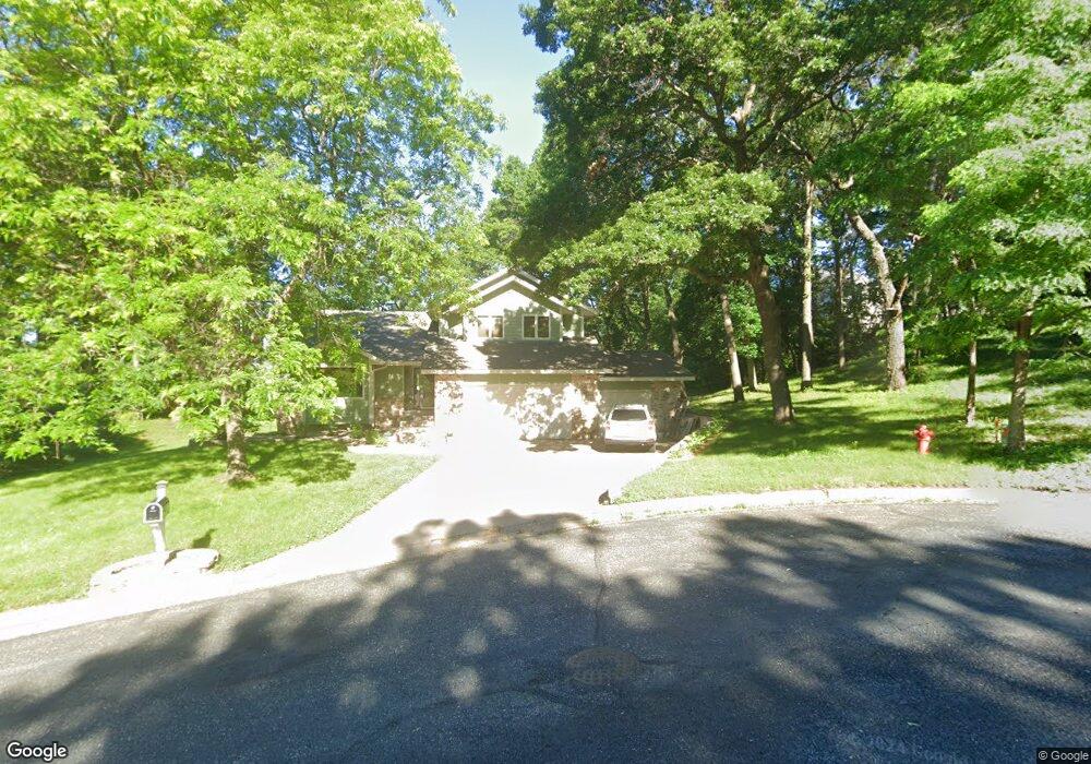
737 Deer Path Rd Hudson, WI 54016
Estimated Value: $436,000 - $531,000
3
Beds
3
Baths
--
Sq Ft
0.46
Acres
About This Home
This home is located at 737 Deer Path Rd, Hudson, WI 54016 and is currently estimated at $481,808. 737 Deer Path Rd is a home located in St. Croix County with nearby schools including North Hudson Elementary School, Hudson Middle School, and Hudson High School.
Ownership History
Date
Name
Owned For
Owner Type
Purchase Details
Closed on
Jul 9, 2019
Sold by
Gray Steve and Gray Kristen
Bought by
England Victor J and England Alexandra A
Current Estimated Value
Home Financials for this Owner
Home Financials are based on the most recent Mortgage that was taken out on this home.
Original Mortgage
$330,505
Outstanding Balance
$285,851
Interest Rate
3.73%
Mortgage Type
New Conventional
Estimated Equity
$195,957
Purchase Details
Closed on
Apr 5, 2018
Sold by
Gross Lori L and Gross Timothy
Bought by
Gray Steve and Gray Kristen
Home Financials for this Owner
Home Financials are based on the most recent Mortgage that was taken out on this home.
Original Mortgage
$248,000
Interest Rate
4.4%
Mortgage Type
New Conventional
Create a Home Valuation Report for This Property
The Home Valuation Report is an in-depth analysis detailing your home's value as well as a comparison with similar homes in the area
Home Values in the Area
Average Home Value in this Area
Purchase History
| Date | Buyer | Sale Price | Title Company |
|---|---|---|---|
| England Victor J | $347,900 | None Available | |
| Gray Steve | $310,000 | Partners Title |
Source: Public Records
Mortgage History
| Date | Status | Borrower | Loan Amount |
|---|---|---|---|
| Open | England Victor J | $330,505 | |
| Previous Owner | Gray Steve | $248,000 |
Source: Public Records
Tax History
| Year | Tax Paid | Tax Assessment Tax Assessment Total Assessment is a certain percentage of the fair market value that is determined by local assessors to be the total taxable value of land and additions on the property. | Land | Improvement |
|---|---|---|---|---|
| 2025 | $5,992 | $439,300 | $76,400 | $362,900 |
| 2024 | $53 | $408,800 | $76,400 | $332,400 |
| 2023 | $5,047 | $408,800 | $76,400 | $332,400 |
| 2022 | $5,715 | $408,800 | $76,400 | $332,400 |
| 2021 | $5,614 | $282,900 | $62,600 | $220,300 |
| 2020 | $5,414 | $282,900 | $62,600 | $220,300 |
| 2019 | $5,059 | $282,900 | $62,600 | $220,300 |
| 2018 | $5,034 | $282,900 | $62,600 | $220,300 |
| 2017 | $4,845 | $282,900 | $62,600 | $220,300 |
| 2016 | $4,845 | $282,900 | $62,600 | $220,300 |
| 2015 | $4,458 | $282,900 | $62,600 | $220,300 |
| 2014 | $4,420 | $282,900 | $62,600 | $220,300 |
| 2013 | $4,444 | $287,400 | $80,100 | $207,300 |
Source: Public Records
Map
Nearby Homes
- 1029 Sommers St N
- 1031 Sommers St N
- 1102 Sommers St N
- 602 Prairie Dr N
- 1143 Sommers St N
- 641 8th St N
- 811 Fox Tree Ln N
- 241 Starrwood
- 214 Galahad Place N
- 888 Bluebird Ct N
- 312 Meadow Dr N
- 1205 Riverside Dr N
- 1054 Cottonwood Dr
- 1205 Riverside Drive N
- 322 5th St N
- 1075 Autumn Oak Ln
- 312 3rd St N
- 621 Mallalieu Dr
- 233 River Heights Trail
- 1233 7th St
- 733 Deer Path Rd
- 733 Deer Path Rd N
- 738 Deer Path Rd
- 730 Woodcrest Dr N
- 734 Woodcrest Dr N
- 741 Summit Ln N
- 724 Woodcrest Dr N
- 742 Summit Ln N
- 729 Deer Path Rd
- 745 Summit Ln N
- 734 Deer Path Rd
- 729 Deer Path Rd
- 720 Woodcrest Dr N
- 749 Summit Ln N
- 723 Deer Path Rd
- 726 Deer Path Rd
- 735 Woodcrest Dr N
- 731 Woodcrest Dr N
- 712 Woodcrest Dr N
- 727 Woodcrest Dr N
Your Personal Tour Guide
Ask me questions while you tour the home.