


737 E Briar Ln Beloit, WI 53511
Estimated payment $1,348/month
Highlights
- Deck
- Main Floor Bedroom
- Gazebo
- Wood Flooring
- Sun or Florida Room
- Detached Garage
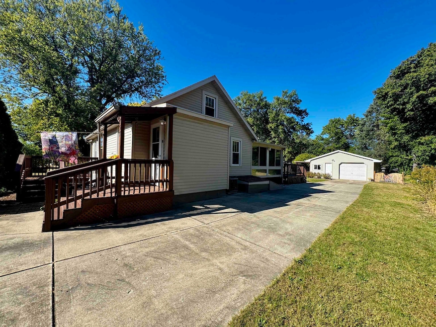
About This Home
Affordable and move-in ready, schedule a showing for this charming property! Well-maintained and featuring main floor living. This home has cozy vibes inside featuring hardwood floors, walk-in pantry, spacious en-suite bath with main floor laundry. The lovely sunroom has floor to ceiling windows with views to the great yard; or overlook the large backyard and beautiful gardens from your choice of the new deck or the gazebo. The drive-through garage is extra deep making it easy to store lawn equipment or toys. Turner school district. Call/Text Kassi Dixon at 608-201-4606
Listing Agent
Briggs Realty Group, Inc Brokerage Phone: 608-201-4606 License #88389-94 Listed on: 10/09/2025
Home Details
Home Type
- Single Family
Est. Annual Taxes
- $2,387
Year Built
- Built in 1935
Lot Details
- 0.36 Acre Lot
- Level Lot
Home Design
- Bungalow
- Vinyl Siding
Interior Spaces
- 1,297 Sq Ft Home
- 1.5-Story Property
- Sun or Florida Room
- Wood Flooring
- Basement Fills Entire Space Under The House
- Oven or Range
Bedrooms and Bathrooms
- 2 Bedrooms
- Main Floor Bedroom
- 1 Full Bathroom
- Bathroom on Main Level
- Walk-in Shower
Laundry
- Laundry Room
- Laundry on main level
- Dryer
- Washer
Parking
- Detached Garage
- Extra Deep Garage
- Garage Door Opener
- Driveway Level
Accessible Home Design
- Low Pile Carpeting
Outdoor Features
- Deck
- Gazebo
- Outdoor Storage
- Storage Shed
Schools
- Powers/Garden Prairie Elementary School
- Turner Middle School
- Turner High School
Utilities
- Forced Air Heating and Cooling System
- High Speed Internet
- Internet Available
- Cable TV Available
Map
Home Values in the Area
Average Home Value in this Area
Tax History
| Year | Tax Paid | Tax Assessment Tax Assessment Total Assessment is a certain percentage of the fair market value that is determined by local assessors to be the total taxable value of land and additions on the property. | Land | Improvement |
|---|---|---|---|---|
| 2025 | $2,382 | $143,500 | $14,100 | $129,400 |
| 2024 | $2,088 | $143,500 | $14,100 | $129,400 |
| 2023 | $1,978 | $143,500 | $14,100 | $129,400 |
| 2022 | $1,834 | $91,100 | $11,800 | $79,300 |
| 2020 | $1,917 | $91,100 | $11,800 | $79,300 |
| 2019 | $1,862 | $91,100 | $11,800 | $79,300 |
| 2018 | $1,732 | $77,800 | $11,800 | $66,000 |
| 2017 | $1,715 | $77,800 | $11,800 | $66,000 |
| 2016 | $1,914 | $77,800 | $11,800 | $66,000 |
| 2015 | $1,703 | $77,800 | $11,800 | $66,000 |
| 2014 | $1,730 | $77,800 | $11,800 | $66,000 |
| 2013 | $1,730 | $77,800 | $11,800 | $66,000 |
Property History
| Date | Event | Price | List to Sale | Price per Sq Ft |
|---|---|---|---|---|
| 11/29/2025 11/29/25 | Price Changed | $219,900 | -2.2% | $170 / Sq Ft |
| 10/09/2025 10/09/25 | For Sale | $224,900 | -- | $173 / Sq Ft |
Source: South Central Wisconsin Multiple Listing Service
MLS Number: 2010436
APN: 004 083013
Disclaimer: Certain information contained herein is derived from information provided by parties other than Homes.com. All information provided is deemed reliable, but is not guaranteed to be accurate and should be independently verified.
![]() IDX information is provided exclusively for personal, non-commercial use, and may not be used for any purpose other than to identify prospective properties consumers may be interested in purchasing. Information is deemed reliable but not guaranteed.
IDX information is provided exclusively for personal, non-commercial use, and may not be used for any purpose other than to identify prospective properties consumers may be interested in purchasing. Information is deemed reliable but not guaranteed.
- 2432 Wood Dr
- 2640 Shady Ln
- 2655 Jerry Thomas Pkwy Unit B
- 2635 Edgewood Dr Unit 63
- 2528 Edgewood Dr
- 871 E Cranston Rd
- 814 E Club Ln
- 1833 E Kyle Cir
- 2241 Tallgrass Ct Unit 12
- 2166 Bradley St
- 1726 Kyle Ln
- 1702 Kyle Ln
- 1708 Kyle Ln
- 1975 Pioneer Dr
- 2030 Gorton St
- 1739 E Kyle Cir
- 1815 E Kyle Cir
- 2230 S Riverside Dr
- 1551 Bayliss Ave
- 3150 S Bartells Dr Unit A
- 2600 Kadlec Dr
- 2770 Iva Ct
- 2760 Kadlec Dr
- 1854-1856 Northgate Dr
- 2900 S Gray Bill Dr Unit 102
- 2900 S Gray Bill Dr Unit 103
- 2913 S Park Ave
- 1619-1635 E Inman Pkwy
- 0 Kyle Ln Unit 1832 W. Kyle Cir
- 2532 N Bootmaker Dr
- 2361 E Ridge Rd
- 1310 Copeland Ave
- 2431 Blarney Stone Dr
- 1800 6th St
- 1349 Yates Ave
- 2101 Freeman Pkwy
- 1271 Prairie Ave Unit 1271
- 420 Ridgeland Ave
- 1035 Pleasant St
- 920 Park Ave
