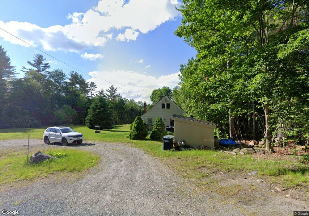
737 Maple St Bethlehem, NH 03574
Estimated Value: $290,000 - $353,000
3
Beds
1
Bath
1,053
Sq Ft
$300/Sq Ft
Est. Value
About This Home
This home is located at 737 Maple St, Bethlehem, NH 03574 and is currently estimated at $316,259, approximately $300 per square foot. 737 Maple St is a home located in Grafton County with nearby schools including Bethlehem Elementary School, Profile Junior High School, and Profile Senior High School.
Ownership History
Date
Name
Owned For
Owner Type
Purchase Details
Closed on
Nov 3, 2008
Sold by
Murphy Stephen J
Bought by
Sjm Re Llc
Current Estimated Value
Purchase Details
Closed on
Feb 3, 2006
Sold by
Wright Andrew
Bought by
Murphy Stephen
Home Financials for this Owner
Home Financials are based on the most recent Mortgage that was taken out on this home.
Original Mortgage
$55,250
Interest Rate
6.31%
Mortgage Type
Purchase Money Mortgage
Create a Home Valuation Report for This Property
The Home Valuation Report is an in-depth analysis detailing your home's value as well as a comparison with similar homes in the area
Home Values in the Area
Average Home Value in this Area
Purchase History
| Date | Buyer | Sale Price | Title Company |
|---|---|---|---|
| Sjm Re Llc | $108,000 | -- | |
| Murphy Stephen | $96,000 | -- |
Source: Public Records
Mortgage History
| Date | Status | Borrower | Loan Amount |
|---|---|---|---|
| Previous Owner | Murphy Stephen | $55,250 |
Source: Public Records
Tax History
| Year | Tax Paid | Tax Assessment Tax Assessment Total Assessment is a certain percentage of the fair market value that is determined by local assessors to be the total taxable value of land and additions on the property. | Land | Improvement |
|---|---|---|---|---|
| 2024 | $4,005 | $233,100 | $51,400 | $181,700 |
| 2023 | $3,597 | $233,100 | $51,400 | $181,700 |
| 2022 | $3,125 | $130,800 | $24,200 | $106,600 |
| 2021 | $3,243 | $130,800 | $24,200 | $106,600 |
| 2020 | $3,296 | $130,800 | $24,200 | $106,600 |
| 2019 | $2,437 | $130,800 | $24,200 | $106,600 |
| 2018 | $3,309 | $130,800 | $24,200 | $106,600 |
| 2017 | $3,143 | $102,300 | $28,100 | $74,200 |
| 2016 | $2,809 | $102,300 | $28,100 | $74,200 |
| 2015 | $3,030 | $102,300 | $28,100 | $74,200 |
| 2013 | $2,921 | $102,300 | $28,100 | $74,200 |
Source: Public Records
Map
Nearby Homes
- 731 Maple St
- 787 Maple St
- 829 Maple St
- 5 Longfellow Dr Unit 5
- 7 Longfellow Dr Unit 5
- 849 Maple St
- 00 Arrowhead Unit 2
- 852 Maple St
- 467 Longfellow Dr Unit 67
- 468 Longfellow Dr Unit 68
- 468 Longfellow Dr
- 466 Longfellow Dr Unit 66
- 32 Longfellow Dr
- 871 Maple St
- 463 Longfellow Dr Unit 63
- 27 Longfellow Dr
- 27 Longfellow Dr Unit 27
- 344 Longfellow Dr Unit 34
- 344 Longfellow Dr Unit 44
Your Personal Tour Guide
Ask me questions while you tour the home.