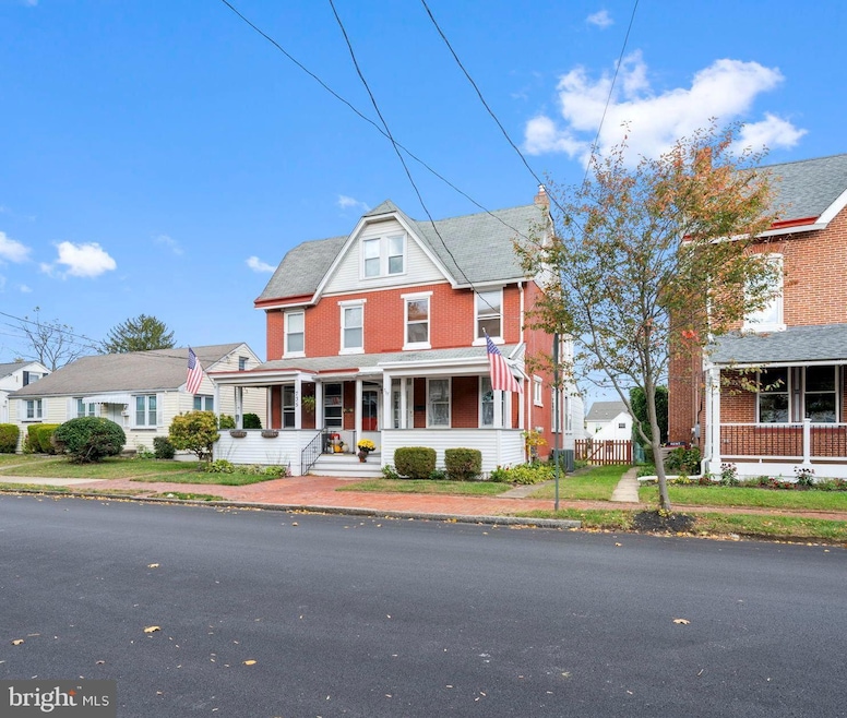


737 S Matlack St West Chester, PA 19382
Estimated payment $3,006/month
Highlights
- Colonial Architecture
- No HOA
- 2 Car Detached Garage
- Westtown-Thornbury Elementary School Rated A
- Breakfast Area or Nook
- Chair Railings
About This Home
Welcome to 737 S. Matlack Street, a beautifully restored twin in the highly sought-after West Chester Borough, just a short walk to the shops, restaurants, and charm of downtown. From the moment you arrive, the inviting covered front porch sets the tone for this classic yet modern home. Step inside to find original hardwood floors that have been beautifully refinished in a rich dark walnut stain, flowing seamlessly throughout the entire house. The home has been completely repainted and showcases extravagant light fixtures that complement its perfect blend of modern style and vintage character. The main level features bright, open living and dining spaces leading into the kitchen with brand new appliances, offering both function and charm. Both bathrooms have been thoughtfully restored, maintaining the home’s original character while providing a fresh, elegant feel. Upstairs, the 2nd floor's 3 spacious bedrooms include the primary bedroom with custom built-in closets for added organization and luxury. The third floor has been fully refinished and serves as a versatile fourth bedroom, guest suite, or home office. The walkout basement offers plenty of room for storage. Central Air! Outside, enjoy a private fenced-in backyard ideal for entertaining or relaxing, along with a spacious shed, and detached two-car garage accessible from the rear alley. The garage features electric service and a full loft, offering endless possibilities for storage, a workshop, or creative space. This rare Borough gem combines timeless character with modern updates in one of the most desirable locations in Chester County, Pennsylvania. Just park the car, walk to town, and enjoy the best of Borough living.
Listing Agent
(484) 888-3177 deneen@cipranisweeney.com Keller Williams Real Estate - West Chester License #RS-0023053 Listed on: 10/24/2025

Co-Listing Agent
(484) 467-5206 shawn@fetickteam.com Keller Williams Real Estate - West Chester
Townhouse Details
Home Type
- Townhome
Est. Annual Taxes
- $4,532
Year Built
- Built in 1900
Lot Details
- 5,227 Sq Ft Lot
- Chain Link Fence
Parking
- 2 Car Detached Garage
- Parking Storage or Cabinetry
- Free Parking
- Rear-Facing Garage
- Gravel Driveway
- On-Street Parking
Home Design
- Semi-Detached or Twin Home
- Colonial Architecture
- Brick Exterior Construction
- Brick Foundation
- Stone Foundation
- Chimney Cap
Interior Spaces
- 1,656 Sq Ft Home
- Property has 3 Levels
- Built-In Features
- Chair Railings
- Ceiling Fan
- Dining Area
- Laundry on main level
Kitchen
- Breakfast Area or Nook
- Eat-In Kitchen
- Electric Oven or Range
- Stove
- Cooktop with Range Hood
- Ice Maker
- Dishwasher
Bedrooms and Bathrooms
- 4 Bedrooms
- Walk-in Shower
Unfinished Basement
- Walk-Out Basement
- Basement Fills Entire Space Under The House
- Basement Windows
Outdoor Features
- Exterior Lighting
- Shed
- Outbuilding
- Rain Gutters
Utilities
- Forced Air Heating and Cooling System
- Heating System Uses Oil
- Electric Water Heater
Community Details
- No Home Owners Association
Listing and Financial Details
- Tax Lot 0043
- Assessor Parcel Number 01-13 -0043
Map
Home Values in the Area
Average Home Value in this Area
Tax History
| Year | Tax Paid | Tax Assessment Tax Assessment Total Assessment is a certain percentage of the fair market value that is determined by local assessors to be the total taxable value of land and additions on the property. | Land | Improvement |
|---|---|---|---|---|
| 2025 | $4,339 | $123,690 | $43,190 | $80,500 |
| 2024 | $4,339 | $123,690 | $43,190 | $80,500 |
| 2023 | $4,290 | $123,690 | $43,190 | $80,500 |
| 2022 | $4,244 | $123,690 | $43,190 | $80,500 |
| 2021 | $4,158 | $123,690 | $43,190 | $80,500 |
| 2020 | $4,081 | $123,690 | $43,190 | $80,500 |
| 2019 | $4,032 | $123,690 | $43,190 | $80,500 |
| 2018 | $3,960 | $123,690 | $43,190 | $80,500 |
| 2017 | $3,887 | $123,690 | $43,190 | $80,500 |
| 2016 | $2,622 | $123,690 | $43,190 | $80,500 |
| 2015 | $2,622 | $123,690 | $43,190 | $80,500 |
| 2014 | $2,622 | $123,690 | $43,190 | $80,500 |
Property History
| Date | Event | Price | List to Sale | Price per Sq Ft |
|---|---|---|---|---|
| 10/24/2025 10/24/25 | For Sale | $499,000 | -- | $301 / Sq Ft |
Purchase History
| Date | Type | Sale Price | Title Company |
|---|---|---|---|
| Deed | $367,000 | Partners Settlements & Escrow |
Mortgage History
| Date | Status | Loan Amount | Loan Type |
|---|---|---|---|
| Open | $293,600 | New Conventional |
Source: Bright MLS
MLS Number: PACT2112164
APN: 01-013-0043.0000
Disclaimer: Certain information contained herein is derived from information provided by parties other than Homes.com. All information provided is deemed reliable, but is not guaranteed to be accurate and should be independently verified.
![]() The data relating to real estate for sale on this website appears in part through the BRIGHT Internet Data Exchange program, a voluntary cooperative exchange of property listing data between licensed real estate brokerage firms, and is provided by BRIGHT through a licensing agreement.
The data relating to real estate for sale on this website appears in part through the BRIGHT Internet Data Exchange program, a voluntary cooperative exchange of property listing data between licensed real estate brokerage firms, and is provided by BRIGHT through a licensing agreement.
Listing information is from various brokers who participate in the Bright MLS IDX program and not all listings may be visible on the site.
The property information being provided on or through the website is for the personal, non-commercial use of consumers and such information may not be used for any purpose other than to identify prospective properties consumers may be interested in purchasing.
Some properties which appear for sale on the website may no longer be available because they are for instance, under contract, sold or are no longer being offered for sale.
Property information displayed is deemed reliable but is not guaranteed.
Copyright 2025 Bright MLS, Inc.
- 749 S Matlack St
- 738 S Matlack St
- 615 S Walnut St
- 615-617 S Walnut St
- 335 S Adams St
- 305 S Matlack St
- 305 S Walnut St
- 116 Price St
- 113 Peabody Way
- 408 S Church St
- 342 E Barnard St
- 344 E Barnard St
- 110 S Matlack St
- 145 E Miner St
- 113 E Miner St
- 714 S Wayne St
- 238 E Gay St Unit 2
- 5 Yorktown Ave
- 852 Cedar Ave
- 331 Hannum Ave
- 739 S Matlack St
- 742 S Matlack St
- 133 E Nields St
- 537 S Walnut St
- 301 S Matlack St Unit A - 1st Floor
- 301 S Matlack St Unit A - 1st Floor
- 164 Justin Dr
- 305 S Walnut St Unit 3
- 131 E Union St
- 122 Price St
- 122 Price St
- 310 E Barnard St
- 342 E Barnard St
- 113 Dean St Unit 2
- 123 S Matlack St
- 308 S Church St Unit 4
- 124 E Market St
- 890 S Matlack St
- 238 E Gay St
- 326 Dean St