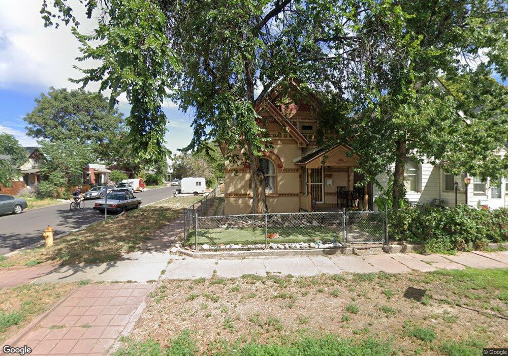
737 W 1st Ave Denver, CO 80223
Baker NeighborhoodEstimated Value: $478,318 - $559,000
2
Beds
1
Bath
--
Sq Ft
2,483
Sq Ft Lot
About This Home
This home is located at 737 W 1st Ave, Denver, CO 80223 and is currently estimated at $505,330. 737 W 1st Ave is a home located in Denver County with nearby schools including Kepner Beacon Middle School, West High School, and Girls Athletic Leadership School.
Ownership History
Date
Name
Owned For
Owner Type
Purchase Details
Closed on
Aug 16, 2019
Sold by
The Dale Rolland Andrus Trust
Bought by
Andrus Michael Dale
Current Estimated Value
Purchase Details
Closed on
Jul 29, 2013
Sold by
Andrus Anne Marie
Bought by
Dale Rolland Andrus Trust
Purchase Details
Closed on
May 25, 2010
Sold by
Andrus Dale Rolland
Bought by
Andrus Michael Dale
Purchase Details
Closed on
Nov 12, 1999
Sold by
Andrus Dale R
Bought by
Thompson Daniel
Create a Home Valuation Report for This Property
The Home Valuation Report is an in-depth analysis detailing your home's value as well as a comparison with similar homes in the area
Home Values in the Area
Average Home Value in this Area
Purchase History
| Date | Buyer | Sale Price | Title Company |
|---|---|---|---|
| Andrus Michael Dale | -- | None Available | |
| Dale Rolland Andrus Trust | -- | None Available | |
| Andrus Michael Dale | -- | None Available | |
| Andrus Dale Rolland | -- | None Available | |
| Thompson Daniel | $293,000 | Land Title |
Source: Public Records
Tax History Compared to Growth
Tax History
| Year | Tax Paid | Tax Assessment Tax Assessment Total Assessment is a certain percentage of the fair market value that is determined by local assessors to be the total taxable value of land and additions on the property. | Land | Improvement |
|---|---|---|---|---|
| 2024 | $2,295 | $28,970 | $12,360 | $16,610 |
| 2023 | $2,245 | $28,970 | $12,360 | $16,610 |
| 2022 | $2,236 | $28,120 | $14,150 | $13,970 |
| 2021 | $2,159 | $28,930 | $14,560 | $14,370 |
| 2020 | $1,997 | $26,920 | $9,850 | $17,070 |
| 2019 | $1,941 | $26,920 | $9,850 | $17,070 |
| 2018 | $1,680 | $21,720 | $7,330 | $14,390 |
| 2017 | $1,675 | $21,720 | $7,330 | $14,390 |
| 2016 | $1,552 | $19,030 | $6,193 | $12,837 |
| 2015 | $1,487 | $19,030 | $6,193 | $12,837 |
| 2014 | $1,163 | $14,000 | $1,775 | $12,225 |
Source: Public Records
Map
Nearby Homes
- 45 Galapago St
- 48 Galapago St
- 314 Galapago St
- 323 Inca St
- 321 Fox St
- 351 Santa fe Dr
- 7 Elati St
- 510 W 4th Ave
- 274 Delaware St
- 333 Delaware St
- 421 Elati St
- 475 Galapago St Unit 3
- 469 Elati St
- 256 Bannock St
- 314 W 5th Ave
- 1489 W Cedar Ave
- 115 W 2nd Ave Unit 105
- 145 S Cherokee St
- 160 W Bayaud Ave
- 722 W 6th Ave