M
Seller's Agent in 2025
Myron Miller
Kaufman Realty & Auction, LLC.
(330) 204-0864
22 Total Sales
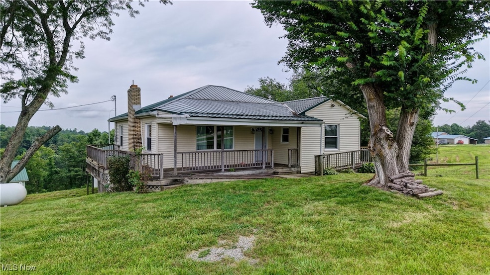
Don't miss this beautifully updated 2 bedroom, 1 bath home situated on 5.3 picturesque acres just minutes from scenic Piedmont Lake. Recently remodeled main floor features all new cabinetry, flooring, and appliances-all included in the sale. Enjoy plenty of storage and workspace with a 2 car garage plus an additional attached garage perfect for your boat or recreational vehicles. The property also features a barn with 4 tie stalls and 2 box stalls plus a fenced pasture ideal for livestock, a well-maintained barn, and a wooded area perfect for hunting or outdoor recreation. Whether you're looking for a peaceful country retreat or a ready-to-go hobby farm, this property has it all - space, privacy, and modern updates. Just west of Piedmont Marina. Agent is owner. Schedule your showing today!
Last Agent to Sell the Property
Kaufman Realty & Auction, LLC. Brokerage Email: myron.miller@kaufmanrealty.com, 330-204-0864 License #2019005760 Listed on: 07/18/2025
Co-Listed By
Kaufman Realty & Auction, LLC. Brokerage Email: myron.miller@kaufmanrealty.com, 330-204-0864 License #433804
| Date | Type | Sale Price | Title Company |
|---|---|---|---|
| Deed | $200,000 | None Listed On Document | |
| Warranty Deed | $121,000 | None Listed On Document | |
| Warranty Deed | $121,000 | None Listed On Document | |
| Warranty Deed | $175,000 | None Listed On Document | |
| Survivorship Deed | $100,000 | Secure Title Agency | |
| Warranty Deed | $70,000 | None Available |
| Date | Status | Loan Amount | Loan Type |
|---|---|---|---|
| Open | $196,377 | FHA | |
| Previous Owner | $92,197 | Purchase Money Mortgage |
| Date | Event | Price | List to Sale | Price per Sq Ft |
|---|---|---|---|---|
| 09/30/2025 09/30/25 | Sold | $200,000 | -8.7% | $164 / Sq Ft |
| 08/21/2025 08/21/25 | Pending | -- | -- | -- |
| 07/29/2025 07/29/25 | Price Changed | $219,000 | -2.7% | $180 / Sq Ft |
| 07/18/2025 07/18/25 | For Sale | $225,000 | -- | $184 / Sq Ft |
| Year | Tax Paid | Tax Assessment Tax Assessment Total Assessment is a certain percentage of the fair market value that is determined by local assessors to be the total taxable value of land and additions on the property. | Land | Improvement |
|---|---|---|---|---|
| 2025 | $1,835 | $47,060 | $14,871 | $32,189 |
| 2024 | $1,837 | $47,060 | $14,871 | $32,189 |
| 2023 | $1,776 | $38,576 | $12,190 | $26,386 |
| 2022 | $1,542 | $38,570 | $12,190 | $26,380 |
| 2021 | $1,485 | $38,570 | $12,190 | $26,380 |
| 2020 | $1,338 | $35,120 | $10,490 | $24,630 |
| 2019 | $1,325 | $35,120 | $10,490 | $24,630 |
| 2018 | $1,303 | $35,120 | $10,490 | $24,630 |
| 2017 | $1,238 | $30,460 | $9,120 | $21,340 |
| 2016 | $1,220 | $30,460 | $9,120 | $21,340 |
| 2015 | $1,220 | $30,460 | $9,120 | $21,340 |
| 2014 | -- | $27,610 | $6,470 | $21,140 |
| 2013 | $1,139 | $27,610 | $6,470 | $21,140 |
M
Seller's Agent in 2025
Myron Miller
Kaufman Realty & Auction, LLC.
(330) 204-0864
22 Total Sales

Seller Co-Listing Agent in 2025
Steven Maag
Kaufman Realty & Auction, LLC.
(330) 763-4769
77 Total Sales
Buyer's Agent in 2025
Jennifer Meek
Barnett Inc. Realtors
(330) 204-4718
52 Total Sales
Source: MLS Now
MLS Number: 5141117
APN: 20-0000506.000
Disclaimer: Certain information contained herein is derived from information provided by parties other than Homes.com. All information provided is deemed reliable, but is not guaranteed to be accurate and should be independently verified.
![]() IDX information is provided exclusively for personal, non-commercial use, and may not be used for any purpose other than to identify prospective properties consumers may be interested in purchasing. Information is deemed reliable but not guaranteed.
IDX information is provided exclusively for personal, non-commercial use, and may not be used for any purpose other than to identify prospective properties consumers may be interested in purchasing. Information is deemed reliable but not guaranteed.
Ask me questions while you tour the home.