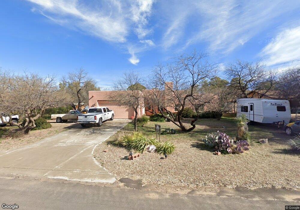
739 N John Adams St Oracle, AZ 85623
Estimated Value: $372,000 - $454,000
3
Beds
2
Baths
1,732
Sq Ft
$232/Sq Ft
Est. Value
About This Home
This home is located at 739 N John Adams St, Oracle, AZ 85623 and is currently estimated at $402,591, approximately $232 per square foot. 739 N John Adams St is a home located in Pinal County with nearby schools including Mountain Vista School.
Ownership History
Date
Name
Owned For
Owner Type
Purchase Details
Closed on
Nov 5, 2009
Sold by
Capone Carol
Bought by
Amado Richard P and Amado Rosalia G
Current Estimated Value
Home Financials for this Owner
Home Financials are based on the most recent Mortgage that was taken out on this home.
Original Mortgage
$203,250
Outstanding Balance
$132,782
Interest Rate
5.01%
Mortgage Type
FHA
Estimated Equity
$269,809
Purchase Details
Closed on
Jan 11, 2005
Sold by
Pfaff Donald L and Pfaff Toni S
Bought by
Capone Carol
Purchase Details
Closed on
Jun 14, 2004
Sold by
Miller Cyrus H and Miller Sue
Bought by
Pfaff Donald L and Praff Toni S
Home Financials for this Owner
Home Financials are based on the most recent Mortgage that was taken out on this home.
Original Mortgage
$22,400
Interest Rate
6.09%
Mortgage Type
Seller Take Back
Create a Home Valuation Report for This Property
The Home Valuation Report is an in-depth analysis detailing your home's value as well as a comparison with similar homes in the area
Home Values in the Area
Average Home Value in this Area
Purchase History
| Date | Buyer | Sale Price | Title Company |
|---|---|---|---|
| Amado Richard P | $207,000 | Title Security Agency Of Ari | |
| Capone Carol | $193,619 | Lawyers Title Ins | |
| Pfaff Donald L | $28,000 | First Financial Title Agency |
Source: Public Records
Mortgage History
| Date | Status | Borrower | Loan Amount |
|---|---|---|---|
| Open | Amado Richard P | $203,250 | |
| Previous Owner | Pfaff Donald L | $22,400 |
Source: Public Records
Tax History Compared to Growth
Tax History
| Year | Tax Paid | Tax Assessment Tax Assessment Total Assessment is a certain percentage of the fair market value that is determined by local assessors to be the total taxable value of land and additions on the property. | Land | Improvement |
|---|---|---|---|---|
| 2025 | $1,658 | $34,708 | -- | -- |
| 2024 | $1,535 | $37,500 | -- | -- |
| 2023 | $1,698 | $23,936 | $2,070 | $21,866 |
| 2022 | $1,535 | $19,436 | $2,070 | $17,366 |
| 2021 | $1,571 | $19,297 | $0 | $0 |
| 2020 | $1,541 | $17,609 | $0 | $0 |
| 2019 | $1,427 | $17,633 | $0 | $0 |
| 2018 | $1,370 | $17,039 | $0 | $0 |
| 2017 | $1,323 | $17,308 | $0 | $0 |
| 2016 | $1,280 | $17,521 | $2,806 | $14,715 |
| 2014 | -- | $9,532 | $1,897 | $7,636 |
Source: Public Records
Map
Nearby Homes
- 1074 N White Oak Place
- 978 N White Oak Place
- 760 E American Ave
- +/-1 acre E American Ave
- 1125 E Paseo Encino
- 881 N Mountain View Dr
- 1243 E Aldwinkle Place
- 0 E Mount Lemmon Hwy Unit 22516461
- TBD E Mount Lemmon Hwy Unit 8.36 Ac
- 2000 E Mount Lemmon Hwy
- 320 N Estill Dr
- TBD N Estill Dr Unit 9.54 AC
- TBD N Viento Dr Unit 1
- TBD N Callas Dr Unit 20 Ac
- 181 W Oak Hills Dr
- 853 N Stewart Dr
- 280 W Oak Hills Dr
- 117 S Hobe Rd
- 2.5 ac W Oak Hills Dr Unit A
- 325 W Oak Hills Dr
- 715 N John Adams St
- 785 N John Adams St
- 770 N Cody Loop Rd
- 730 N Cody Loop Rd
- 790 N Cody Loop Rd
- 685 N John Adams St
- 680 N Cody Loop Rd
- 760 N John Adams St
- 845 N John Adams St
- 710 N John Adams St
- 645 N John Adams St
- 640 N Cody Loop Rd
- 830 N Cody Loop Rd Unit 4
- 830 N Cody Loop Rd Unit 3
- 830 N Cody Loop Rd Unit 2
- 830 N Cody Loop Rd Unit 6
- 830 N Cody Loop Rd Unit 1
- 830 N Cody Loop Rd Unit 5
- 715 N Cody Loop Rd