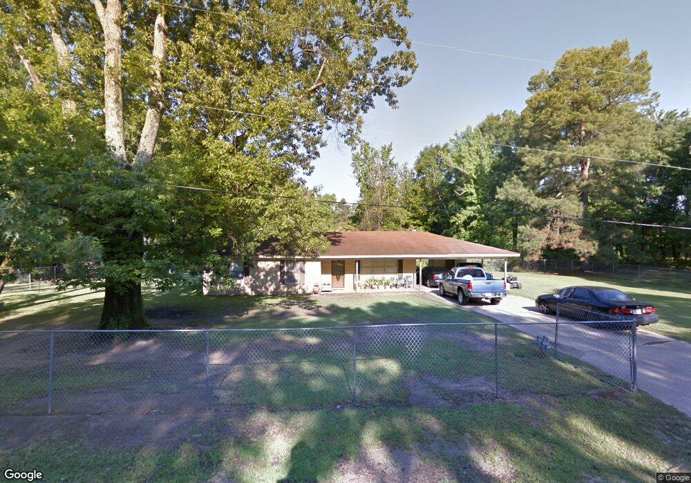
739 N Laney Rd Crossett, AR 71635
Estimated Value: $15,000 - $146,000
Studio
2
Baths
1,302
Sq Ft
$70/Sq Ft
Est. Value
About This Home
This home is located at 739 N Laney Rd, Crossett, AR 71635 and is currently estimated at $91,000, approximately $69 per square foot. 739 N Laney Rd is a home located in Ashley County with nearby schools including Crossett Elementary School, Crossett Middle School, and Crossett High School.
Ownership History
Date
Name
Owned For
Owner Type
Purchase Details
Closed on
Jul 25, 2025
Sold by
Commissioner Of State Lands
Bought by
Williams Dennis O
Current Estimated Value
Purchase Details
Closed on
Nov 29, 2010
Sold by
Miller Doyle Lee
Bought by
Williams Dennis O
Purchase Details
Closed on
Nov 22, 2010
Sold by
Miller Doyle Lee
Bought by
Williams Dennis O
Purchase Details
Closed on
Oct 5, 1995
Bought by
Miller Doyle Lee
Purchase Details
Closed on
Jul 6, 1979
Bought by
Miller Doyle Lee
Purchase Details
Closed on
Mar 7, 1979
Bought by
Wilson Willie Mae
Create a Home Valuation Report for This Property
The Home Valuation Report is an in-depth analysis detailing your home's value as well as a comparison with similar homes in the area
Home Values in the Area
Average Home Value in this Area
Purchase History
| Date | Buyer | Sale Price | Title Company |
|---|---|---|---|
| Williams Dennis O | $2,050 | None Listed On Document | |
| Williams Dennis O | -- | -- | |
| Williams Dennis O | -- | -- | |
| Miller Doyle Lee | -- | -- | |
| Miller Doyle Lee | -- | -- | |
| Wilson Willie Mae | -- | -- |
Source: Public Records
Tax History
| Year | Tax Paid | Tax Assessment Tax Assessment Total Assessment is a certain percentage of the fair market value that is determined by local assessors to be the total taxable value of land and additions on the property. | Land | Improvement |
|---|---|---|---|---|
| 2025 | $242 | $20,250 | $3,500 | $16,750 |
| 2024 | $305 | $20,250 | $3,500 | $16,750 |
| 2023 | $344 | $20,250 | $3,500 | $16,750 |
| 2022 | $527 | $15,490 | $3,600 | $11,890 |
| 2021 | $527 | $15,490 | $3,600 | $11,890 |
| 2020 | $519 | $15,490 | $3,600 | $11,890 |
| 2019 | $487 | $15,490 | $3,600 | $11,890 |
| 2018 | $481 | $15,490 | $3,600 | $11,890 |
| 2017 | $279 | $13,310 | $3,000 | $10,310 |
| 2016 | $576 | $13,310 | $3,000 | $10,310 |
| 2015 | $576 | $13,310 | $3,000 | $10,310 |
| 2014 | $576 | $13,310 | $3,000 | $10,310 |
Source: Public Records
Map
Nearby Homes
- TBD Tarver Rd
- 950 Hancock Rd
- 4313 Coronet St
- .64 acre N Texas St
- 308 N Mississippi St
- 502 N Tennessee St
- 501 N Tennessee St
- 506 N Carolina St
- 1700 S Tennessee St
- Lot 003 Tennessee St
- 809 S Kentucky St
- 000 Fairview Rd Hwy 133 N
- 700 W 13th Ave
- 1708 Parkway Dr
- 600 Patton Dr
- 402 Elm St
- 1436 Mimosa St
- 802 Elm St
- 103 Brentwood Cir
- 209 Stonegate Ct
- 740 N Laney Rd
- 744 N Laney Rd
- 0 First Ave Unit 18009462
- 0 First Ave Ave Unit 18009461
- x First
- 829 N Laney Rd
- 3504 W Laney Rd
- 3506 W Laney Rd
- 3202 W Laney Rd
- 738 Curtis Martin Rd
- 744 Curtis Martin Rd
- 3411 W Laney Rd
- 3601 W Laney Rd
- 811 N Taylor Carter Rd
- 730 Smith Nail Loop
- 617 N Laney Rd
- 745 Curtis Martin Rd
- 3129 Brown Rd
- 3700 W Laney Rd
- 727 Curtis Martin Rd
Your Personal Tour Guide
Ask me questions while you tour the home.