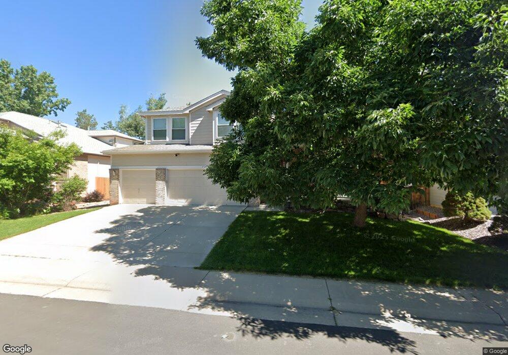
739 Peach Ct Louisville, CO 80027
Estimated Value: $1,019,000 - $1,225,000
3
Beds
3
Baths
2,520
Sq Ft
$443/Sq Ft
Est. Value
About This Home
This home is located at 739 Peach Ct, Louisville, CO 80027 and is currently estimated at $1,116,523, approximately $443 per square foot. 739 Peach Ct is a home located in Boulder County with nearby schools including Monarch K-8 School, Monarch High School, and The Goddard School - Louisville.
Ownership History
Date
Name
Owned For
Owner Type
Purchase Details
Closed on
Mar 13, 1998
Sold by
Sheffield Homes Coal Creek Llc
Bought by
Walters David L
Current Estimated Value
Home Financials for this Owner
Home Financials are based on the most recent Mortgage that was taken out on this home.
Original Mortgage
$200,000
Outstanding Balance
$36,944
Interest Rate
7.13%
Estimated Equity
$1,079,579
Purchase Details
Closed on
Feb 3, 1993
Bought by
Walters David L and Walters Rosalyn C
Create a Home Valuation Report for This Property
The Home Valuation Report is an in-depth analysis detailing your home's value as well as a comparison with similar homes in the area
Home Values in the Area
Average Home Value in this Area
Purchase History
| Date | Buyer | Sale Price | Title Company |
|---|---|---|---|
| Walters David L | $279,306 | Land Title | |
| Walters David L | -- | -- |
Source: Public Records
Mortgage History
| Date | Status | Borrower | Loan Amount |
|---|---|---|---|
| Open | Walters David L | $200,000 |
Source: Public Records
Tax History Compared to Growth
Tax History
| Year | Tax Paid | Tax Assessment Tax Assessment Total Assessment is a certain percentage of the fair market value that is determined by local assessors to be the total taxable value of land and additions on the property. | Land | Improvement |
|---|---|---|---|---|
| 2025 | $5,346 | $65,694 | $30,569 | $35,125 |
| 2024 | $5,346 | $65,694 | $30,569 | $35,125 |
| 2023 | $5,256 | $66,183 | $31,637 | $38,230 |
| 2022 | $4,269 | $51,312 | $22,956 | $28,356 |
| 2021 | $4,484 | $55,570 | $24,861 | $30,709 |
| 2020 | $3,997 | $49,864 | $21,736 | $28,128 |
| 2019 | $3,940 | $49,864 | $21,736 | $28,128 |
| 2018 | $3,604 | $47,542 | $13,968 | $33,574 |
| 2017 | $3,532 | $52,559 | $15,442 | $37,117 |
| 2016 | $3,231 | $44,679 | $15,442 | $29,237 |
| 2015 | $3,726 | $40,143 | $9,632 | $30,511 |
| 2014 | $3,432 | $40,143 | $9,632 | $30,511 |
Source: Public Records
Map
Nearby Homes
- 749 Apple Ct
- 546 Ridgeview Dr
- 362 S Taft Ct Unit 108
- 572 Ridgeview Dr
- 305 S Taft Ct Unit 33
- 323 S Taft Ct Unit 26
- 284 S Taft Ct Unit 76
- 620 Ridgeview Dr
- 279 S Taft Ct Unit 53
- 716 Club Cir
- 567 Manorwood Ln
- 730 Copper Ln Unit 106
- 539 Coal Creek Ln
- 641 W Dahlia St
- 499 Muirfield Cir
- 497 Muirfield Cir
- 203 Springs Dr
- 159 S Polk Ave
- 494 Muirfield Cir
- 118 S Tanager Ct