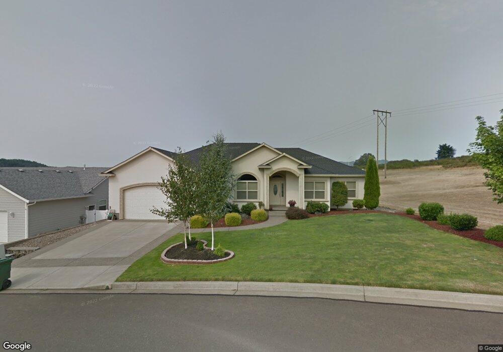
739 Sandpiper Ct Sutherlin, OR 97479
Estimated Value: $468,000 - $579,000
3
Beds
2
Baths
2,208
Sq Ft
$236/Sq Ft
Est. Value
About This Home
This home is located at 739 Sandpiper Ct, Sutherlin, OR 97479 and is currently estimated at $520,477, approximately $235 per square foot. 739 Sandpiper Ct is a home located in Douglas County with nearby schools including East Sutherlin Primary School, West Sutherlin Intermediate School, and Sutherlin Middle School.
Ownership History
Date
Name
Owned For
Owner Type
Purchase Details
Closed on
Jul 20, 2016
Sold by
Kuhlman Robert Walter and Kuhlman Jill
Bought by
Mooney Michael B and Mooney Sherilyn S
Current Estimated Value
Home Financials for this Owner
Home Financials are based on the most recent Mortgage that was taken out on this home.
Original Mortgage
$351,116
Outstanding Balance
$279,935
Interest Rate
3.54%
Mortgage Type
VA
Estimated Equity
$240,542
Purchase Details
Closed on
Nov 3, 2006
Sold by
Powell Todd C and Banducci Dick
Bought by
Kuhlman Robert W and Kuhlman Jill
Home Financials for this Owner
Home Financials are based on the most recent Mortgage that was taken out on this home.
Original Mortgage
$185,000
Interest Rate
6.28%
Mortgage Type
Purchase Money Mortgage
Create a Home Valuation Report for This Property
The Home Valuation Report is an in-depth analysis detailing your home's value as well as a comparison with similar homes in the area
Home Values in the Area
Average Home Value in this Area
Purchase History
| Date | Buyer | Sale Price | Title Company |
|---|---|---|---|
| Mooney Michael B | $339,900 | First American Title | |
| Kuhlman Robert W | $375,000 | First American Title Ins Co |
Source: Public Records
Mortgage History
| Date | Status | Borrower | Loan Amount |
|---|---|---|---|
| Open | Mooney Michael B | $351,116 | |
| Previous Owner | Kuhlman Robert W | $185,000 |
Source: Public Records
Tax History Compared to Growth
Tax History
| Year | Tax Paid | Tax Assessment Tax Assessment Total Assessment is a certain percentage of the fair market value that is determined by local assessors to be the total taxable value of land and additions on the property. | Land | Improvement |
|---|---|---|---|---|
| 2024 | $3,661 | $306,063 | -- | -- |
| 2023 | $3,556 | $297,149 | $0 | $0 |
| 2022 | $3,454 | $288,491 | $0 | $0 |
| 2021 | $3,355 | $280,087 | $0 | $0 |
| 2020 | $3,583 | $299,163 | $0 | $0 |
| 2019 | $3,479 | $290,450 | $0 | $0 |
| 2018 | $3,377 | $281,991 | $0 | $0 |
| 2017 | $3,460 | $273,778 | $0 | $0 |
| 2016 | $3,360 | $265,804 | $0 | $0 |
| 2015 | $3,263 | $258,063 | $0 | $0 |
| 2014 | $3,166 | $250,547 | $0 | $0 |
| 2013 | -- | $243,250 | $0 | $0 |
Source: Public Records
Map
Nearby Homes
- 702 Divot Loop
- 832 Sand Pines Ave
- 881 Medina Ave
- 890 Durham Ave
- 1716 Scardi Blvd Unit 174
- 1660 Scardi Blvd
- 910 Swallow Ave
- 420 Backwater Loop
- 178 Dovetail Ln
- 0 Dakota St Unit B 500248401
- 122 Lilly Ct
- 1688 W Central Ave
- 135 Elkton St
- 126 Coles Valley St
- 181 SW Hutchins St
- 154 Coles Valley St
- 149 Coles Valley St
- 101 Frontier Ct
- 307 Cambridge Dr
- 165 Robinson St
- 725 Sandpiper Ct
- 0 Scardi Blvd Unit 4 503470658
- 0 Scardi Blvd Unit 1 720783946
- 0 Scardi Blvd Unit 2 589363767
- 0 Scardi Blvd Unit 3 521033162
- 2280 Scardi Blvd
- 0 Scardi Blvd
- 728 Sandpiper Ct
- 713 Sandpiper Ct
- 746 Divot Loop
- 746 Divot Loop Unit 104
- 724 Divot Loop
- 716 Sandpiper Ct
- 703 Sandpiper Ct
- 694 Divot Loop
- 737 Divot Loop
- 1818 Scardi Blvd