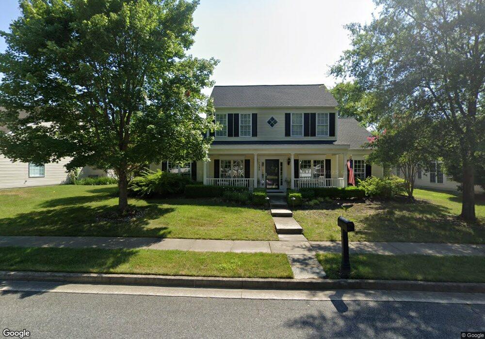
7390 Michael Ave Easton, MD 21601
Estimated Value: $513,015 - $541,000
Studio
3
Baths
2,342
Sq Ft
$224/Sq Ft
Est. Value
About This Home
This home is located at 7390 Michael Ave, Easton, MD 21601 and is currently estimated at $525,504, approximately $224 per square foot. 7390 Michael Ave is a home located in Talbot County with nearby schools including Easton Elementary School, Easton Middle School, and Easton High School.
Ownership History
Date
Name
Owned For
Owner Type
Purchase Details
Closed on
Jun 5, 2020
Sold by
Hu Shihcheng S and Hu Elizabeth
Bought by
Hu Elizabeth
Current Estimated Value
Home Financials for this Owner
Home Financials are based on the most recent Mortgage that was taken out on this home.
Original Mortgage
$106,000
Outstanding Balance
$74,517
Interest Rate
3.2%
Mortgage Type
New Conventional
Estimated Equity
$450,987
Purchase Details
Closed on
Jun 27, 2018
Sold by
Ohara Patrick H and Pierson Ohara Susan
Bought by
Hu Shihcheng S and Hu Elizabeth A
Purchase Details
Closed on
Sep 26, 2007
Sold by
Lyons Lc
Bought by
O'Hara Patrick H
Purchase Details
Closed on
Sep 14, 2007
Sold by
Lyons Lc
Bought by
O'Hara Patrick H
Create a Home Valuation Report for This Property
The Home Valuation Report is an in-depth analysis detailing your home's value as well as a comparison with similar homes in the area
Home Values in the Area
Average Home Value in this Area
Purchase History
| Date | Buyer | Sale Price | Title Company |
|---|---|---|---|
| Hu Elizabeth | -- | Mortgage Connect Lp | |
| Hu Shihcheng S | $375,000 | First American Title Insuran | |
| O'Hara Patrick H | $374,990 | -- | |
| O'Hara Patrick H | $374,990 | -- |
Source: Public Records
Mortgage History
| Date | Status | Borrower | Loan Amount |
|---|---|---|---|
| Open | Hu Elizabeth | $106,000 |
Source: Public Records
Tax History
| Year | Tax Paid | Tax Assessment Tax Assessment Total Assessment is a certain percentage of the fair market value that is determined by local assessors to be the total taxable value of land and additions on the property. | Land | Improvement |
|---|---|---|---|---|
| 2025 | $2,686 | $439,133 | $0 | $0 |
| 2024 | $2,608 | $404,900 | $93,000 | $311,900 |
| 2023 | $2,426 | $381,167 | $0 | $0 |
| 2022 | $2,198 | $357,433 | $0 | $0 |
| 2021 | $4,175 | $333,700 | $109,200 | $224,500 |
| 2020 | $2,023 | $332,200 | $0 | $0 |
| 2019 | $2,021 | $330,700 | $0 | $0 |
| 2018 | $1,732 | $329,200 | $109,200 | $220,000 |
| 2017 | $1,545 | $316,467 | $0 | $0 |
| 2016 | $1,487 | $303,733 | $0 | $0 |
| 2015 | $1,548 | $291,000 | $0 | $0 |
| 2014 | $1,548 | $291,000 | $0 | $0 |
Source: Public Records
Map
Nearby Homes
- 7401 Casey Ave
- 7371 Michael Ave
- 7477 Casey Ave
- 7344 Casey Ave
- 29885 Hillary Ave
- 29830 Hillary Ave
- 7389 Karen Ave
- 29653 Lyons Dr
- 29754 Hillary Ave
- 7459 Timothys Way
- 29580 Kent Ave
- 29595 Dutchmans Ln Unit 42/701
- 29595 Dutchmans Ln Unit 404
- 7390 Patrick Rd
- 29405 Jobes St
- 7347 Shirley Dr
- 7220 Fir St
- 29500 Cromwell Ln
- 29407 Jobes St
- 7853 Ward Brothers Cir
- 7396 Michael Ave
- 7384 Michael Ave
- 7366 Leo Ave
- 29827 Dustin Ave
- 0 St Michaels Rd Unit TA10043171
- 0 St Michaels Rd Unit TA10020106
- 7391 Michael Ave
- 7397 Michael Ave
- 7362 Leo Ave
- 29825 Dustin Ave
- 7387 Michael Ave
- 7403 Michael Ave
- 7381 Michael Ave
- 29823 Dustin Ave
- 7407 Michael Ave
- 7354 Leo Ave
- 7410 Michael Ave
- 7370 Michael Ave
- 7375 Michael Ave
- 7413 Michael Ave
Your Personal Tour Guide
Ask me questions while you tour the home.