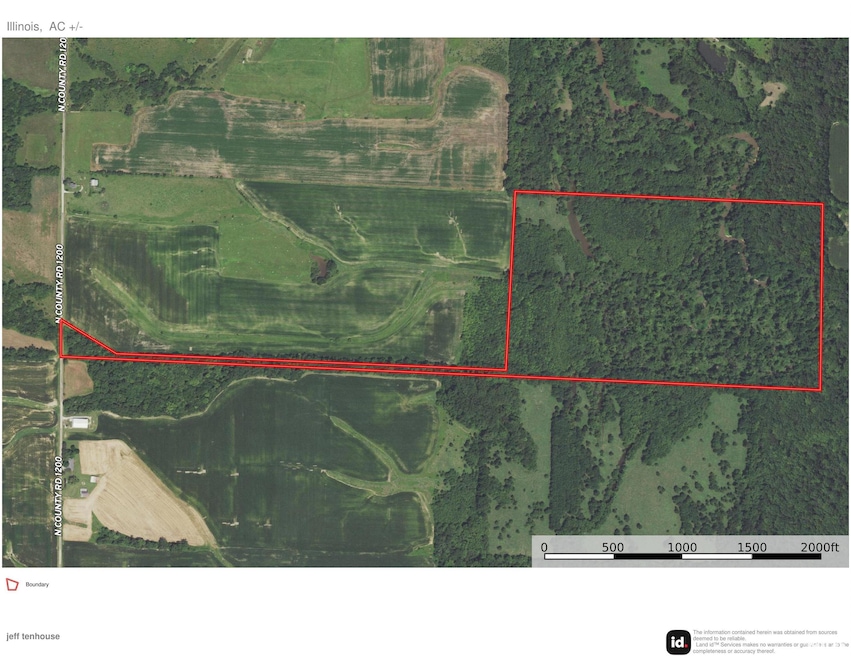
74.08 acres 13 Walker Twp West Point, IL 62380
Estimated payment $2,518/month
Highlights
- 70 Acre Lot
- Wooded Lot
- Agricultural
- Creek On Lot
- No HOA
About This Lot
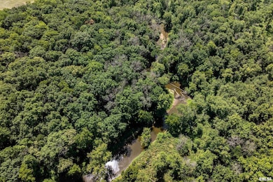
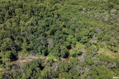
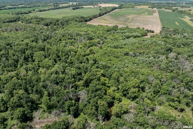
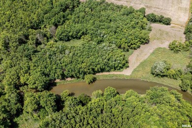
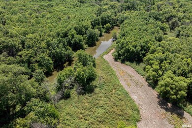
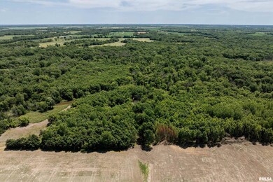
Take a look at this property! 30 minutes from Quincy and 3 miles from Adams County line! 10' wide ATV trail system with drainage tubes installed and paths mowed in the timber for easy access and fun on the weekends. You will see tremendous deer sign with well worn paths along with the fact that Bear Creek winds its way from north to south through the east end of the farm several sloughs, ditches and terrain features creating excellent pinch points. Also, for easy access a 40 foot wide deeded access to property and 25-30 ft access strip along west side of property. On top of all of that, there is 20.47 acres in CRP paying $248.03/acre. Bear Creek is a great trophy buck area. Farm is set up with food plots for trophy buck hunting and turkey hunting. A 170 trophy buck was taken 2023/24 season. A similar sized buck was taken on the neighboring farm. Game pictures are available on request. Taxes to be determined.
Listing Agent
Mays LLC REALTORS Brokerage Phone: 217-228-3100 License #475131403 Listed on: 10/17/2024
Property Details
Property Type
- Land
Est. Annual Taxes
- $4,190
Lot Details
- 70 Acre Lot
- Lot Dimensions are 2310x1320
- Wooded Lot
Schools
- Southeastern Elementary School
- Southeastern High School
Farming
- Agricultural
Utilities
- Private Water Source
- Sewer Not Available
Listing and Financial Details
- Assessor Parcel Number 22-13-000-165
Community Details
Overview
- No Home Owners Association
Recreation
- Creek On Lot
Map
Home Values in the Area
Average Home Value in this Area
Tax History
| Year | Tax Paid | Tax Assessment Tax Assessment Total Assessment is a certain percentage of the fair market value that is determined by local assessors to be the total taxable value of land and additions on the property. | Land | Improvement |
|---|---|---|---|---|
| 2024 | $4,647 | $57,505 | $40,134 | $17,371 |
| 2023 | $4,647 | $53,024 | $36,138 | $16,886 |
| 2022 | $4,190 | $47,041 | $32,428 | $14,613 |
| 2021 | $3,640 | $41,999 | $29,071 | $12,928 |
| 2020 | $3,397 | $38,257 | $26,052 | $12,205 |
| 2019 | $3,158 | $35,245 | $23,329 | $11,916 |
| 2018 | $2,956 | $33,175 | $20,877 | $12,298 |
| 2017 | $2,799 | $30,930 | $18,632 | $12,298 |
| 2015 | $1,829 | $25,883 | $14,752 | $11,131 |
| 2014 | $1,829 | $25,367 | $13,448 | $11,919 |
| 2012 | $1,829 | $23,108 | $11,189 | $11,919 |
Property History
| Date | Event | Price | List to Sale | Price per Sq Ft |
|---|---|---|---|---|
| 05/19/2025 05/19/25 | Price Changed | $412,500 | -8.3% | -- |
| 12/13/2024 12/13/24 | Price Changed | $450,000 | +7.1% | -- |
| 10/17/2024 10/17/24 | For Sale | $420,000 | -- | -- |
Purchase History
| Date | Type | Sale Price | Title Company |
|---|---|---|---|
| Warranty Deed | $815,000 | Near North Title | |
| Quit Claim Deed | -- | None Listed On Document | |
| Deed | $1,000,000 | -- | |
| Grant Deed | $130,000 | -- |
Mortgage History
| Date | Status | Loan Amount | Loan Type |
|---|---|---|---|
| Open | $500,000 | Credit Line Revolving |
Source: RMLS Alliance
MLS Number: CA1032575
APN: 22-13-000-165
Disclaimer: Certain information contained herein is derived from information provided by parties other than Homes.com. All information provided is deemed reliable, but is not guaranteed to be accurate and should be independently verified.
![]() IDX information is provided exclusively for personal, non-commercial use, and may not be used for any purpose other than to identify prospective properties consumers may be interested in purchasing. Information is deemed reliable but not guaranteed.
IDX information is provided exclusively for personal, non-commercial use, and may not be used for any purpose other than to identify prospective properties consumers may be interested in purchasing. Information is deemed reliable but not guaranteed.
- 321 N County Road 1200
- 0 E Co Road 350 Unit 23229905
- 75 N County Road 830
- 2882 E 1100th St
- 121 N Broad St
- 413 S Main St
- 1196 N County Road 1000
- 1930 E County Road 900 N
- 1182 N Co Road 630
- 1541 Elm St
- 201 N Laurel St
- 305 S 14th St
- 1220 Elm St
- 250-260 S 13th St
- 1275 Francis Sartory Rd
- 1050 Main St
- 334 E South St
- 1571 Laurel St
- 1310 Laurel St
- 0 Alvord St
