Estimated Value: $4,337,137 - $6,439,000
5
Beds
5
Baths
5,434
Sq Ft
$936/Sq Ft
Est. Value
About This Home
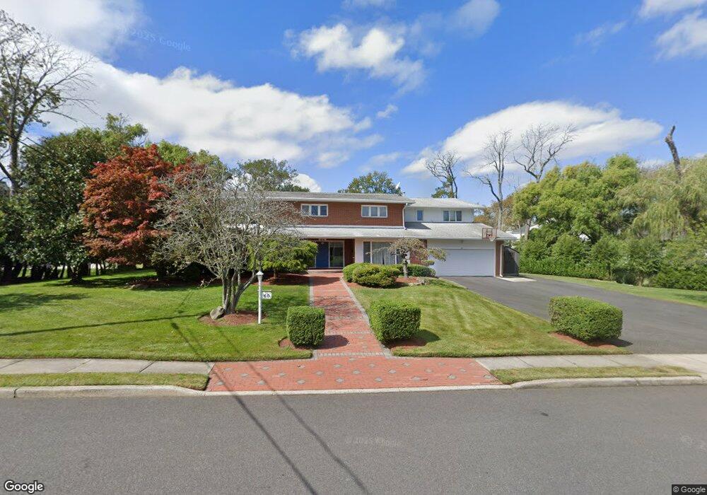
This home is located at 74 Almyr Ave, Deal, NJ 07723 and is currently estimated at $5,087,034, approximately $936 per square foot. 74 Almyr Ave is a home located in Monmouth County with nearby schools including Deal Elementary School, St. Mary of the Assumption School, and Ma'or Yeshiva High School for Boys.
Ownership History
Date
Name
Owned For
Owner Type
Purchase Details
Closed on
Apr 9, 2024
Sold by
Ades Morris
Bought by
Morris Ades Revocable Living Trust and Ades
Current Estimated Value
Purchase Details
Closed on
Jun 8, 2018
Sold by
Ades Morris and Ades Esther
Bought by
Ades Morris
Create a Home Valuation Report for This Property
The Home Valuation Report is an in-depth analysis detailing your home's value as well as a comparison with similar homes in the area
Home Values in the Area
Average Home Value in this Area
Purchase History
| Date | Buyer | Sale Price | Title Company |
|---|---|---|---|
| Morris Ades Revocable Living Trust | -- | None Listed On Document | |
| Morris Ades Revocable Living Trust | -- | None Listed On Document | |
| Ades Morris | -- | Stewart Title |
Source: Public Records
Tax History Compared to Growth
Tax History
| Year | Tax Paid | Tax Assessment Tax Assessment Total Assessment is a certain percentage of the fair market value that is determined by local assessors to be the total taxable value of land and additions on the property. | Land | Improvement |
|---|---|---|---|---|
| 2025 | $16,624 | $4,355,800 | $3,343,100 | $1,012,700 |
| 2024 | $15,351 | $3,893,300 | $2,984,900 | $908,400 |
| 2023 | $15,351 | $3,337,200 | $2,546,600 | $790,600 |
| 2022 | $14,910 | $2,523,700 | $1,968,600 | $555,100 |
| 2021 | $16,629 | $2,293,900 | $1,762,200 | $531,700 |
| 2020 | $17,419 | $2,439,600 | $1,050,300 | $1,389,300 |
| 2019 | $16,629 | $2,345,400 | $990,900 | $1,354,500 |
| 2018 | $15,040 | $2,167,200 | $907,200 | $1,260,000 |
| 2017 | $14,831 | $2,127,800 | $907,200 | $1,220,600 |
| 2016 | $13,866 | $1,983,700 | $847,800 | $1,135,900 |
| 2015 | $13,817 | $1,932,400 | $847,800 | $1,084,600 |
| 2014 | $12,333 | $1,727,300 | $906,500 | $820,800 |
Source: Public Records
Map
Nearby Homes
- 116 Phillips Ave
- 103 Poplar Ave
- 10 Campbell Ct
- 328 Elberon Blvd
- 0 Overbrook Ave
- 267 Roosevelt Ave
- 160 Ocean Ave
- 24 Berger Ave
- 206 S Lincoln Ave
- 271 Jerome Ave
- 1039 Norwood Ave
- 296 Garfield Ave
- 101 Lincoln Ave
- 306 Roosevelt Ave
- 1 Country Club Dr
- 210 Larchwood Ave
- 1001 Norwood Ave Unit 5
- 1001 Norwood Ave Unit 6
- 1 Private Dr
- 404 Brookside Ave