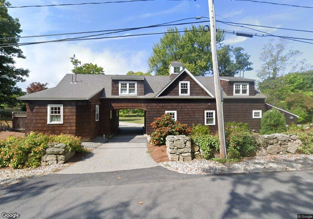
74 Beach St Cohasset, MA 02025
Estimated Value: $5,976,000 - $6,671,000
3
Beds
3
Baths
2,993
Sq Ft
$2,163/Sq Ft
Est. Value
About This Home
This home is located at 74 Beach St, Cohasset, MA 02025 and is currently estimated at $6,473,208, approximately $2,162 per square foot. 74 Beach St is a home located in Norfolk County with nearby schools including Joseph Osgood School, Deer Hill School, and Cohasset Middle School.
Ownership History
Date
Name
Owned For
Owner Type
Purchase Details
Closed on
Dec 30, 2024
Sold by
Verrochi Matthew and Verrochi Jessica R
Bought by
Gsd Nt Est and Bell
Current Estimated Value
Purchase Details
Closed on
Jan 10, 2018
Sold by
Power Family Llc
Bought by
Power Barbara M
Purchase Details
Closed on
Jan 3, 1972
Bought by
Power Family Llc
Create a Home Valuation Report for This Property
The Home Valuation Report is an in-depth analysis detailing your home's value as well as a comparison with similar homes in the area
Home Values in the Area
Average Home Value in this Area
Purchase History
| Date | Buyer | Sale Price | Title Company |
|---|---|---|---|
| Gsd Nt Est | $6,400,000 | None Available | |
| Gsd Nt Est | $6,400,000 | None Available | |
| Gsd Nt Est | $6,400,000 | None Available | |
| Power Barbara M | -- | -- | |
| Power Barbara M | -- | -- | |
| Power Family Llc | -- | -- | |
| Power Barbara M | -- | -- |
Source: Public Records
Tax History Compared to Growth
Tax History
| Year | Tax Paid | Tax Assessment Tax Assessment Total Assessment is a certain percentage of the fair market value that is determined by local assessors to be the total taxable value of land and additions on the property. | Land | Improvement |
|---|---|---|---|---|
| 2025 | $64,184 | $5,542,700 | $4,370,100 | $1,172,600 |
| 2024 | $67,561 | $5,551,400 | $4,885,100 | $666,300 |
| 2023 | $63,155 | $5,352,100 | $4,697,100 | $655,000 |
| 2022 | $66,524 | $5,296,500 | $4,697,100 | $599,400 |
| 2021 | $68,576 | $5,258,900 | $4,697,100 | $561,800 |
| 2020 | $67,740 | $5,222,800 | $4,697,100 | $525,700 |
| 2019 | $67,374 | $5,222,800 | $4,697,100 | $525,700 |
| 2018 | $59,332 | $4,638,900 | $4,005,300 | $633,600 |
| 2017 | $58,206 | $4,456,800 | $3,814,300 | $642,500 |
| 2016 | $57,404 | $4,456,800 | $3,814,300 | $642,500 |
| 2015 | $45,495 | $3,579,500 | $2,937,000 | $642,500 |
| 2014 | $42,715 | $3,406,300 | $2,763,800 | $642,500 |
Source: Public Records
Map
Nearby Homes
- 135 Beach St
- 11 Beach St
- 25 Mohawk Way
- 17 Mohawk Way
- 128 Elm St Unit 211
- 89 Ripley Rd
- 21-23 Elm Ct
- 146 N Main St Unit 146
- 18 Pleasant St
- 4 Margin St Unit A
- 25 Ripley Rd
- 87 Elm St Unit 215
- 12 Sheldon Rd
- 124 Elm St Unit 202
- 124 Elm St Unit 308
- 15 Cushing Rd
- 104 Howard Gleason Rd
- 101 Nichols Rd
- 100 Howard Gleason Rd
- 356 Atlantic Ave